General Discussion
Related: Editorials & Other Articles, Issue Forums, Alliance Forums, Region ForumsThe Map Of Native American Tribes You've Never Seen Before
http://www.npr.org/blogs/codeswitch/2014/06/24/323665644/the-map-of-native-american-tribes-youve-never-seen-beforeby HANSI LO WANG
June 24, 2014 4:03 PM ET
Finding an address on a map can be taken for granted in the age of GPS and smartphones. But centuries of forced relocation, disease and genocide have made it difficult to find where many Native American tribes once lived.
Aaron Carapella, a self-taught mapmaker in Warner, Okla., has pinpointed the locations and original names of hundreds of American Indian nations before their first contact with Europeans.
As a teenager, Carapella says he could never get his hands on a continental U.S. map like this, depicting more than 600 tribes — many now forgotten and lost to history. Now, the 34-year-old designs and sells maps as large as 3 by 4 feet with the names of tribes hovering over land they once occupied.

"I think a lot of people get blown away by, 'Wow, there were a lot of tribes, and they covered the whole country!' You know, this is Indian land," says Carapella, who calls himself a "mixed-blood Cherokee" and lives in a ranch house within the jurisdiction of the Cherokee Nation.
For more than a decade, he consulted history books and library archives, called up tribal members and visited reservations as part of research for his map project, which began as pencil-marked poster boards on his bedroom wall. So far, he has designed maps of the continental U.S., Canada and Mexico. A map of Alaska is currently in the works.
..more..
 = new reply since forum marked as read
Highlight:
NoneDon't highlight anything
5 newestHighlight 5 most recent replies
= new reply since forum marked as read
Highlight:
NoneDon't highlight anything
5 newestHighlight 5 most recent replies

Uncle Joe
(58,355 posts)Thanks for the thread, G_j.
liberal N proud
(60,334 posts)Thanks for sharing
riderinthestorm
(23,272 posts)Fascinating!

hunter
(38,311 posts)Thank you for posting this.
KittyWampus
(55,894 posts)for a stupid mistake I posted a while ago. LOL!

fleabiscuit
(4,542 posts)
SalviaBlue
(2,916 posts)rec

blackspade
(10,056 posts)That the Americas were a thriving place before Europeans showed up and trashed the place.
WHEN CRABS ROAR
(3,813 posts)TygrBright
(20,759 posts)I did not see them where I expected to, but then I'm sure they weren't called "Jicarilla," "Mescalero," etc. originally.
curiously,
Bright

Jackpine Radical
(45,274 posts)Here's a sample:
As I recall, the (closely related) Navaho call themselves "Diné."
TygrBright
(20,759 posts)And you're right, there they are on the map as "Ndeh," about where I'd expect to find them.
Thanks!
appreciatively,
Bright
Jackpine Radical
(45,274 posts)"Nasazi" (Anasazi) is Navaho for "Ancient Enemy."
On edit--Oops, they might only be on a US map.

tomm2thumbs
(13,297 posts)I had done some research years ago and though that may have been one conclusion.

Igel
(35,300 posts)It's not false. But it's not true.
He took earliest mentions of names of tribes and tried to avoid exonyms. The problem is that in much of the territory plagues had swept through before "first contact." In others, first contact happened in 1520, in others it happened in 1720. During that time tribes came and went as the result of disease, war, famine. As tribes spread out, they differentiated.
It also suffers from the problems that modern ethnolinguistics has. Take the "Lapplanders", the Saami (or whatever they're called now). If they compare themselves with outsiders, there's one language. But when it comes to establishing a standard, there are perhaps a dozen "languages," each with its norm and tribe behind it. So are they one tribe or many? It's not a historical problem--you get 40 of them together from different tribes, and you get a different answer in the morning in one context from in the afternoon, in a different content. At one point I studied "Serbo-Croatian"; now I have to specify that I studied ekavski stokavski Serbian, because the language is split into three N-S dialect zones, two E-W zones, and between Bosnian, Montenegran, Serbian, and Croatian. What was one language with different "varieties" is now a dozen languages. It's the same problem in determining the speciation of plants like echinofossulocactus in the Sonoran or Haworthia in S. Africa--how different does something need to be from something else before it's in a different category and gets a different name? Both botanists, linguists, and ethnologists form "splitters" and "lumpers".
Look at this guy's map for New Jersey. It's a large area. Other similarly wooded, fertile areas have multiple tribes. But he has one, because that's how they were perceived and how they found it convenient to band together. Given a different context, it's likely that they'd have been numerous tribes. Or the one tribe there had recently been busy with a genocidal campaign that wiped out the previous groups or assimilated them. (Or they'd recently spread into areas recently depopulated as a result of disease.)

hopemountain
(3,919 posts)than what european people tell us we must call ourselves according to their european immigrant experts and mapmakers.


Lochloosa
(16,063 posts)
ctsnowman
(1,903 posts)
byronius
(7,394 posts)maindawg
(1,151 posts)goes a long way in helping people understand that the American indian is a real person. I think the main reason that to this day the native American faces an dismissive additude when confronted by overt racism in America, is because people do not consider them to be 'real'
They are characters in an old movie. They were something we eliminated, a long time ago. Now, they dont count. While we have worked to destroy their culture, we condemn them for their dark skin,their lack of what we enjoy through our extended families. You see? While we condemn their culture we have magnified our own to the point that we do not respect their stature as human beings.
These maps should be in every classroom.

KurtNYC
(14,549 posts)10,000 years of history (and sustainable agriculture):
http://www.tolatsga.org/Compacts.html
Igel
(35,300 posts)Often for political or ideological reasons. Some of the larger ones are just plain screwy. On occasion you find sort of "let's add up all the largest estimates for a region over time" estimates--population of the Amazon at its peak, population of Cahokia at its peak, population of the SW US at its peak. Even if the peaks really didn't coincide in time.
The estimates for those lost to disease also vary.
However, while a lot of the agriculture was sustainable--most agriculture has been, over time, not so much because of cultural merit as technological inability to make it truly unsustainable--in some cases it wasn't. Some species were overfished in S. California and are well attested in middens, then their numbers dwindle and vanish. We only know them from fossils and from kitchen middens.
Mast was widely spread throughout the eastern portion of North America, with consequences for the species that were native. Pawpaw was not original to Texas through Quebec. It, too, was spread--and with it went some animal and insect species, and the space it took up was space lost to native species.
And there are places that had irrigation in the SW that were rendered unusable. Irrigation introduced too many salts into the soil. The same happened to "sustainable" irrigation in N. India, the Middle East, N. Africa.
hopemountain
(3,919 posts)
Thanks for this.

aint_no_life_nowhere
(21,925 posts)It was a collection of old photographs dating as far back as 1850 of the members of 50 California tribes, each with their own independent language and culture, that no longer exist. Of course there once were thriving tribes in places like what is now Beverly Hills or Malibu, but they were wiped out by things like disease, displacement and hard servitude in the Spanish Missions and almost no one remembers them.


H2O Man
(73,536 posts)Thank you for this.
It's funny how a post of this nature always attracts at least one person who feels compelled to dismiss it. I note a comment about New Jersey that is absolutely inaccurate. The population there developed in situ, from the late archaic phase. It is listed as one "tribe" (nation). The Lenni Lenapi were a sub-group of the larger Algonquin ethnic group. Within the Lenapi, various communities were named after places, and these were considered "tribes" by the early Euro-Americans. There was an effort, after the Revolutionary War, to have the Lenapi become another state within the union.
tomm2thumbs
(13,297 posts)thanks for sharing

reACTIONary
(5,770 posts)... map of the United States, in PDF format. Nice!
http://static.squarespace.com/static/5075febfe4b0782fde5414d9/t/51bfdc65e4b00b62a84e8d0f/1371528293927/TRIBALINKSPACEMAPS_ChooseOptions_39x26.pdf
G_j
(40,367 posts)thank you!
lovemydog
(11,833 posts)Thanks for sharing it!

KoKo
(84,711 posts)
nadinbrzezinski
(154,021 posts)here is the INAH map
And this is just linguistic groups
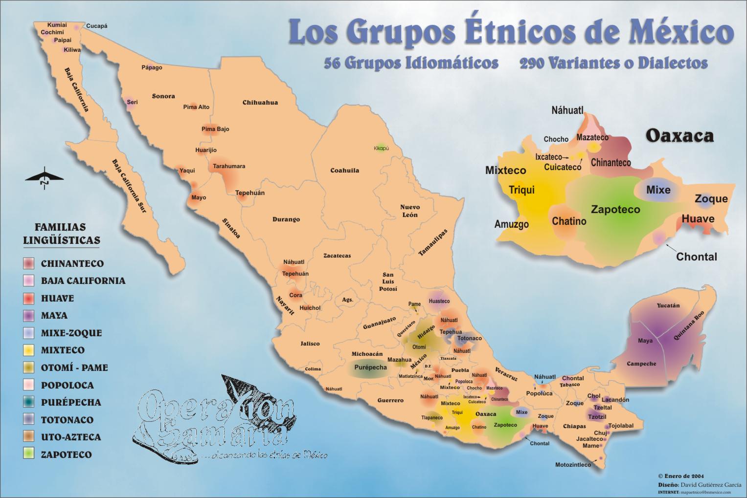
In Mexico there is a proud tradition of not just studying the prehispanic period and embracing it, but also the present multicultural and multilingual nation.
You go to Teotihuacan for example, and the signs are in Spanish English, French and Native Nahuatl. A cousin of mine works for the Colegio de Mexico (Researcher) and has worked all her live in a native sub group of Chiapaneca
DesertDiamond
(1,616 posts)
niyad
(113,277 posts)
theHandpuppet
(19,964 posts)Her people are Binizaa (Zapoteco) from the Oaxaca area.
Thanks for posting this! 

Gumboot
(531 posts)Thank you so much for doing this - it's very much appreciated!
I usually get blank stares from fellow progressives when the subject of Native Americans comes up. Guess they need to drive beyond city limits and open their eyes once in a while, ha ha!


raouldukelives
(5,178 posts)rhett o rick
(55,981 posts)indigenous peoples that lived in the Americas before Columbus to play down the horrible destruction. 