Large hail, high winds could hit Omaha metro area in two surges
Source: OMAHA WORLD HERALD
By Nancy Gaarder and Jay Withrow
The National Weather Service has upgraded the weather threat to "high" for an area that includes the Omaha/Des Moines corridor.
"High" means the chances for widespread severe damage have increased.
Just after 4 p.m., tornado sirens were sounding in the Omaha area due to the potential for winds of 75 mph or greater. But there was no tornado warning at that time.
***
Meanwhile, individual powerful storms have begun to occur in northern Nebraska and into South Dakota, a precursor of what lies ahead for the rest of the Midlands.
FULL story at link.
Read more: http://www.omaha.com/news/metro/large-hail-high-winds-could-hit-omaha-metro-area-in/article_55021f46-eb45-11e3-bd2f-001a4bcf6878.html
Hosts the upgrade is NEW not a dupe. The fist wave is over Omaha now.
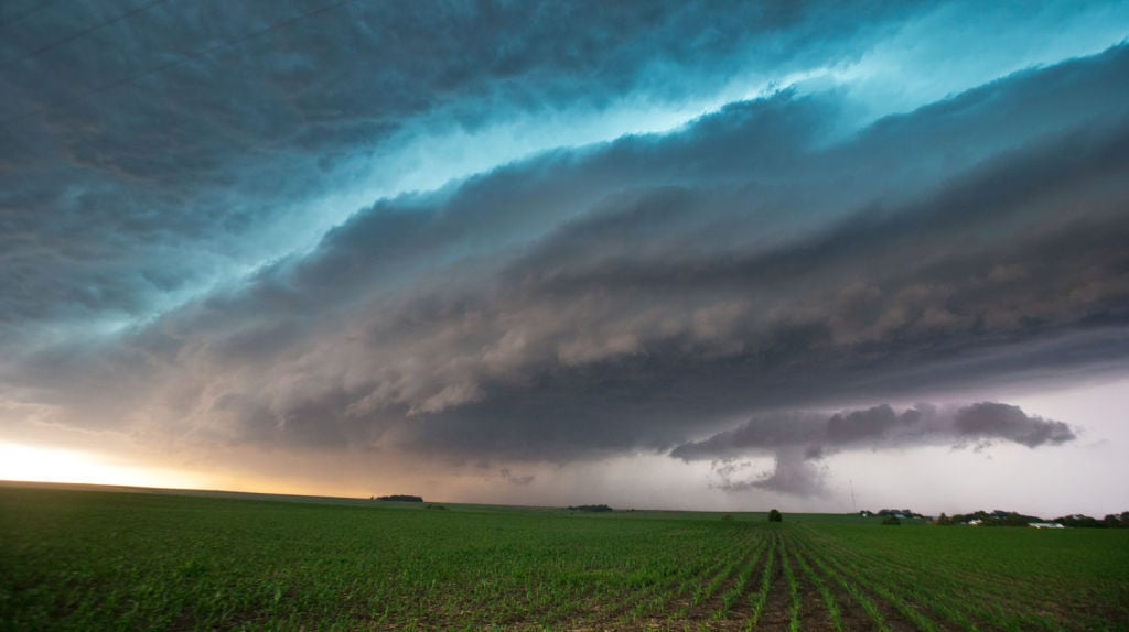
CHRIS MACHIAN/THE WORLD-HERALD
A storm that hit Norfolk, Nebraska, is seen just west of West Point on Tuesday afternoon.
 = new reply since forum marked as read
Highlight:
NoneDon't highlight anything
5 newestHighlight 5 most recent replies
= new reply since forum marked as read
Highlight:
NoneDon't highlight anything
5 newestHighlight 5 most recent replies

Louisiana1976
(3,962 posts)
Omaha Steve
(99,488 posts)http://apnews.excite.com/article/20140603/us-severe-weather-b595cc91a1.html
Jun 3, 6:20 PM (ET)
By BARBARA RODRIGUEZ
DES MOINES, Iowa (AP) — Severe weather packing baseball-size hail and heavy rain rolled into Nebraska on Tuesday afternoon as potentially dangerous storms targeted a number of Midwestern states, including South Dakota and Iowa where voters were casting ballots in primary elections.
The National Weather Service said the highest risk for severe weather was centered in parts of northern and eastern Nebraska, western and southern Iowa, and northeast Missouri. Officials said there was the potential for a weather event called a derecho, which is a storm of strong straight-line winds spanning at least 240 miles.
"This is one of these days we can't let our guard down," said Bill Bunting, forecast operations chief at the Storm Prediction Center in Norman, Oklahoma. "It's unfortunately panning out as we thought it would. This is shaping up as a very dangerous evening."
The weather could pack winds of up to 80 mph, large hail and up to 4 inches of rain. An outbreak of severe thunderstorms is forecast for the afternoon into the early hours of Wednesday. It is expected to also affect parts of Illinois, Kansas and South Dakota.
FULL story at link.

Algernon Moncrieff
(5,781 posts)Residents in Craig, NE report a small tornado hit; many trees down.
This the link to KETV Omaha's U-Local page with home photos and video
WOWT Omaha can be live streamed
e.t.a. WOWT just reported all sheriff's vehicles in Blair suffered severe hail damage.

D Man
(9 posts)Thanks for the live link.
Omaha Steve
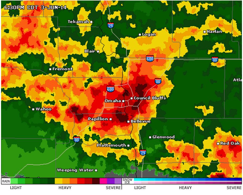
(99,488 posts)We are in Bellevue on the current radar map below. The storms are to come and go all night.

ForgoTheConsequence
(4,867 posts)Garden is gone. 12000 without power.
Algernon Moncrieff
(5,781 posts)Keep us posted
greatlaurel
(2,004 posts)Stay safe. That is a lot of people out of power. Good luck.

Judi Lynn
(160,448 posts)
OKNancy
(41,832 posts)come down to Oklahoma. This is kid's stuff.
Omaha Steve
(99,488 posts)Like that will happen.

OK I have been to Oklahoma City once.
greatlaurel
(2,004 posts)What a picture!
Judi Lynn
(160,448 posts)Storms with large hail and tornadoes roll through U.S. central states
Source: Reuters - Wed, 4 Jun 2014 01:45 AM
(Updates with damage, injuries in Omaha, reports of tornadoes, polls closing in Iowa)
By Mary Wisniewski
CHICAGO, June 3 (Reuters) - Severe storms pounded parts of the central United States on Tuesday producing baseball-sized hail, unconfirmed reports of several tornado touchdowns and a line of intense, dangerous winds known as a derecho, weather forecasters said.
Strong winds and baseball-sized hail caused widespread damage north of Omaha, Nebraska, Washington County officials said.
The severe weather halted flights at Omaha's Eppley Airfield for hours, which reported hail and strong wind gusts, and heavy rain caused flash flooding that closed area streets.
Storm chasers reported at least eight unconfirmed tornado touch-downs in Nebraska, one in Iowa and another in Wyoming, the National Weather Service said.
Hail, ranging from golf ball to tennis ball size, also pelted parts of Wyoming, the northern half of Nebraska and the southwestern corners of South Dakota and Iowa, the National Weather Service said.
More:
http://www.trust.org/item/20140604014322-0dlxe/