Fukushima now current on Google Maps
Google Maps finally updated the satellite photograph of Fukushima I Nuclear Power Plant. It shows the more-or-less current plant condition in great details.
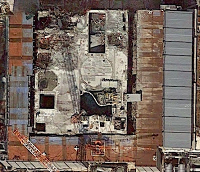
Instead of mangled steel beams and trusses completely covering the Reactor 3 operating floor, you actually see the Spent Fuel Pool, with water, with the half-submerged fuel handling machine:
Contrary to a belief still popular with people around the world (including Mr. Koide of Kyoto University) that the Reactor 4 building is still a smoking wreckage about to collapse at any moment, it now actually looks like this:

Removal of fuel assemblies from the Reactor 4 Spent Fuel Pool is now 70% finished, as of 6/16/2014. You can still see a lot of debris on the east side (ocean side) of the Reactor 4 building. Debris immediately around the reactor buildings has extremely high radiation contamination, according to the survey by TEPCO (I'll try to locate the document later).
Probably to suppress radiation and to prep for the frozen soil impermeable wall construction, the roads around the reactor buildings and the turbine buildings look to be paved with metal plates. Right where the trailer with Hitachi logo on top is where the frozen soil impermeable wall is being constructed near Reactor 1:
http://ex-skf.blogspot.com/2014/06/fukushima-i-npp-on-google-maps.html