Democratic Underground Latest Greatest Lobby Journals Search Options Help Login
Google

Rita's Impact could Rival Katrina and Dennis/ AccuWeather Update 12:03 edt

Printer-friendly format Printer-friendly format
Printer-friendly format Email this thread to a friend
Printer-friendly format Bookmark this thread
This topic is archived.
Home » Discuss » Latest Breaking News Donate to DU
 
KoKo Donating Member (1000+ posts) Send PM | Profile | Ignore Mon Sep-19-05 12:06 PM
Original message
Rita's Impact could Rival Katrina and Dennis/ AccuWeather Update 12:03 edt
http://headlines.accuweather.com/news-story.asp?partner=accuweather&myadc=0&traveler=0&article=0

Rita's Impact Could Rival Katrina & Dennis
Monday, September 19, 2005 12:03 PM EDT


Tropical Storm Rita is quickly gathering strength, and is expected to become a hurricane later today. It's impact on south Florida and the Florida Keys is going to be considerable, especially since those areas are still recuperating from Hurricane Katrina.
Because of Katrina's devastating impact on the Gulf Coast most people forget that after pounding South Florida the storm brought some very heavy rain to the Keys. In fact, 9.66" of rain fell on Key West on August 26th, the 5th highest daily rainfall amount in its history.
Florida Gov. Jeb Bush has declared a State of Emergency, and there is a mandatory evacuation order for all non-residents and tourists along with residents of mobile home communities and flood-prone regions. But as with Katrina, the bottom line is that this has the potential to be devastating, so the recommendation is for everyone in the Keys to get to safety.

Once Rita moves into the Gulf of Mexico it's going to intensify to at least Category 4 strength before making landfall by Friday or Saturday. AccuWeather's current projected path has landfall somewhere between Corpus Christie, Texas and Lake Charles, Louisiana
The storm could rival Katrina when it comes to economic impact. The Gulf supplies 29% of the nation's domestic oil production and 19% of the domestic gas production. According to Gary Strasburg of the federal Mineral Management Service there are some 4,000 oil rigs and platforms in the Gulf. As this MMS map shows, the majority of them are west of the path taken by Hurricane Katrina.
AccuWeather's hurricane expert Joe Bastardi says if Rita strikes Texas with Category 3 strength or higher the damage total could be as high as $10 to $15 Billion, a huge financial hit as the nation continues to recover from Hurricane Katrina. The price tag for Katrina's recovery efforts is expected to top $200 Billion.

AccuWeather's meteorologists and News Director Steve Penstone will continue to track Rita and its impact on the United States.
Printer Friendly | Permalink |  | Top
Geo55 Donating Member (1000+ posts) Send PM | Profile | Ignore Mon Sep-19-05 12:10 PM
Response to Original message
1. Yep, could be a BITCH !
If Rita reaches it's potential ,
Think about it....89-90 degree gulf water....we've been here before.
If it doesn't bust us as a nation.....surely it may wake the "majority" as to how vulnerable we are...."homeland security , indeed.........maybe it'll hit rich folks in the gulf ...(not that I wish that on ANYONE , ....but maybe...after Katrina , it will show where the power lies.


Printer Friendly | Permalink |  | Top
 
phantom power Donating Member (1000+ posts) Send PM | Profile | Ignore Mon Sep-19-05 12:10 PM
Response to Reply #1
2. Actually, Katrina dropped the Gulf temps by a couple degrees.
But they are still in the mid-80s, plenty to fuel a major hurricane.
Printer Friendly | Permalink |  | Top
 
Rainscents Donating Member (1000+ posts) Send PM | Profile | Ignore Mon Sep-19-05 01:14 PM
Response to Reply #2
27. Sorry, that's not ture. It droped temp for few days, but it's back up to
89 degree again!
Printer Friendly | Permalink |  | Top
 
phantom power Donating Member (1000+ posts) Send PM | Profile | Ignore Mon Sep-19-05 01:24 PM
Response to Reply #27
33. Not according to weather.com's surface-temp map:
Printer Friendly | Permalink |  | Top
 
rustydad Donating Member (753 posts) Send PM | Profile | Ignore Mon Sep-19-05 02:18 PM
Response to Reply #33
43. Temps may be down but...
...wind shear is usually less as fall come on. Hurricanes are very sensitive to wind shear in the upper atmosphere. They need a nice vertical exhaust pipe. This one could hit the Gulf oil rigs as bad as Katrina. bob
Printer Friendly | Permalink |  | Top
 
joeunderdog Donating Member (1000+ posts) Send PM | Profile | Ignore Tue Sep-20-05 06:31 AM
Response to Reply #43
89. Global Warming
Aren't dramatically increased storm severity and frequency one of the more immediate impacts of Global Warming? This is such a juicy news angle, I don't know why they don't play on it. This news angle would generate infinite debate and emotion. It might actually educate people, so we wouldn't want that.

The water temperature of the Gulf has steadily risen to become 5-7* higher than what has been historically normal, and this creates more extreme weather systems like we are seeing time and again.
Printer Friendly | Permalink |  | Top
 
saigon68 Donating Member (1000+ posts) Send PM | Profile | Ignore Tue Sep-20-05 09:09 AM
Response to Reply #89
104. I wonder if KindaSleezy Rice will cast a spell on it


Or put a Hex on it so it goes off and punishes the Mexican drug dealers
Printer Friendly | Permalink |  | Top
 
demo dutch Donating Member (1000+ posts) Send PM | Profile | Ignore Wed Sep-21-05 10:06 AM
Response to Reply #89
177. NPR had a whole program on that this morning. Opinions are still divided
just like some scientists were saying for years that there was no such thing as the Greenhouse effect on Global Warming.
Printer Friendly | Permalink |  | Top
 
donheld Donating Member (1000+ posts) Send PM | Profile | Ignore Tue Sep-20-05 05:52 PM
Response to Reply #1
138. could be a BITCH
What does Barbara Bush have to do with this? :evilgrin:
Printer Friendly | Permalink |  | Top
 
Village Idiot Donating Member (1000+ posts) Send PM | Profile | Ignore Mon Sep-19-05 12:10 PM
Response to Original message
3. Jeebus help us all...
Printer Friendly | Permalink |  | Top
 
Richard D Donating Member (1000+ posts) Send PM | Profile | Ignore Mon Sep-19-05 12:11 PM
Response to Original message
4. It'll be interesting to see . . .
. . . the difference in government response if Rita has a similar impact that Katrina had in New Orleans on a Tex ax city like Houston.
Printer Friendly | Permalink |  | Top
 
WePurrsevere Donating Member (1000+ posts) Send PM | Profile | Ignore Mon Sep-19-05 12:19 PM
Response to Reply #4
10. They'll be there PDQ just as they were for ones that hit Florida BUT...
the Republicans will say it's because they've learned a lesson from Katrina... not because it's "Texas".

To quote my now grown DD "Uh huh... sure... right... yeah... whatever :eyes: "
Printer Friendly | Permalink |  | Top
 
Richard D Donating Member (1000+ posts) Send PM | Profile | Ignore Mon Sep-19-05 12:28 PM
Response to Reply #10
15. yeah . . .
. . . I thought of that just after I posted. Hopefully something we won't have to find out.
Printer Friendly | Permalink |  | Top
 
SoCalDem Donating Member (1000+ posts) Send PM | Profile | Ignore Mon Sep-19-05 12:39 PM
Response to Reply #10
19. They will say.."See what a GOOD governor does" (a republican one)
:puke:
Printer Friendly | Permalink |  | Top
 
Justyce Donating Member (1000+ posts) Send PM | Profile | Ignore Mon Sep-19-05 12:46 PM
Response to Reply #19
21. Perry is the sorriest excuse for
a governor we've ever had second only to bush... of course he's a bush buddy, so that explains that.
Printer Friendly | Permalink |  | Top
 
Tight_rope Donating Member (1000+ posts) Send PM | Profile | Ignore Tue Sep-20-05 06:18 AM
Response to Reply #21
87. I second that response. Perry is useless like his buddy Bush!
Printer Friendly | Permalink |  | Top
 
Katidid Donating Member (310 posts) Send PM | Profile | Ignore Mon Sep-19-05 06:11 PM
Response to Reply #4
72. Texas is already under "state of emergency"
so this is really going to be interesting. Wonder if they are already moving the oil, securing the refineries ... Isn't Haliburton's home office based in Houston too?
Printer Friendly | Permalink |  | Top
 
tammywammy Donating Member (1000+ posts) Send PM | Profile | Ignore Mon Sep-19-05 12:13 PM
Response to Original message
5. I'm praying that it moves west of Houston
I know my grandfather will evacuated, like tomorrow, if there's any chance it'll hit him (SE of Houston, 30 min from LA).

But one of my uncles is always stuck at the refinery. :(
Printer Friendly | Permalink |  | Top
 
Up2Late Donating Member (1000+ posts) Send PM | Profile | Ignore Mon Sep-19-05 02:17 PM
Response to Reply #5
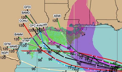
42. I know this is still a little early, but check out this forecast track
This is from Tropical Storm Risk .com <http://tsr.mssl.ucl.ac.uk/>, which I found to be very accurate for most storms. They predicted Katrina's landfall almost exactly at about 5 days out.


According to this, the Texas landfall would be in about 117 hours from now.

(NOTE: I'm posting this on September 19, 2005 at 3:00pm EDT)

I found this website about two years ago, and they are almost always right, although sometime they underestimate the actual wind speed. At this point in Katrina's track, they were predicting a Cat. 3 storm.

You might want to copy this link and check back in on it about every 6-12 hours. <http://tsr.mssl.ucl.ac.uk/>
Printer Friendly | Permalink |  | Top
 
tammywammy Donating Member (1000+ posts) Send PM | Profile | Ignore Mon Sep-19-05 02:26 PM
Response to Reply #42
47. Thanks for the link
I'm not too worried about my family. If they need to get out, then they will, with the exception of the few that will have to stay behind at the refinery.

They live in the Beaumont/Pt Arthur area, that's why I'd hope for west of Houston.

Thanks that link will be handy. :)
Printer Friendly | Permalink |  | Top
 
lastliberalintexas Donating Member (1000+ posts) Send PM | Profile | Ignore Mon Sep-19-05 05:54 PM
Response to Reply #47
70. West of Houston still puts us on the bad side
Houston, Galveston, Beaumont and Port Arthur could still have fairly significant damage from a category 4 hurricane even if it hit to the west of Houston. Unless by west, you meant Corpus or Brownsville. :)

If it has to hit anywhere, the deserted estuaries and bays of central LA would probably show the least impact on us humans.
Printer Friendly | Permalink |  | Top
 
tammywammy Donating Member (1000+ posts) Send PM | Profile | Ignore Mon Sep-19-05 07:09 PM
Response to Reply #70
73. Yeah by west
I do mean WEST to Corpus or Brownsville. :)

Printer Friendly | Permalink |  | Top
 
Tight_rope Donating Member (1000+ posts) Send PM | Profile | Ignore Tue Sep-20-05 06:23 AM
Response to Reply #70
88. Living in Houston for over 25 years..
Edited on Tue Sep-20-05 06:24 AM by Tight_rope
Yesterday, I went out and bought extra water, candles and other things to get prepared. This morning I'm going to fill up the tank. I know Houston...IT WILL FLOOD. No doubt about it.
Printer Friendly | Permalink |  | Top
 
burrowowl Donating Member (1000+ posts) Send PM | Profile | Ignore Tue Sep-20-05 12:39 AM
Response to Reply #42
81. In 117 hours but
downgraded to TS tropical strom, meaning less wind but lots of water.
Printer Friendly | Permalink |  | Top
 
Lone_Star_Dem Donating Member (1000+ posts) Send PM | Profile | Ignore Mon Sep-19-05 12:14 PM
Response to Original message
6. Doesn't look good
They're now saying it could be at a least Category 4.

I can't imagine what the people on the Texas coast who're victims of Katrina must be thinking.
Printer Friendly | Permalink |  | Top
 
Up2Late Donating Member (1000+ posts) Send PM | Profile | Ignore Mon Sep-19-05 02:29 PM
Response to Reply #6
48. The people? How about the Children? They will probably freak out!
Most of the displaced LA children will most likely thing that God Hates them.

It will be interesting to see how much different the WH, FEMA and the City of Houston react to this. How much you want to bet that Texas gets almost instant help?

But if it turns south and hits Brownsville, all bets are off. If it hits Brownsville and we see similar "mobilization and Logistics problems," I think anyone who still doubts the racial aspect of N.O. will become believers.
Printer Friendly | Permalink |  | Top
 
Lone_Star_Dem Donating Member (1000+ posts) Send PM | Profile | Ignore Mon Sep-19-05 06:04 PM
Response to Reply #48
71. I included them as people
But I do get your point special attention needs to be paid to them right now. This is going to wreck havoc on the children especially.
Printer Friendly | Permalink |  | Top
 
CountAllVotes Donating Member (1000+ posts) Send PM | Profile | Ignore Mon Sep-19-05 12:14 PM
Response to Original message
7. two words
HOLY SHIT!

:kick:
Printer Friendly | Permalink |  | Top
 
jus_the_facts Donating Member (1000+ posts) Send PM | Profile | Ignore Mon Sep-19-05 12:16 PM
Response to Original message
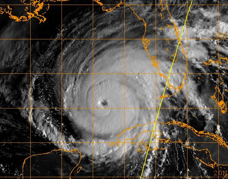
8. latest satellite photo from GOES.....
:scared:

Printer Friendly | Permalink |  | Top
 
corkhead Donating Member (1000+ posts) Send PM | Profile | Ignore Tue Sep-20-05 12:38 PM
Response to Reply #8
119. OMG! There's another Hurricane in Quebec!!!
:silly:
Printer Friendly | Permalink |  | Top
 
intheflow Donating Member (1000+ posts) Send PM | Profile | Ignore Mon Sep-19-05 12:17 PM
Response to Original message
9. I'm worried it will hit Houston.
Edited on Mon Sep-19-05 12:19 PM by intheflow
that would be devastating for evacuees who have felt safe in Houston. Houston is prone to flooding, too. It would be double PTSD. Very bad, indeed.

*Edited to add I nominated the thread.
Printer Friendly | Permalink |  | Top
 
gkhouston Donating Member (1000+ posts) Send PM | Profile | Ignore Mon Sep-19-05 12:32 PM
Response to Reply #9
16. Houston is prone to flooding, but it wouldn't be the
all-encompassing flooding New Orleans experienced. We're 50 miles inland and 50 feet above sea level, so the problem wouldn't be the storm surge so much as the rain flooding all the bayous. The streets would be impassable for a while and some buildings would get water but things would drain quickly after the storm moved on. It would be a horrendous mess and very traumatic for the evacuees but most of the water would run off in a matter of hours. The biggest physical problem would be power outages and blocked roads (branches, stalled cars) in the aftermath. And all those carpets on the curb, waiting for trash pickup. ;(

I agree, though; when it comes to trauma, the only thing worse than NOLA taking another hit would be for Galveston/Houston to take one on the chin right now, with so many evacuees here. The storm track has shifted a lot in the last twelve hours, though, so anything could happen.
Printer Friendly | Permalink |  | Top
 
merci_me Donating Member (1000+ posts) Send PM | Profile | Ignore Mon Sep-19-05 01:12 PM
Response to Reply #16
26. That's what I used to think too,
But back in February the Chronicle ran a three part series of what could happen in Houston if a major hurricane hit Galveston. If a major surge hit the ship channel, the force could send the water rushing up almost every bayou in the city. Of course, it would be within minutes, not the slow rise of the heavy rains we get.

It showed maps of where the banks would overflow and they included the reservoir at HWY 6 and I-10 and the Bear Creek overflow area, a good ways away from the coast. It would depend on how fast and efficient the pumping was at the various bayou stations and anyone who lives near one knows, it ain't so hot. But even with the pumping, where would it go? To the ship channel, where it came surging in?

Just a good quick downpour will flood our street up over the sidewalk. I hate to imagine what would happen if a 1/4 mile away, the Buffalo Bayou overran it's banks. Plus, because of the fact that the city resurfaced many of the streets around here by just pouring more concrete over the cracked concrete, they effectively covered most drainpipes that took water out of our backyards. We like many neighbors installed sump pumps to carry the water onto our driveways, to run out to the street. Unfortunately, the sump pumps require the electricity to be working.

We wouldn't be completely underwater, but there were homes as far in as I-10 and Wilcrest that during Tropical Storm Alison a few years ago, ended up with 2 ft of water from bayou overflowing.

Printer Friendly | Permalink |  | Top
 
gkhouston Donating Member (1000+ posts) Send PM | Profile | Ignore Mon Sep-19-05 02:10 PM
Response to Reply #26
41. man, that sucks. I wonder how big a surge it would take
to do that, and whether a category 3 would have enough power to make that happen. I sure don't remember anything like that happening during Alicia, but I was living in Austin at the time. A storm doesn't have to a have a lot of wind force to be bad news for Houston, as we saw with Allison. All of the development that's happened in the last twenty years has left us with lots of pavement and no place for the water to go except into the bayous. And if they're not wide enough or deep enough to carry the outflow... or something's pushing into them from the Bay... :scared:
Printer Friendly | Permalink |  | Top
 
wildflower Donating Member (1000+ posts) Send PM | Profile | Ignore Tue Sep-20-05 12:52 PM
Response to Reply #26
120. I remember hearing about the flooding of Houston in 2001 from Allison
A lot of structures nearly underwater and deaths from drowning. I remember a story about people taking an elevator down to the bottom of a building and drowning.

I found a site on it:

http://www.chron.com/content/chronicle/special/01/flood/index.html
Printer Friendly | Permalink |  | Top
 
Oreo Donating Member (1000+ posts) Send PM | Profile | Ignore Tue Sep-20-05 03:51 PM
Response to Reply #120
128. That happened in our building
Edited on Tue Sep-20-05 03:51 PM by Oreo
We had to move our office because of Allison. Couldn't get in for 2 weeks.
Printer Friendly | Permalink |  | Top
 
Carni Donating Member (1000+ posts) Send PM | Profile | Ignore Mon Sep-19-05 12:23 PM
Response to Original message
11. Are the freeps still yukking it up over Al's "Earth in balance" book?
Haven't soiled myself to go over and see what they are spewing recently... but if these dumb asses haven't acknowledged the reality of global warming yet, they are even more stupid than their emperor.
Printer Friendly | Permalink |  | Top
 
adarling Donating Member (1000+ posts) Send PM | Profile | Ignore Mon Sep-19-05 12:23 PM
Response to Original message
12. Well its a force of nature
Added that global warming is making it into Super force of nature its just a given. I just pray that they get the people out that can't make it out on their own. if i have to i will fly my ass there, get a van and drive people out myself. Shouldn't have to do that since we have all that money to dish out in the government.

Printer Friendly | Permalink |  | Top
 
GOPAgainstGW Donating Member (1000+ posts) Send PM | Profile | Ignore Mon Sep-19-05 12:24 PM
Response to Original message
13. BS Alert: Intensify to at least Category 4 strength...
Edited on Mon Sep-19-05 12:28 PM by GOPAgainstGW
I hate Accuweather because they make up garbage like this just for headlines. There is no current official or knowledgable data that Hurricane Rita will be at least a Cat 4. Doesn't mean it could not be, but that Joe Bastardi is a total flake.

However, no problemo. I have the answer for us Houstonians - Motley Crue is playing at the Toyota Center Saturday night where we can all seek shelter before the hurricane hits, like the N.O. citizens did in the Superdome for Katrina. May have to be an accoustic set with flashlights and no A/C, but what the hell. Motley Crue can sing some of their best songs for us hurricane Rita shelter victims while we wait 5 days for any form of help, hydration, and nutrition. Such Crue classics as:

1. Toilets Overflowing in the Boys Room.
2. Same 'Ol Situation
3. Afraid, and their new hit single
4. "If I Die Tomorrow"


PS: I can say stuff like this because I'm a Republican, lol.
Printer Friendly | Permalink |  | Top
 
KoKo Donating Member (1000+ posts) Send PM | Profile | Ignore Mon Sep-19-05 12:35 PM
Response to Reply #13
18. I just updated below with Dr. Jeff Masters Weather Underground Report.
He has category three but it's days out, and anything could happen.
Printer Friendly | Permalink |  | Top
 
GOPAgainstGW Donating Member (1000+ posts) Send PM | Profile | Ignore Mon Sep-19-05 12:49 PM
Response to Reply #18
22. Bouy Marker 42003 - Taken Out by Katrina. Check This Out!
Edited on Mon Sep-19-05 01:06 PM by GOPAgainstGW
Bouy Marker 42003, E GULF 260 nm South of Panama City, FL, survived Hurricane Ivan, which produced the largest wave heights on record, in the area. Hurricane Katrina took out Bouy Marker 42003 and it's a large and very stable ocean bouy.

I was tracking all the bouy marker data before NOAA's system went down with Katrina. Saw 68 ft wave height at BM-42003 before it got wiped out. In theory this is suppose to be the back side of the wave, not the front which is even larger. Impressive!

Luckly BM-42001 is still intact, post Katrina, but NOAA has been having some trouble with it. BM-42002, W GULF 240 nm South-Southeast of Sabine, TX, is in great shape however.
Printer Friendly | Permalink |  | Top
 
jus_the_facts Donating Member (1000+ posts) Send PM | Profile | Ignore Mon Sep-19-05 12:45 PM
Response to Reply #13
20. Vince Neil broke his leg the other night after fallin' off the stage....
....wonder if they'll have to cancel the tour or postpone it. :shrug:

http://www.ledger-enquirer.com/mld/ledgerenquirer/12673629.htm
Printer Friendly | Permalink |  | Top
 
GOPAgainstGW Donating Member (1000+ posts) Send PM | Profile | Ignore Mon Sep-19-05 01:03 PM
Response to Reply #20
23. Report was BS. He tore a Calf Muscles on stage.....
and performed again last night, despite the doctor telling him to take a Tour break. Crue doesn't plan on missing any tour dates because of his injury which is very painful and greatly limits his mobility.
Printer Friendly | Permalink |  | Top
 
Ben Ceremos Donating Member (387 posts) Send PM | Profile | Ignore Mon Sep-19-05 01:08 PM
Response to Reply #13
24. I find
your use of fake Spanish appalling. It discredits anything you have to say. In proper Spanish, the language spoken by several tens of millions of people worldwide, there is no such phrase or sentence as "No problemo". Stop polluting my native language with your neologism. In Spanish, when there is no problem, we say "No hay problema." Only the ignorant persist in disseminating such a ridiculous phrase as "no problemo".Furthermore, I have to assume that any Spanish speaker who hears you say this thinks of you in less than favorable fashion. To follow your lead, "There AIN'T NO problem with being dumb" (notice the double negative).

Por favor, Ud. debe aprender la lengua antes de tratar de usarla.
Printer Friendly | Permalink |  | Top
 
redwitch Donating Member (1000+ posts) Send PM | Profile | Ignore Mon Sep-19-05 01:15 PM
Response to Reply #24
28. That's a little harsh, don't you think?
You catch more flies with honey...
Explain gently, improve someone's foreign language skills vs be hostile and make them angry and resentful.
Kind of what we call a no brainer in English, don't know the Spanish for it.
Printer Friendly | Permalink |  | Top
 
Name removed Donating Member (0 posts) Send PM | Profile | Ignore Mon Sep-19-05 01:16 PM
Response to Reply #24
29. Deleted message
Message removed by moderator. Click here to review the message board rules.
 
redwitch Donating Member (1000+ posts) Send PM | Profile | Ignore Mon Sep-19-05 01:19 PM
Response to Reply #29
30. I was talking to the previous poster
Edited on Mon Sep-19-05 01:20 PM by redwitch
but how nice you are to take back YOUR harsh words. I totally understood your reaction though. :-)

Never mind. ( In her best Emily Latella) LOL
Printer Friendly | Permalink |  | Top
 
PunkPop Donating Member (847 posts) Send PM | Profile | Ignore Mon Sep-19-05 01:22 PM
Response to Reply #24
31. Hey, Congratulations!
That is about the most unwarranted, assinine attack I have ever seen on DU.
Printer Friendly | Permalink |  | Top
 
karlrschneider Donating Member (1000+ posts) Send PM | Profile | Ignore Mon Sep-19-05 01:24 PM
Response to Reply #24
34. conio
:eyes:
Printer Friendly | Permalink |  | Top
 
CBGLuthier Donating Member (1000+ posts) Send PM | Profile | Ignore Mon Sep-19-05 02:40 PM
Response to Reply #24
51. He was quoting the Fonz
And the Fonz was italian so if anything it's bastardised italian.
Printer Friendly | Permalink |  | Top
 
peacebuzzard Donating Member (1000+ posts) Send PM | Profile | Ignore Mon Sep-19-05 03:25 PM
Response to Reply #24
58. Welcome to DU, Ben Ceremos
Edited on Mon Sep-19-05 03:26 PM by peacebuzzard
Don't worry about the language around these threads, Ben, I find DU to have the most interesting source of words and expressions and ideas available anywhere. If you know of anything or anywhere else, let me know, cause I would like to check it out. If you are an avid reader you will discover each poster has his/her own style and alot of it regionally typical and so slang at times it becomes its own language. That is the beauty of American English anyway... the dynamic aspect. American English in particular has absorbed and initiated and morphed so much that it is light years away from what it originally was and you will find as a critic you will grow to appreciate the fluidity and diversity on these boards.

I also speak another language, Portuguese, and gave up many years ago trying to correct and point out the importance of my second language as I find that English is the most concise, easily assimilated and defined communication tool available.

Another publication that fascinates me as far as the English choice of words is "Wired" (and I have read it solely for the language choices and structures--not because I understand the subject content--which is normally way over my comprehension level)

Anyways, welcome to DU, I enjoyed your other post today in regards to Chavez and Cuba.
:hi:
Printer Friendly | Permalink |  | Top
 
Divernan Donating Member (1000+ posts) Send PM | Profile | Ignore Mon Sep-19-05 03:46 PM
Response to Reply #24
60. Que lastima? Que pobrecito?
I'm trying to recall appropriate phrases to express sympathy, but it's been many decades since my Spanish classes. It is a beautiful language. However, that phrase, no problemo, is so commonly used, that I hate to see you get so upset at it. There are so many more important things with which to be concerned, and which you probably have some insights to share with us on this board In particular, I would be interested on your thoughts concerning the US relationship with Mexico, Central American and Latin American countries. So I hope you stick around.

Buenos dios, senor!

PS - I was advised before my first trip to France, that I should try to speak my (pathetique) French, so as not to appear as some arrogant US/American expecting everyone to speak English. I did, and most of the French people then graciously spoke English to me. Of course I prefaced every attempt with an apology for my poor abilities in the French language.
Printer Friendly | Permalink |  | Top
 
Moxygirl Donating Member (36 posts) Send PM | Profile | Ignore Mon Sep-19-05 04:54 PM
Response to Reply #24
61. No problemo Pardner
Printer Friendly | Permalink |  | Top
 
Name removed Donating Member (0 posts) Send PM | Profile | Ignore Mon Sep-19-05 05:16 PM
Response to Reply #24
63. Deleted message
Message removed by moderator. Click here to review the message board rules.
 
Jim Warren Donating Member (1000+ posts) Send PM | Profile | Ignore Mon Sep-19-05 05:41 PM
Response to Reply #63
65. Ah.....no, actually it's not.
The colloquialism you're thinking of would be "chinga", though mi madre would not think it proper.
Printer Friendly | Permalink |  | Top
 
geebensis Donating Member (225 posts) Send PM | Profile | Ignore Mon Sep-19-05 05:48 PM
Response to Reply #65
67. Why did you tell him?
...it's much more fun to imagine him trying to insult people in another language, only to be rewarded by uncomprehending stares or derisive laughter.
Printer Friendly | Permalink |  | Top
 
Tom Yossarian Joad Donating Member (1000+ posts) Send PM | Profile | Ignore Tue Sep-20-05 07:06 AM
Response to Reply #67
92. I've got a link with more references to the original spelling than you can
Printer Friendly | Permalink |  | Top
 
Tom Yossarian Joad Donating Member (1000+ posts) Send PM | Profile | Ignore Mon Sep-19-05 05:51 PM
Response to Reply #65
69. I've seen it singa and chinga as well...
I've heard it as chinga more often though.

:toast:

Printer Friendly | Permalink |  | Top
 
Name removed Donating Member (0 posts) Send PM | Profile | Ignore Mon Sep-19-05 09:52 PM
Response to Reply #24
77. Deleted message
Message removed by moderator. Click here to review the message board rules.
 
Kailassa Donating Member (1000+ posts) Send PM | Profile | Ignore Wed Sep-21-05 01:20 AM
Response to Reply #77
152. how?
If I don't make myself heard, how can I prove my worth?

Perhaps all you mean is that newcomers shouldn't be criticising other posters; with that I agree. Personal criticism and complaints over spelling and grammer are simply a waste of time. One of the things I like about this forum is the courtesy shown by most contributers.
Printer Friendly | Permalink |  | Top
 
TankLV Donating Member (1000+ posts) Send PM | Profile | Ignore Mon Sep-19-05 10:47 PM
Response to Reply #24
78. Oh for christ sake! Chill out dude!
"No problemo" is part of the lexicon of the country. So are a lot of other "innacurate" phrases.

Just joined up to criticize us, huh?

No problemo for you, dude!
Printer Friendly | Permalink |  | Top
 
Megahurtz Donating Member (1000+ posts) Send PM | Profile | Ignore Tue Sep-20-05 05:54 PM
Response to Reply #78
139. Yeah, seriously, BFD if the guy says
"no problemo"!
I mean, who fucking cares?:shrug:
Printer Friendly | Permalink |  | Top
 
Hardrada Donating Member (1000+ posts) Send PM | Profile | Ignore Wed Sep-21-05 02:39 AM
Response to Reply #78
154. Actually the correct phrase should be "Kein Problem"
auf Deutsch naturlich!!
Printer Friendly | Permalink |  | Top
 
ldf Donating Member (1000+ posts) Send PM | Profile | Ignore Tue Sep-20-05 08:25 AM
Response to Reply #24
99. does that mean that i can't use
nyet problemski, either?

no problemo is SOOOO 1990's.

lighten up.

:-)
Printer Friendly | Permalink |  | Top
 
President Kerry Donating Member (1000+ posts) Send PM | Profile | Ignore Tue Sep-20-05 05:45 PM
Response to Reply #99
136. ah, that'd be "bez problem", dude
now you're bastardizing my language :toast:

En lo que se trata de la expresion, Ben, es una expresion corriente sin intencion de lastimar a ningun hispanohablante. Asi que tranquilate, y bienvenido a DU! :toast:
Printer Friendly | Permalink |  | Top
 
TahitiNut Donating Member (1000+ posts) Send PM | Profile | Ignore Tue Sep-20-05 09:59 AM
Response to Reply #24
109. It's one thing to tilt at windmills, yet another to rant at weather vanes.
I thought you might appreciate a Don Quixote allusion. :shrug:
Printer Friendly | Permalink |  | Top
 
JohnLocke Donating Member (1000+ posts) Send PM | Profile | Ignore Tue Sep-20-05 06:48 PM
Response to Reply #24
143. Por favor, quita el palillo en su asno.
Printer Friendly | Permalink |  | Top
 
Bridget Burke Donating Member (1000+ posts) Send PM | Profile | Ignore Wed Sep-21-05 07:31 AM
Response to Reply #24
166. Sorry, Spanglish is spoken here in Texas.
Quite a few people capable of speaking good Spanish & good English play around & mix the languages.

If snobs on both sides of the Border are offended--too bad! "Spanish only" is just as stupid as "English only."


Printer Friendly | Permalink |  | Top
 
raccoon Donating Member (1000+ posts) Send PM | Profile | Ignore Wed Sep-21-05 08:11 AM
Response to Reply #24
168. Boy, are you touchy.
I am learning Spanish as my second language and have the opportunity to practice with native Spanish speakers. I'm sure I make lots of grammatical mistakes, but none of them jump on me about it.

"No problemo" or "no problema" is really just a phrase now in vogue to mean "no problem" and it isn't meant to be totally standard Spanish.
Printer Friendly | Permalink |  | Top
 
daleo Donating Member (1000+ posts) Send PM | Profile | Ignore Mon Sep-19-05 12:25 PM
Response to Original message
14. It would be amazing if another big hurricane hit a populated area
But, life has been amazing ever since the calamity of Bush taking office. Sometimes you start to wonder about it all.
Printer Friendly | Permalink |  | Top
 
tanyev Donating Member (1000+ posts) Send PM | Profile | Ignore Tue Sep-20-05 07:19 AM
Response to Reply #14
94. Yep, that man's life has been one long coincidence.
It's very amazing.
Printer Friendly | Permalink |  | Top
 
KoKo Donating Member (1000+ posts) Send PM | Profile | Ignore Mon Sep-19-05 12:33 PM
Response to Original message
17. Key West within the Bull's Eye and more from Weather Underground.Update
http://www.wunderground.com/blog/JeffMasters/show.html

Last Updated: 5:18 PM GMT on September 19, 2005
Last Comment Added: 5:24 PM GMT on September 19, 2005

Key West in the bullseye from Rita
Posted By: JeffMasters at 4:35 PM GMT on September 19, 2005
Updated: 5:18 PM GMT on September 19, 2005
There's a church in Key West called the St. Mary's Star of the Sea Roman Catholic Church. In 1922, a nun built a "hurricane grotto" on the grounds of the church in memory of the 600 who died during the great Atlantic-Gulf hurricane of Sept. 10, 1919, a Category 4 hurricane that made a direct hit on Key West. The nun vowed that as long as the grotto stood, Key West would not suffer the brunt of another hurricane. Key West residents regularly make pilgrimages to the grotto to pray for protection from hurricanes. And so far, the grotto has worked--no Key West resident has died from a hurricane strike since the 1919 hurricane. I've heard from at least one Key West resident that plans to pay a visit to the grotto today, which I think is a good idea. A little divine intervention is what is needed this Hurricane Season of 2005. The current model runs were apparently not initialized last night with the "grotto factor", since they all show Rita's path taking the storm over or very near Key West. Still, the average error in a 24 hour forecast has been about 60 miles the past 10 years, so Key West may yet miss the brunt of this hurricane.

And a hurricane it will be. Satellite images show that deep convection has now wrapped all the way around the west side of Rita and into the center, where a complete eyewall is starting to form. Spiral bands from the storm are already visible on Miami long-range radar as Rita moves towards Florida and expands in size. Winds at George Town in the Bahama Islands were 37 mph, gusting to 57 mph at noon today. The 12:15 satellite intensity estimate from the University of Wisconsin was 991 mb and 68 mph surface winds. There won't be another hurricane hunter aircraft in the storm until 2pm EDT today, but I think we can anticipate that they will find a continuation of the strengthening trend observed today. Rita will be a hurricane by early this evening, and probably a Category 2 hurricane tomorrow. A 6 - 9 foot storm surge can be expected near and 50 miles to the to the north of where Rita's eye passes, and a foot higher if she hits near high tide (11am Tuesday). The surge plus the wind damage will cause hundreds of millions in damage in the Keys, but should cuase no major loss of life, since I'm sure after Katrina residents of low-lying areas under evacuation orders will be compelled to comply more readily than usual.

Where will Rita hit?
Take your pick of today's models runs:

GFDL: Central Louisiana (Houma)
GFS: Western Louisiana (Lake Charles)
UKMET: Eastern Texas (Galveston)
NOGAPS: South Texas (Corpus Christi)

Each set of model runs has moved the track of Rita progressively further east. The official NHC forecast has been following along, but staying further back. What we've seen so far this hurricane season is that when the models start trending this way, that's where the storm eventually winds up going. So my best guess is that Rita will hit Louisiana Friday as a Category 3 hurricane. What's the average error for a 5-day forecast? 270 miles. So, everyone from the Florida Panhandle to the Mexican border is still at risk.

http://www.wunderground.com/blog/JeffMasters/show.html


Printer Friendly | Permalink |  | Top
 
Roland99 Donating Member (1000+ posts) Send PM | Profile | Ignore Mon Sep-19-05 01:10 PM
Response to Original message
25. Aren't the rigs further north? This seems to be tracking further south
in the Gulf.
Printer Friendly | Permalink |  | Top
 
Rainscents Donating Member (1000+ posts) Send PM | Profile | Ignore Mon Sep-19-05 01:23 PM
Response to Reply #25
32. I believe, there's lot of rigs right off Texas. I'm not 100% sure.
Printer Friendly | Permalink |  | Top
 
GOPAgainstGW Donating Member (1000+ posts) Send PM | Profile | Ignore Mon Sep-19-05 01:29 PM
Response to Reply #32
35. Here's A Gulf Map Showing All the O&G Platform Clusters
Printer Friendly | Permalink |  | Top
 
GliderGuider Donating Member (1000+ posts) Send PM | Profile | Ignore Mon Sep-19-05 01:45 PM
Response to Reply #35
37. So if it hits Galveston it gets the refineries
And if it tracks a bit east of Port Arthur it goes right over the highest concentration of rigs in the Gulf. Shit.
Printer Friendly | Permalink |  | Top
 
Strelnikov_ Donating Member (1000+ posts) Send PM | Profile | Ignore Mon Sep-19-05 02:25 PM
Response to Reply #37
45. Yep. Just Like The Movie 'Oil Storm'
First New Orleans (hurricane), then Houston (shipping accident).

Looks like a real 1-2 punch on GOM production is setting up.
Printer Friendly | Permalink |  | Top
 
Roland99 Donating Member (1000+ posts) Send PM | Profile | Ignore Mon Sep-19-05 02:03 PM
Response to Reply #35
40. Thanks.
Printer Friendly | Permalink |  | Top
 
Strelnikov_ Donating Member (1000+ posts) Send PM | Profile | Ignore Mon Sep-19-05 02:21 PM
Response to Reply #35
44. That Graphic Should Say "1.8 Million Barrels Per Day"
If those refineries produced 1.8 B/dy, we could all be driving Hummers. Driving until the earth cooks us off, that is.

Otherwise, a good graphic, though.
Printer Friendly | Permalink |  | Top
 
Rainscents Donating Member (1000+ posts) Send PM | Profile | Ignore Mon Sep-19-05 02:42 PM
Response to Reply #35
52. Thanks for great photo!
Printer Friendly | Permalink |  | Top
 
4dsc Donating Member (1000+ posts) Send PM | Profile | Ignore Tue Sep-20-05 09:13 AM
Response to Reply #52
105. Check out this photo


Possible Rita path..
Printer Friendly | Permalink |  | Top
 
Rainscents Donating Member (1000+ posts) Send PM | Profile | Ignore Mon Sep-19-05 02:53 PM
Response to Reply #35
54. Should I fill my gas tank today? I still have half tank and I don't drive
much.
Printer Friendly | Permalink |  | Top
 
GOPAgainstGW Donating Member (1000+ posts) Send PM | Profile | Ignore Mon Sep-19-05 01:42 PM
Response to Original message
36. Rita: Latest GOES-12 & Infrared pics:....
It's clearly developing an eye and getting much better organized

Printer Friendly | Permalink |  | Top
 
fshrink Donating Member (1000+ posts) Send PM | Profile | Ignore Mon Sep-19-05 01:53 PM
Response to Original message
38. Blame.
You left that chair outside for a long time. One day you sit on it and land on your butt. You blame gravity.
Printer Friendly | Permalink |  | Top
 
Up2Late Donating Member (1000+ posts) Send PM | Profile | Ignore Mon Sep-19-05 01:54 PM
Response to Original message
39. So, what day would you all say the price of Gasoline will go UP again?
When it's 3 days out, or have they already started raising the pump prices, "to alleviate the Hurricane's impact on Profits?"

BTW, is that REALLY the AccuWeather guy's name, Joe Bastardi?
Printer Friendly | Permalink |  | Top
 
woodsprite Donating Member (1000+ posts) Send PM | Profile | Ignore Mon Sep-19-05 02:25 PM
Response to Reply #39
46. I actually like Joe Bastardi. He's entertaining and gives great
historical backup for making the decisions that he does. Yes, I have a paid subscription to AccuWeather, but it's because I'm a weather geek too. Got it originally when it was a freebie, then got hooked on it.

As to the gasoline prices, they JUST started coming down here in Delaware and have actually come down 3 days in a row now. The lowest I've seen in $2.91. Go across the line to Maryland and pay $2.85. Just told hubby not to get used to it based on the track of this storm and the fact that hurricane season isn't nearly over yet.
Printer Friendly | Permalink |  | Top
 
Up2Late Donating Member (1000+ posts) Send PM | Profile | Ignore Mon Sep-19-05 02:59 PM
Response to Reply #46
56. Actually, I was just talking about his funny name (Bastardi v. Bastard)
Also, just realized from you post that "AccuWeather" and are two different things. I always thought they were the same. I would have sworn that "The Weather Channel" often says, "and now for your AccuWeather Forecast?" Do they use "AccuWeather" for the "Local Forecast?"

I get "AccuWeather" free on my "Palm Pilot" through AvantGo.

Here's a link to my favorite website for Hurricane forecast, they have lots of things to click on and I've found it to be very accurate, over the last 2 years, since I found it.

<http://tsr.mssl.ucl.ac.uk/>


This is their forecast track for 117 hours out, and it will update it's self, so gradually the track will move past Houston.
Printer Friendly | Permalink |  | Top
 
GOPAgainstGW Donating Member (1000+ posts) Send PM | Profile | Ignore Mon Sep-19-05 02:29 PM
Response to Original message
49. If the "dirty side" of a major hurricane comes directly........
into Galveston Bay, we are screwed. Those refineries north of Galveston are in Texas City, along the Bay, and all the ones on the north end of Galveston Bay are in Baytown/DeerPark/Pasadena.

Also the average depth of Galveston Bay is only 7 feet. It amazing how shallow it is for being so large. A direct impact would destroy the ship channel, all the shrimp in the Bay, and seriously back up Clear Lake, which joins Galveston Bay, causing massive home and boat damage. The Clear Lake area has the 2nd largest number of sailboats docked in the U.S.
Printer Friendly | Permalink |  | Top
 
Vincardog Donating Member (1000+ posts) Send PM | Profile | Ignore Mon Sep-19-05 02:36 PM
Response to Original message
50. Does this speak to that quaint theory? You know the one * doubts

GLOBAL WARMING?

Printer Friendly | Permalink |  | Top
 
Rainscents Donating Member (1000+ posts) Send PM | Profile | Ignore Mon Sep-19-05 02:47 PM
Response to Reply #50
53. Yep, no doubt!
Printer Friendly | Permalink |  | Top
 
Mabus Donating Member (1000+ posts) Send PM | Profile | Ignore Mon Sep-19-05 02:59 PM
Response to Reply #50
55. We should chip in
and put together and send to him a DVD with information about global warming. It has to be primarily visual information that is - with animation so it keeps his attention.

Printer Friendly | Permalink |  | Top
 
bunny planet Donating Member (1000+ posts) Send PM | Profile | Ignore Tue Sep-20-05 04:00 PM
Response to Reply #55
130. Maybe Mr. Bill already made a global warming video, much like the one
he made about the New Orleans levees. Send it the Pretzelnit.
Printer Friendly | Permalink |  | Top
 
Mabus Donating Member (1000+ posts) Send PM | Profile | Ignore Tue Sep-20-05 10:45 PM
Response to Reply #130
146. We need to send him that video
Another big plus is that the Mr. Bill video is short enough that it will be over before his attention span expires.
Printer Friendly | Permalink |  | Top
 
politicat Donating Member (1000+ posts) Send PM | Profile | Ignore Mon Sep-19-05 07:09 PM
Response to Reply #50
74. To an extent, but do remember that since we started tracking hurricanes,
we have found a 20-30 year cycle of ups and downs. The 80s and 90s were down decades, with the Atlantic not generating as many or as many strong hurricanes as the 60s and 70s. Now we're back to the stronger end of the cycle, and in the meantime, the population of the Gulf Coast has exploded.

During the last peak hurricane cycle, not as many people lived on the Gulf Coast because the weather was harder to take without cheap, effective air conditioning. (I remember those crappy window ACs from the 70s...) As AC became more affordable in the 80s and 90s, the other attractions of the Gulf Coast became more apparent, and the region's population grew. There are other factors, of course, but the fact that the population is bigger makes a hurricane more damaging.

This is the norm for the next 20 to 30 years, and it may go longer, depending on what happens with the Gulf Stream and the North Atlantic heat pump. But part of it is just the normal cycle. Global warming is more showing itself in the polar regions and the the sub-arctic tundra.
Printer Friendly | Permalink |  | Top
 
GOPAgainstGW Donating Member (1000+ posts) Send PM | Profile | Ignore Mon Sep-19-05 03:12 PM
Response to Original message
57. Wow, Huge Open Market Energy Prices Increases Today
Printer Friendly | Permalink |  | Top
 
DuaneBidoux Donating Member (1000+ posts) Send PM | Profile | Ignore Mon Sep-19-05 03:45 PM
Response to Original message
59. welcome to a new warmer reality!
Printer Friendly | Permalink |  | Top
 
deadparrot Donating Member (1000+ posts) Send PM | Profile | Ignore Mon Sep-19-05 05:06 PM
Response to Original message
62. Oh, goody. Different deadly hurricane, same deadly administration. nt
Printer Friendly | Permalink |  | Top
 
Jamastiene Donating Member (1000+ posts) Send PM | Profile | Ignore Mon Sep-19-05 05:38 PM
Response to Original message
64. Ah, hell, and I was hoping to go 25 miles up the road to have
a mini vacation at Town Creek. It would have been my only chance at a vacation this year. Now, they'll be able to raise those gas prices to $5.00/gallon.

On a serious note, it looks like they could start evacuating people for now. That's the least the greedy bastards could do. We don't need any more lives lost.
Printer Friendly | Permalink |  | Top
 
AnnInLa Donating Member (1000+ posts) Send PM | Profile | Ignore Mon Sep-19-05 05:47 PM
Response to Original message
66. Lake Charles, LA???
Edited on Mon Sep-19-05 05:49 PM by AnnInLa
Well, fuck a duck, as Bill O'Reilly would say....that puts me on the east side of the hurricane....hmmm, no going to DC for me this weekend, I guess. Damn. Anyone know how large that thing is projected to be, in miles?
Printer Friendly | Permalink |  | Top
 
Up2Late Donating Member (1000+ posts) Send PM | Profile | Ignore Tue Sep-20-05 12:14 AM
Response to Reply #66
80. Well, no, but Katrina's hurricane force winds were 210 mile across...
Edited on Tue Sep-20-05 12:17 AM by Up2Late
...at one point. The Weather channel compared it to Hurricane Charlie from 2004, which was 60 miles across (Hurricane force winds).

Here a forecast at this point, but this is only for a Cat. 3, It might be stronger by landfall:


This Graphic is the 69 hour forecast.
Note: This graphic will change and self update. <http://tsr.mssl.ucl.ac.uk/>
Printer Friendly | Permalink |  | Top
 
nolabels Donating Member (1000+ posts) Send PM | Profile | Ignore Tue Sep-20-05 01:06 AM
Response to Reply #80
82. Any chance it could somehow get aimed at San Antonio?
I despise that Spurs basketball team :sarcasm:

Tropical Storm Rita Will Gain Strength as It Moves Over Florida

Sept. 20 (Bloomberg) -- Tropical storm Rita is expected to turn into a hurricane as it moves over southern Florida today on a path that would reach Texas and Louisiana late this week.

(snip)

Rita may turn into a hurricane within the next few hours. The storm is forecast to cross over the Florida Keys today and into the Gulf of Mexico tomorrow. Rita will brush against a region already devastated by Hurricane Katrina late last month.

Rita may change course or develop into a ``major hurricane'' in the next few days, meaning it would be at least a Category 3 storm with winds above 111 mph, hurricane center meteorologist Jennifer Pralgo said in an interview.

``It's going into fairly warm waters -- that's the right environment for a hurricane to develop and strengthen,'' Pralgo said. ``There's always a possibility of a track change. It's still five days'' away from the Texas coast, she said.
(snip)
http://www.bloomberg.com/apps/news?pid=10000087&sid=aJ5FRG3PPzo4&refer=top_world_news

Printer Friendly | Permalink |  | Top
 
Endangered Specie Donating Member (1000+ posts) Send PM | Profile | Ignore Mon Sep-19-05 05:49 PM
Response to Original message
68. Im not usually superstitious or anything but...
Katrina, Rita.... they RHYME! :tinfoilhat: :scared:
Printer Friendly | Permalink |  | Top
 
Radio_Lady Donating Member (1000+ posts) Send PM | Profile | Ignore Tue Sep-20-05 01:33 AM
Response to Reply #68
84. Many female names end in "a" -- My daughter's name is Linda.
Edited on Tue Sep-20-05 01:38 AM by Radio_Lady
So rhyming wouldn't be a big problem. How about Amelia, Brenda, Clara, Diana, Eva, Freida, Gina, Helga, Imelda, etc. just keep adding to the alphabet. So maybe it's not anything scary.

One of my pet peeves is giving HUMAN (both MALE and FEMALE) names to hurricanes. They have no gender -- they are IT, not HIM or HER.

No, I don't have any solutions, but I just needed to rant.

I lived in Florida for 28 years and scheduled to go to a high school reunion in October or November 2006, probably in Orlando. After this year and last year, I'm not sure I'll make it...

Edit: Tonight, one of the female newscasters said to Rita Cosby, "I hope they won't be using YOUR name in vain later this week, Rita!" I'll bet she thought that was a CUTE remark. Well, it wasn't.

Printer Friendly | Permalink |  | Top
 
NYC Donating Member (1000+ posts) Send PM | Profile | Ignore Wed Sep-21-05 02:41 AM
Response to Reply #68
155. Same letters.
The letters of Rita are found in Katrina. kATRIna RITA
Printer Friendly | Permalink |  | Top
 
hippiechick Donating Member (1000+ posts) Send PM | Profile | Ignore Mon Sep-19-05 07:13 PM
Response to Original message
75. Mother Nature seems to be aiming at Bush-land ...
.... Florida and, indirectly, Houston, TX.

Fascinating.
Printer Friendly | Permalink |  | Top
 
SlavesandBulldozers Donating Member (1000+ posts) Send PM | Profile | Ignore Tue Sep-20-05 01:21 AM
Response to Reply #75
83. Orlando got criss-crossed by 3 last year and we are blue
not blue by much, but blue nonetheless.
Printer Friendly | Permalink |  | Top
 
hippiechick Donating Member (1000+ posts) Send PM | Profile | Ignore Tue Sep-20-05 08:36 AM
Response to Reply #83
101. Right, but look at your Governor's last name ...
n/t
Printer Friendly | Permalink |  | Top
 
Bridget Burke Donating Member (1000+ posts) Send PM | Profile | Ignore Tue Sep-20-05 12:20 PM
Response to Reply #101
113. So tell us--what is Indiana famous for?
And who got your electoral votes in 2004?
Printer Friendly | Permalink |  | Top
 
hippiechick Donating Member (1000+ posts) Send PM | Profile | Ignore Tue Sep-20-05 04:19 PM
Response to Reply #113
131. My point - which you OBVIOUSLY missed ...
... is that the 'targets' of Mother Nature's hostilities seem to be BUSHES.

Jebus. :eyes:
Printer Friendly | Permalink |  | Top
 
Bridget Burke Donating Member (1000+ posts) Send PM | Profile | Ignore Wed Sep-21-05 07:22 AM
Response to Reply #131
164. No, I didn't miss your point.
You think that everyone here in Texas is a Bush.
Printer Friendly | Permalink |  | Top
 
SlavesandBulldozers Donating Member (1000+ posts) Send PM | Profile | Ignore Tue Sep-20-05 03:02 PM
Response to Reply #101
122. i don't know. It's my opinion that storms always affect the blue more.
not "blue states", but "blue" people.
Printer Friendly | Permalink |  | Top
 
Lorien Donating Member (1000+ posts) Send PM | Profile | Ignore Wed Sep-21-05 12:47 AM
Response to Reply #83
150. Downtown Orlando, where I live, is dark blue
but Winter Park is Red, and they got fairly hammered. It all balances out in the end.
Printer Friendly | Permalink |  | Top
 
alfredo Donating Member (1000+ posts) Send PM | Profile | Ignore Mon Sep-19-05 07:16 PM
Response to Original message
76. All that debris left over from Katrina
will become missiles. I don't like this at all.
Printer Friendly | Permalink |  | Top
 
TankLV Donating Member (1000+ posts) Send PM | Profile | Ignore Mon Sep-19-05 10:51 PM
Response to Original message
79. Well, if it hits Lake Charles, it gets to "test" the new casino we built
there!

Shit.

I would rather it not.
Printer Friendly | Permalink |  | Top
 
GOPAgainstGW Donating Member (1000+ posts) Send PM | Profile | Ignore Tue Sep-20-05 01:41 AM
Response to Original message
85. Hurr Rita Projected to hit Crawford, Texas, Sat PM
Printer Friendly | Permalink |  | Top
 
regnaD kciN Donating Member (1000+ posts) Send PM | Profile | Ignore Tue Sep-20-05 04:48 AM
Response to Reply #85
86. Unfortunately, on that track...
...it will hit my (quite liberal) sister-in-law and her family in Austin earlier that day. Possibly still at Cat3 strength. :scared:

Printer Friendly | Permalink |  | Top
 
demo dutch Donating Member (1000+ posts) Send PM | Profile | Ignore Tue Sep-20-05 08:09 AM
Response to Reply #86
96. Let's see how the religious righties react to that one!
Printer Friendly | Permalink |  | Top
 
malaise Donating Member (1000+ posts) Send PM | Profile | Ignore Tue Sep-20-05 08:28 AM
Response to Reply #96
100. Could this really happen
If Crawford gets hit, that will be more than a sign.
Printer Friendly | Permalink |  | Top
 
demo dutch Donating Member (1000+ posts) Send PM | Profile | Ignore Tue Sep-20-05 08:48 AM
Response to Reply #100
102. Of course, it will be spun otherwise
Printer Friendly | Permalink |  | Top
 
Bridget Burke Donating Member (1000+ posts) Send PM | Profile | Ignore Wed Sep-21-05 07:37 AM
Response to Reply #100
167. Crawford is too far inland to sustain much damage.
Heavy rains are about the worst they could get. And they probably need the rain.
Printer Friendly | Permalink |  | Top
 
demo dutch Donating Member (1000+ posts) Send PM | Profile | Ignore Wed Sep-21-05 09:45 AM
Response to Reply #167
176. When Hugo hit Charleston, it traveled north and hit Charlotte (109 miles
Edited on Wed Sep-21-05 10:04 AM by demo dutch
land inward) quite hard. It case extensive damage throughout the entire state. Hurricane Francis last year washed out part of the Blue Ridge Parkway in NC. Rita could spawn tornados and massive rain.
Crawford is located about 200 from the coast. It will depend how fast Rita moves.
Printer Friendly | Permalink |  | Top
 
mntleo2 Donating Member (1000+ posts) Send PM | Profile | Ignore Wed Sep-21-05 08:43 AM
Response to Reply #96
173. They Won't React Because
Edited on Wed Sep-21-05 09:14 AM by mntleo2
...they cannot imagine that someone so "right" could be so wrong. See when you are a wing nut, all you have to do is use the name 'Jeezus' in a way not a "swear word", in any sentence, and poof! You are just SO holy.

These people are clueless. Frankly I think God is getting in their face every day and they refuse to acknowledge it, even while death-angels are pouring vials of crude-black poison into their water. Even when a huge freakin' storm the size of two states is bearing down on them like the four apocalyptic horses snorting and breathing fire ...

Fools! LOL!

Cat In Seattle <---Not a prophetess, but someone who wishes right wing nuts would all go to the red part of Texas and start that wing nut cabal they want, and, o btw, take Limpdick, O'Really and the rest of the FAUX suits with them. Maybe we could take away their children and fence them in with lots of TALL barbed wire so they can safely just shoot each other while schlepping with Bushriech...:argh:

Accchh! Typos plague me!
Printer Friendly | Permalink |  | Top
 
demo dutch Donating Member (1000+ posts) Send PM | Profile | Ignore Wed Sep-21-05 10:08 AM
Response to Reply #173
178. You' re probably right, they won't get it!
Printer Friendly | Permalink |  | Top
 
Dunvegan Donating Member (1000+ posts) Send PM | Profile | Ignore Tue Sep-20-05 06:43 AM
Response to Original message
90. GOPAgainstGW you beat me to it...
I was just copying the same maps...I'm contracting at a bank and overheard the person in the cube next to me saying on the phone (personal call) that it was a shame how the minimum-wage laws were going to be suspended when the people of the gulf region most needed real jobs to get back on their feet.

So I mentioned to him that it was also a shame that another potentially damaging hurrican (Rita) was about to hit the gulf again.

He said, "That's unimaginable. But if it hit Crawford, it might be a 'sign'...."

So I went to the landfall projection map, then checked a MapQuest image for "Crawford, TX."

So...horrific as it is, with a few of America's most extremist "clerics" claiming that Katrina is a curse from God against (gay folk, abortion, etc.) the thought of storm/hurricane Rita heading straight for Crawford should give them pause in their "finger pointing."
Printer Friendly | Permalink |  | Top
 
GOPAgainstGW Donating Member (1000+ posts) Send PM | Profile | Ignore Tue Sep-20-05 07:00 AM
Response to Reply #90
91. New Rita Track Projection - Track Change
New Rita projected tracks map looks a lot better for Galveston/Houston, and unfortunately Crawford. Just have to wait until this thing gets into the Gulf on Wed and Thur to see what it's going to do.

Printer Friendly | Permalink |  | Top
 
GOPAgainstGW Donating Member (1000+ posts) Send PM | Profile | Ignore Tue Sep-20-05 07:16 AM
Response to Reply #90
93. Dunvegan, this thread might make you feel better.
Printer Friendly | Permalink |  | Top
 
demo dutch Donating Member (1000+ posts) Send PM | Profile | Ignore Tue Sep-20-05 08:09 AM
Response to Reply #93
95. Let's see how the religious righties react to that one!
Edited on Tue Sep-20-05 08:10 AM by demo dutch
Printer Friendly | Permalink |  | Top
 
Dunvegan Donating Member (1000+ posts) Send PM | Profile | Ignore Tue Sep-20-05 08:20 AM
Response to Original message
97. Thank you for that link...I appreciate the head's-up
Edited on Tue Sep-20-05 08:22 AM by Dunvegan
Any one with the moxie to try and put the brakes on "The Club for Growth" has my whole-hearted support. It's vital to bring to task the corruption in throwing money at elections to tip the scale to the side of the hyper-rich, and break the stranglehold the money mongers have on elections.

One citizen, one vote. Minimal propaganda. It's not about listening to Republicans and Democrats debate, and then making your choice anymore...it's far too much about who can throw the most money at the broadcast spin machine is the one who wins.

And thank you for posting the pix, I'm very concerned about the situation for the Texas gulf area...friends there, and cannot contact them today.

Hoping this isn't a deja vu of tracking online Katrina for a week, and then finding there is nothing there for the worst case scenario...for at least a week, and in some places not even there today.

I watched the people being interviewed in line to go into the Superdome, and the reporter said something about some were jokingly calling it the "Superhome." I turned to my friend and said, "In a few days, I fear they'll be calling it "Superhell."

But I was surprised even then at how bad and how long the entire regional situation was allowed to deteriorate.

My prayers are with the gulf coast again.

And, if I were car-less in Galveston right now, I'd begin walking out if I had to, and doing so today.
Printer Friendly | Permalink |  | Top
 
Bridget Burke Donating Member (1000+ posts) Send PM | Profile | Ignore Tue Sep-20-05 12:22 PM
Response to Reply #97
115. Galveston is arranging buses for evacuees without cars.
And pets will be allowed!
Printer Friendly | Permalink |  | Top
 
demo dutch Donating Member (1000+ posts) Send PM | Profile | Ignore Tue Sep-20-05 08:21 AM
Response to Original message
98. TS Rita has just become a hurricane Cat 1- see link
Edited on Tue Sep-20-05 08:21 AM by demo dutch
Printer Friendly | Permalink |  | Top
 
Dunvegan Donating Member (1000+ posts) Send PM | Profile | Ignore Tue Sep-20-05 09:02 AM
Response to Reply #98
103. Looks like Rita is organizing...an eye is forming...
Printer Friendly | Permalink |  | Top
 
distantearlywarning Donating Member (1000+ posts) Send PM | Profile | Ignore Tue Sep-20-05 09:13 AM
Response to Original message
106. Perhaps someone should drop a line to FEMA?
Since they don't get cable television...

:evilgrin:
Printer Friendly | Permalink |  | Top
 
Dunvegan Donating Member (1000+ posts) Send PM | Profile | Ignore Tue Sep-20-05 09:23 AM
Response to Original message
107. Nor, do they amazingly (as it is a National Service)...
Edited on Tue Sep-20-05 09:33 AM by Dunvegan
...listen to NOAA.


-----------

Or, for that fact...the Tropical Storm Risk site:


Prediction shows Crawford possibly getting hit with a Cat 3.
Printer Friendly | Permalink |  | Top
 
MADem Donating Member (1000+ posts) Send PM | Profile | Ignore Tue Sep-20-05 12:18 PM
Response to Reply #107
112. Will he take another vacation to clear brush???
His so-called ranch is a fortress, it will come through without a scratch. That stupidass toy barn with the unused farm equipment that they position the pathetic reporters in front of might take a hit, but the Monkey's Lair will likely come through with nothing more than damage to the bluebell beds....
Printer Friendly | Permalink |  | Top
 
Dunvegan Donating Member (1000+ posts) Send PM | Profile | Ignore Tue Sep-20-05 09:37 AM
Response to Original message
108. My prayers going out the the dispossessed NOLA survivors...
Edited on Tue Sep-20-05 09:37 AM by Dunvegan
...now in Houston.

Yez, Babs...these "underprivileged"...soooo much better off.

Anyone know where I can donate to DIRECTLY to help those from NOLA stuck in Houston? Who's doing the most effective work for them? (Red Cross, although I donated there in the first hours of Katrina, isn't my favorite choice by a long shot.)

Printer Friendly | Permalink |  | Top
 
Bridget Burke Donating Member (1000+ posts) Send PM | Profile | Ignore Wed Sep-21-05 08:26 AM
Response to Reply #108
172. Interfaith Ministries of Houston has some good links.
www.imgh.org/katrina.htm

Not all "faith based"--although some of those groups do good work. IM is a pretty diverse group. They probably started out "Protestant" because Catholic charities have a long history here.

Interfaith Ministries for Greater Houston (IM) is Houston's oldest interfaith-based social service organization. In 1955, the Houston Council of Churches launched IM’s predecessor organization, the Church Welfare Bureau, to organize the Protestant community to minister to those in need

In 1964, the Bureau was reorganized as Protestant Charities, a group that was joined and strengthened by the Jewish community. Officially chartered as Houston Metropolitan Ministries in 1969, IM has been a leading force in bringing together people of all faiths to serve people in need in the greater Houston area.

Renamed Interfaith Ministries for Greater Houston in 1992 to reflect support from increasingly diverse faith traditions, IM works with 10 communities of faith. Those include Baha'I, Buddhist, Christian, Hindu, Jain, Jewish, Muslim, Sikh, Unitarian Universalist and Zoroastrian communities of faith.


Printer Friendly | Permalink |  | Top
 
GOPAgainstGW Donating Member (1000+ posts) Send PM | Profile | Ignore Tue Sep-20-05 11:34 AM
Response to Original message
110. Hurr Rita - Latest Geostat12 - Major Intensification!
This baby is doing just what Katrina did as it begans to come out of the Florida straits. When she clears land, look out.

Printer Friendly | Permalink |  | Top
 
demo dutch Donating Member (1000+ posts) Send PM | Profile | Ignore Tue Sep-20-05 03:29 PM
Response to Reply #110
123. You can barely call the Keys, land . She will intensify rapidly!
Printer Friendly | Permalink |  | Top
 
GOPAgainstGW Donating Member (1000+ posts) Send PM | Profile | Ignore Tue Sep-20-05 11:56 AM
Response to Original message
111. Excellent Hurr Rita Tracking Site...
This is one excellent consolidated hurricane tracking site I have been using for years.

http://www.crownweather.com/tropical.html#AL18

Printer Friendly | Permalink |  | Top
 
MADem Donating Member (1000+ posts) Send PM | Profile | Ignore Tue Sep-20-05 12:21 PM
Response to Reply #111
114. You're right!!!
They pull info from all over, an excellent resource.
Printer Friendly | Permalink |  | Top
 
al bupp Donating Member (1000+ posts) Send PM | Profile | Ignore Tue Sep-20-05 12:31 PM
Response to Reply #111
118. Thanks for the link
That may be the best tracking site I've seen yet.
Printer Friendly | Permalink |  | Top
 
MadisonProgressive Donating Member (1000+ posts) Send PM | Profile | Ignore Tue Sep-20-05 12:23 PM
Response to Original message
116. If it's going to strike in the US
Might as well be where Katrina hit. It's already flatened, and most people are still evacuated.
Printer Friendly | Permalink |  | Top
 
GOPAgainstGW Donating Member (1000+ posts) Send PM | Profile | Ignore Tue Sep-20-05 02:09 PM
Response to Reply #116
121. Rita-Latest Geos12 Pic - Explosive Increase!
This bastard is doing just what Katrina did once it began to clear Florida & FL. straits. Major rotation and eyewall forming, and huge increase in size within last 3 hours.

Printer Friendly | Permalink |  | Top
 
GOPAgainstGW Donating Member (1000+ posts) Send PM | Profile | Ignore Tue Sep-20-05 12:23 PM
Response to Original message
117. Rita now Cat 2 per TWC n/t
Printer Friendly | Permalink |  | Top
 
demo dutch Donating Member (1000+ posts) Send PM | Profile | Ignore Tue Sep-20-05 03:30 PM
Response to Reply #117
124. Wouldn't be surprised if she turns a Cat 4 & heading straight for Crawford
Printer Friendly | Permalink |  | Top
 
GOPAgainstGW Donating Member (1000+ posts) Send PM | Profile | Ignore Tue Sep-20-05 03:44 PM
Response to Reply #124
125. You Got Your Wish - READ
Edited on Tue Sep-20-05 03:45 PM by GOPAgainstGW
Rita Projected to Become Cat 4

Aug 20, 2:00PM
Latest Hurr Rita Trac Projections Bad for Galveston/Houston/Crawford and areas west.

Huge increase in Hurricane Rita size and strength projected.
SHIP model shows Rita becoming Cat 4 in 24-36 hours.

Printer Friendly | Permalink |  | Top
 
demo dutch Donating Member (1000+ posts) Send PM | Profile | Ignore Tue Sep-20-05 03:47 PM
Response to Reply #125
126. Not that I wish it, but same thing happend with Andrew there's
Edited on Tue Sep-20-05 03:51 PM by demo dutch
nothing stopping it now! It willd be a Cat 4 overnight just like Katrina and worst case become a Cat 5. Hurricanes over the gulf at this time of year become lethal!
Printer Friendly | Permalink |  | Top
 
moobu2 Donating Member (1000+ posts) Send PM | Profile | Ignore Tue Sep-20-05 03:49 PM
Response to Reply #125
127. If it gets over a certain “ranch” in Crawford,
stops and spins it into oblivion, then I’ll reconsider whether or not there’s a God… (of course I’m joking...kinda)
Printer Friendly | Permalink |  | Top
 
demo dutch Donating Member (1000+ posts) Send PM | Profile | Ignore Tue Sep-20-05 03:51 PM
Response to Reply #127
129. Ye think, he'll "get" the global warming thing???
Printer Friendly | Permalink |  | Top
 
anotherdrew Donating Member (1000+ posts) Send PM | Profile | Ignore Tue Sep-20-05 05:05 PM
Response to Original message
132. PLEASE STOP DRIVING TRAFFIC TO ACCU-WEATHER (santorum's masters)
There are better more sensible outlets for weather information. Pick something other than a private company that things the national weather service's job is to hand them free of charge all the data they base their entire business on, but that you as a citizen should not be able to access the NWS data in any reasonably useful way (because that's "competition"). Fuck Accu-Weather.
Printer Friendly | Permalink |  | Top
 
GOPAgainstGW Donating Member (1000+ posts) Send PM | Profile | Ignore Tue Sep-20-05 05:34 PM
Response to Reply #132
134. AccuWeather Sucks As Bad as BushCo n/t
Printer Friendly | Permalink |  | Top
 
GOPAgainstGW Donating Member (1000+ posts) Send PM | Profile | Ignore Tue Sep-20-05 05:32 PM
Response to Original message
133. Rita Landfall Winds Proj: 135/165 MPH-Cat 4
Hurricane Rita
NHC Current Wind Projections

Printer Friendly | Permalink |  | Top
 
GOPAgainstGW Donating Member (1000+ posts) Send PM | Profile | Ignore Tue Sep-20-05 05:43 PM
Response to Reply #133
135. Latest GOES12 Rita Pic


Printer Friendly | Permalink |  | Top
 
jus_the_facts Donating Member (1000+ posts) Send PM | Profile | Ignore Tue Sep-20-05 05:49 PM
Response to Reply #135
137. Post #8 above....GOES satellite photo refreshes automatically.......
...really no need to keep postin' pix...just FYI. ;-)
Printer Friendly | Permalink |  | Top
 
lastliberalintexas Donating Member (1000+ posts) Send PM | Profile | Ignore Tue Sep-20-05 05:55 PM
Response to Reply #135
140. Holy smoke that thing has grown
She's huge already, and hasn't even made it to the Gulf.
Printer Friendly | Permalink |  | Top
 
GOPAgainstGW Donating Member (1000+ posts) Send PM | Profile | Ignore Tue Sep-20-05 06:01 PM
Response to Reply #140
141. Growing As Much As Bush's Nose, LOL! - eom
Printer Friendly | Permalink |  | Top
 
goforit Donating Member (1000+ posts) Send PM | Profile | Ignore Tue Sep-20-05 06:41 PM
Response to Original message
142. Could God be scolding the OIL Corporations?
Printer Friendly | Permalink |  | Top
 
Megahurtz Donating Member (1000+ posts) Send PM | Profile | Ignore Tue Sep-20-05 07:25 PM
Response to Reply #142
144. God I hope so!
:evilgrin:
Printer Friendly | Permalink |  | Top
 
Carolab Donating Member (1000+ posts) Send PM | Profile | Ignore Tue Sep-20-05 11:21 PM
Response to Reply #142
147. I think God is proving he/she DIDN'T want Bush to be president. n/t
Printer Friendly | Permalink |  | Top
 
Marie26 Donating Member (1000+ posts) Send PM | Profile | Ignore Wed Sep-21-05 12:08 AM
Response to Reply #142
148. If God...
If God scolds the oil corporations by killing hundreds of innocent people I have less respect for him than I do for Bush.
Printer Friendly | Permalink |  | Top
 
Bridget Burke Donating Member (1000+ posts) Send PM | Profile | Ignore Wed Sep-21-05 07:25 AM
Response to Reply #142
165. If so, you'll end of paying for it.
I'm in Houston.

Where are you?
Printer Friendly | Permalink |  | Top
 
Dunvegan Donating Member (1000+ posts) Send PM | Profile | Ignore Tue Sep-20-05 07:37 PM
Response to Original message
145. Blasted storm is organizing and growing rapidly...
Edited on Tue Sep-20-05 07:42 PM by Dunvegan
...anyone got the water temps for the gulf...a link?

That's what drives a good deal of the intensification.

This is all I could find...looks like Rita is coming out of 90 degrees F water into 85 degrees water further into the gulf.

Anyone have a better gulf water temp site link?


Printer Friendly | Permalink |  | Top
 
Marie26 Donating Member (1000+ posts) Send PM | Profile | Ignore Wed Sep-21-05 12:15 AM
Response to Reply #145
149. Hope this helps
This is a current graphic of the Gulf of Mexico temperatures on Sept. 20, 2005. It looks like the water in the path of Rita ranges from 80-88 degrees.

I couldn't get the image to import, so I'm just putting the link:

marine.rutgers.edu/mrs/show/?file=../regions/gulfmexico/sst_comp/noaa/2005/img/050920.263.comp.lnt.jpg
Printer Friendly | Permalink |  | Top
 
GOPAgainstGW Donating Member (1000+ posts) Send PM | Profile | Ignore Wed Sep-21-05 12:54 AM
Response to Reply #149
151. All the Weather Pros use Rutgers Water Temp Maps & NOAA NDBC
Rutgers Sea Surface Temperatures:
http://marine.rutgers.edu/mrs/sat_data/?product=sst®ion=gulfmexico¬humbs=0

NOAA National Data Bouy Center
Homepage: http://www.ndbc.noaa.gov/

Hurr Rita NDBC Radial Reporting Sites: http://www.ndbc.noaa.gov/radial_search.php?lat1=24.1N&lon1=83.2W&dist=250&time=3

Excellent NOAA NDBC Bouy Links Gulf of Mexico Grid Map
http://www.weathermatrix.net/tropical/surface/interactive.shtml

Katrina knocked out NOAA NDBC site grid south of New Orleans/Florida Panhandle. Luckly they got it back up except Bouy 42003, which is an important one.

I've been using these sites for years. You can learn a boatload about hurricanes watching the NOAA individual bouy reports. It's cool watching the "dirty side" of a hurricane run over a bouy marker and it keeps transmitting the entire time.

Printer Friendly | Permalink |  | Top
 
GOPAgainstGW Donating Member (1000+ posts) Send PM | Profile | Ignore Wed Sep-21-05 01:50 AM
Response to Original message
153. Hurr Rita: More Major Intensification - Will Be Strong CAT 4
2 AM EDT WED SEP 21 2005

Hurricane Rita: Cat 3
Maximum Sustained Winds (MSW): 115
Wind Gusts To: 140
Moving Towards the West at near 14 MPH.
Estimated Minimum Central Pressure: 960 MB...28.35 Inches

Hurricane force winds extend outward up to 45 miles from the center...and tropical storm force winds extend outward up to 140 miles

==Discussion-Annotated==

Rita becomes fifth major hurricane of the 2005 season as it moves Westward away from the Florida Keys

NOAA NWC Winds Max Forecast:
36-48 hours - MWS: 145 mph / Gusts to: 180 mph - Strong CAT 4

Well defined and large hurricane eye formed. Rapid intensification for the next 24 hours appears to be on track. Projection Track Models move landfall more east now, back towards Galveston/Houston on the very powerful/destructive right side of the hurricane.


Printer Friendly | Permalink |  | Top
 
Onlooker Donating Member (1000+ posts) Send PM | Profile | Ignore Wed Sep-21-05 03:55 AM
Response to Original message
156. Forecasters Fear Hurricane Rita's Strength
Rapidly strengthening Hurricane Rita lashed the Florida Keys on Tuesday and headed into the Gulf of Mexico, where forecasters feared it could develop into another blockbuster storm targeting Texas or Louisiana.

Thousands of people were evacuated from the Keys and low-lying areas of northern Cuba. On the far side of the Gulf of Mexico in Texas, Galveston started evacuations and officials made plans to move refugees from Hurricane Katrina who had been housed in the Houston area to Arkansas.

Forecasters said Rita could intensify in the Gulf of Mexico into a Category 4 storm with winds of at least 131 mph. The most likely destination by week's end was Texas, although Louisiana and northern Mexico were possibilities, according to the National Hurricane Center.

Acting FEMA Director R. David Paulison told reporters that the agency has aircraft and buses available to evacuate residents of areas the hurricane might hit. Rescue teams and truckloads of ice, water and prepared meals were being sent to Texas and Florida.

****

Interesting that FEMA has aircraft and buses to evacuate people. I guess FEMA now realizes that local mayors and states cannot handle a major hurricane without federal help. Had they responded the same way when Blanco first filed for a state of emergency maybe there would have been fewer deaths from Hurricane Katrina.
Printer Friendly | Permalink |  | Top
 
Lithos Donating Member (1000+ posts) Send PM | Profile | Ignore Wed Sep-21-05 03:55 AM
Response to Reply #156
157. Just shows how badly they handled Katrina
L-
Printer Friendly | Permalink |  | Top
 
Skink Donating Member (1000+ posts) Send PM | Profile | Ignore Wed Sep-21-05 03:55 AM
Response to Reply #157
158. Blockbuster Storm...Nice one.
Like a video chain that wants all.
Printer Friendly | Permalink |  | Top
 
reprobate Donating Member (1000+ posts) Send PM | Profile | Ignore Wed Sep-21-05 03:55 AM
Response to Reply #156
159. Oh, it's going to get MUCH stronger.


The water temperature in parts of the gulf of mexico is up to 88F. That should provide plenty of energy for this storm to start showing it's muscles.

One thing we do know: Glogal warming is heating the oceans and is responsible for much increased hurrican strengths.

Thanks George.
Printer Friendly | Permalink |  | Top
 
GOPAgainstGW Donating Member (1000+ posts) Send PM | Profile | Ignore Wed Sep-21-05 04:11 AM
Response to Original message
160. Hurr Rita Update-Getting Huge, 120/150 MPH
Edited on Wed Sep-21-05 04:15 AM by GOPAgainstGW
Hurr Rita Update: 5 AM EDT WED SEP 21 2005

Hurricane Rita: Cat 3
Maximum Sustained Winds (MSW): 120 (I)
Wind Gusts To: 150
Moving Towards the West at near 14 MPH.
Estimated Minimum Central Pressure: 956 MB...28.23 Inches (D)
Hurricane force winds extend outward up to 45 miles from the center
Tropical storm force winds extend outward up to 140 miles

Comments: Rita is still over "dirty water" left from Katrina's path, which is actually dampening current eye wall re-development. However once it reached "clean water" west of Louisiana fullblown/highly developed eye is expected.

NOAA NWC Winds Max Forecast:
36-48 hours - MWS: 145 mph / Gusts to: 180 mph - Strong CAT 4


Printer Friendly | Permalink |  | Top
 
GOPAgainstGW Donating Member (1000+ posts) Send PM | Profile | Ignore Wed Sep-21-05 04:48 AM
Response to Reply #160
161. Pic 2: Beautiful but Deadly
Printer Friendly | Permalink |  | Top
 
Zynx Donating Member (1000+ posts) Send PM | Profile | Ignore Wed Sep-21-05 08:18 AM
Response to Reply #161
170. It's getting very well organized.
It kind of looks like a bigger version of Charley from last year.
Printer Friendly | Permalink |  | Top
 
GOPAgainstGW Donating Member (1000+ posts) Send PM | Profile | Ignore Wed Sep-21-05 09:18 AM
Response to Reply #170
175. Yelp, Rita Has Perfect Eye Now-Checkout AutoPicLink Below-eom
Printer Friendly | Permalink |  | Top
 
GOPAgainstGW Donating Member (1000+ posts) Send PM | Profile | Ignore Wed Sep-21-05 06:31 AM
Response to Original message
162. Houston "We Have A Problem" Possible Cat 5
Edited on Wed Sep-21-05 06:31 AM by GOPAgainstGW
NWS TPC/NATIONAL HURRICANE CENTER MIAMI FL
5 AM EDT WED SEP 21 2005
Hurricane RITA Discussion

<snip>

THE SATELLITE SIGNATURE OF RITA GIVES EVERY IMPRESSION THAT RAPID INTENSIFICATION IS CONTINUING. IT WOULD NOT BE A SURPRISE IF RITA BECAME A CATEGORY FIVE HURRICANE IN THE NEXT 24 HR BEFORE WEAKENING SOMEWHAT DUE TO A CONCENTRIC EYEWALL CYCLE OR THE LOWER OCEAN HEAT CONTENT WEST OF THE LOOP CURRENT.

Printer Friendly | Permalink |  | Top
 
GOPAgainstGW Donating Member (1000+ posts) Send PM | Profile | Ignore Wed Sep-21-05 07:17 AM
Response to Original message
163. Hurr Rita Now Cat 4 135/170 MPH
Edited on Wed Sep-21-05 07:44 AM by GOPAgainstGW
Rita turns into Category 4 hurricane
9/21/05 - 7:06 CST

Hurricane Rita grew into a Category 4 storm today, as forecasters said its winds have reached 135 mph as its churns toward landfall later this week on the Gulf Coast.

<snip>

Rita is the 17th named storm of the Atlantic hurricane season, making this the fourth-busiest season since record-keeping started in 1851. The record is 21 tropical storms in 1933. Six hurricanes have hit Florida in the last 13 months.


http://www.chron.com/cs/CDA/ssistory.mpl/nation/3363190

======LATEST GOES HURRICANE RITA IMAGE=========

Printer Friendly | Permalink |  | Top
 
Copperred Donating Member (554 posts) Send PM | Profile | Ignore Wed Sep-21-05 08:18 AM
Response to Original message
169. The Autopic like the one they had up for Katrina?


When Katrina was roaring.....someone had posted an auto updating picture of Katrina.....it was like a movie pic if u know what i mean that updated every so often and then showed the beast for the prior hour or so......

Anyone know the link for Rita on the same?

Thanks
Printer Friendly | Permalink |  | Top
 
GOPAgainstGW Donating Member (1000+ posts) Send PM | Profile | Ignore Wed Sep-21-05 08:26 AM
Response to Original message
171. Rita NOAA GOES-12 Pic: Auto-Update Link
Edited on Wed Sep-21-05 09:14 AM by GOPAgainstGW
Updates every time you refresh. New pic every 30 minutes.


Printer Friendly | Permalink |  | Top
 
Dunvegan Donating Member (1000+ posts) Send PM | Profile | Ignore Wed Sep-21-05 09:03 AM
Response to Original message
174. The above cited image is NOAA GOES....
...to watch the animation in real-time (requires you have Java installed) go to this link:

http://www.goes.noaa.gov/GSSLOOPS/se6ir.html
Printer Friendly | Permalink |  | Top
 
GOPAgainstGW Donating Member (1000+ posts) Send PM | Profile | Ignore Wed Sep-21-05 10:44 AM
Response to Original message
179. Parts of Houston Join Evacuation
http://www.chron.com/cs/CDA/ssistory.mpl/topstory2/3363238

<snip>

The evacuation is voluntary for now but will become mandatory for residents living in storm surge zones and mobile homes starting at 6 p.m. today.
Printer Friendly | Permalink |  | Top
 
GOPAgainstGW Donating Member (1000+ posts) Send PM | Profile | Ignore Wed Sep-21-05 10:46 AM
Response to Reply #179
180. Hurr Rita Update: Now 140/175 MPH Major CAT 4
Edited on Wed Sep-21-05 10:47 AM by GOPAgainstGW
10 AM CST WED SEP 21 2005

Hurricane Rita: Cat 4
Maximum Sustained Winds (MSW): 140 (I)
Wind Gusts To: 175
Moving Towards the West at near 13 MPH. (D)
Estimated Minimum Central Pressure: 944 MB...27.88 Inches (D)
Hurricane force winds extend outward up to 45 miles from the center
Tropical storm force winds extend outward up to 140 miles

RITA IS A EXTREMELY DANGEROUS CATEGORY FOUR HURRICANE ON THE
SAFFIR-SIMPSON SCALE, WITH A LARGE DROP IN PRESSURE, AND MAJOR EYEWALL FORMATION.


Printer Friendly | Permalink |  | Top
 
Baclava Donating Member (1000+ posts) Send PM | Profile | Ignore Wed Sep-21-05 10:50 AM
Response to Reply #180
181. No wobble, wobble yet from this one...
Printer Friendly | Permalink |  | Top
 
GOPAgainstGW Donating Member (1000+ posts) Send PM | Profile | Ignore Wed Sep-21-05 10:57 AM
Response to Reply #181
182. It's Getting into "Clean" Water Not Disturbed by Katrina Now. Look out!
Printer Friendly | Permalink |  | Top
 
GOPAgainstGW Donating Member (1000+ posts) Send PM | Profile | Ignore Wed Sep-21-05 11:51 AM
Response to Original message
183. 1 Million Could Evacuate Houston Tomorrow
Houston Mayor calls for evacuations from storm Rita
21 Sep 2005 15:25:06 GMT

Source: Reuters
http://www.alertnet.org/thenews/newsdesk/N21478331.htm

HOUSTON, Sept 21 (Reuters) - Houston Mayor Bill White on Wednesday called for residents in low-lying, flood-prone areas of the city to evacuate beginning on Thursday in anticipation of Hurricane Rita, which is approaching across the Gulf of Mexico.

Emergency officials said evacuation in those areas would mean as many as 1 million people may attempt to leave. The hurricane is expected to make landfall in the Galveston area, just to the southeast of Houston, the scene of America's worst hurricane disaster in 1900, when at least 8,000 people died.

<snip>

If Rita makes landfall where expected it could cause significant flooding in areas up to 35 miles inland when the anticipated storm surge rushes through Galveston Bay and along the Houston Ship Channel, emergency officials said.

White urged those who did not have the means to evacuate themselves to arrange with friends or neighbors to get out. He said if that was not possible, people should contact emergency numbers to get help from the authorities. But he warned: "There will not be enough government vehicles to go and evacuate people in all the areas."
Printer Friendly | Permalink |  | Top
 
GOPAgainstGW Donating Member (1000+ posts) Send PM | Profile | Ignore Wed Sep-21-05 01:03 PM
Response to Original message
184. Rita to Hit Cat 5, 155/185 MPH....
Edited on Wed Sep-21-05 01:03 PM by GOPAgainstGW
..in next 8 hours per NOAA NHC.

Continued Huge Drops in Pressure and Massive Expansion of Hurricane

09.21.05
----------
10:00 am Estimated Minimum Central Pressure: 944 MB...27.88 Inches (D)
Noon Estimated Minimum Central Pressure: 934 MB...27.58 Inches (D)
1:00 pm Estimated Minimum Central Pressure: 923 MB...27.26 Inches (D)


Printer Friendly | Permalink |  | Top
 
Baclava Donating Member (1000+ posts) Send PM | Profile | Ignore Wed Sep-21-05 02:19 PM
Response to Reply #184
185. Best hope it hits the cattle and ranch hinterlands...
...around King Ranch...it's not that heavily populated and it's far enough down the coast to spare the cities the worst of the effects.
Printer Friendly | Permalink |  | Top
 
nolabels Donating Member (1000+ posts) Send PM | Profile | Ignore Wed Sep-21-05 02:30 PM
Response to Reply #185
186. And YIKES is an understatement
Pack up granny, the kids and all the critters then head for the hills


http://www.sitcomsonline.com/thebeverlyhillbillies.html
Printer Friendly | Permalink |  | Top
 
GOPAgainstGW Donating Member (1000+ posts) Send PM | Profile | Ignore Wed Sep-21-05 03:36 PM
Response to Original message
187. Rita Now Cat 5 165/195 Winds!!
MAXIMUM SUSTAINED WINDS: 165 MPH.
GUST TO: 195


2:55 PM CDT WED SEP 21 2005
Full NOAA NHC Report at 4:00 CDT

Printer Friendly | Permalink |  | Top
 
Baclava Donating Member (1000+ posts) Send PM | Profile | Ignore Wed Sep-21-05 03:56 PM
Response to Reply #187
188. I'm here in the FL panhandle...and feeling effects...
Edited on Wed Sep-21-05 03:58 PM by Baclava
Sonofabitch...we're getting hit with the outer bands already...you can taste the salt moisture in the air...

All's I can say is...I'm thanking the Gods this one's staying outta this area...
Printer Friendly | Permalink |  | Top
 
GOPAgainstGW Donating Member (1000+ posts) Send PM | Profile | Ignore Thu Sep-22-05 02:42 AM
Response to Reply #188
189. NOAA Bouy Markers Data Off FL Panhandle Really Picking Up-eom
Printer Friendly | Permalink |  | Top
 
GOPAgainstGW Donating Member (1000+ posts) Send PM | Profile | Ignore Thu Sep-22-05 02:43 AM
Response to Reply #189
190. HURRICANE RITA: Galveston/Houston "On the Ground" Report
2:00AM CDT THU SEP 22 2005

Hurricane Rita: Cat 5
Maximum Sustained Winds: 175
Wind Gusts To: 215
Moving Towards the West at near 9 MPH.
Estimated Minimum Central Pressure: 898 MB - 26.52 Inches (I)
Hurricane force winds extend outward up to 70 miles from the Center
Tropical storm force winds extend outward up to 185 miles.


Comments:
Good News: This is the first report in the last 12 hours that Rita as not intensified. It's still a massive hurricane! Reminds me of the very deadly Hurricane Mitch in 1998.
Bad News: Large change in track model projections, moves Rita landfall again to the east with Galveston/Houston a dead-on direct hit. The forecast tracks model has gotten crazy again with Rita’s recent wobble and changes in eastern upper level steering currents.
Good News: Solid model projections agreement that Rita will decrease in strength before landfall.
Bad News: Rita will have to decrease significantly in strength to keep the west end of Galveston Co., where all the new home development is, (including my boss & friends) from getting totally wiped off the map. Unlike “old” Galveston, they have no seawall protection.

Good News: My boss and his convoy of friends/other Galveston beach homeowners are getting ready to leave Galveston and head home to Dallas. I laid out a good route plan for them using Transtar to avoid having to go through Houston, where even at 2:00 am in the morning, feeder traffic North out of Houston is extremely heavy.

Many Comsat reports of Gas stations with no gas, and grocery stores completely empty/sold out in inner and North Houston. Thursday daylight hours in Houston will be living hell with people trying to get out of harms way

---------------
Note: Check out the GFS (AVN) projection track. It shows Rita circling back and nailing Gal/Hou a second time. Wild

Latest Hurricane Rita Images:


Printer Friendly | Permalink |  | Top
 
GOPAgainstGW Donating Member (1000+ posts) Send PM | Profile | Ignore Thu Sep-22-05 05:41 AM
Response to Reply #190
192. NEW THREAD: Hurr Rita: Galveston/Houston "On the Ground" Reports
Printer Friendly | Permalink |  | Top
 
Baclava Donating Member (1000+ posts) Send PM | Profile | Ignore Thu Sep-22-05 11:52 AM
Response to Reply #189
193. Watch NDBC Bouy Station 42001, MID GULF
180 nm South of Southwest Pass, LA.

Wave Heights now 35 feet
Printer Friendly | Permalink |  | Top
 
grahamhgreen Donating Member (1000+ posts) Send PM | Profile | Ignore Thu Sep-22-05 02:53 AM
Response to Original message
191. Headed straight for CRAWFORD!
Is God talking to George again?
Printer Friendly | Permalink |  | Top
 
DU AdBot (1000+ posts) Click to send private message to this author Click to view 
this author's profile Click to add 
this author to your buddy list Click to add 
this author to your Ignore list Wed May 01st 2024, 06:09 PM
Response to Original message
Advertisements [?]
 Top

Home » Discuss » Latest Breaking News Donate to DU

Powered by DCForum+ Version 1.1 Copyright 1997-2002 DCScripts.com
Software has been extensively modified by the DU administrators


Important Notices: By participating on this discussion board, visitors agree to abide by the rules outlined on our Rules page. Messages posted on the Democratic Underground Discussion Forums are the opinions of the individuals who post them, and do not necessarily represent the opinions of Democratic Underground, LLC.

Home  |  Discussion Forums  |  Journals |  Store  |  Donate

About DU  |  Contact Us  |  Privacy Policy

Got a message for Democratic Underground? Click here to send us a message.

© 2001 - 2011 Democratic Underground, LLC