Democratic Underground Latest Greatest Lobby Journals Search Options Help Login
Google

Subtropical Storm Andrea Has Formed Off Southeast Coast

Printer-friendly format Printer-friendly format
Printer-friendly format Email this thread to a friend
Printer-friendly format Bookmark this thread
This topic is archived.
Home » Discuss » Latest Breaking News Donate to DU
 
MsKandice01 Donating Member (1000+ posts) Send PM | Profile | Ignore Wed May-09-07 09:59 AM
Original message
Subtropical Storm Andrea Has Formed Off Southeast Coast
Source: MSNBC

No specific link yet, breaking news banner on front page of MSNBC.com

No link yet.
Printer Friendly | Permalink |  | Top
Occulus Donating Member (1000+ posts) Send PM | Profile | Ignore Wed May-09-07 10:01 AM
Response to Original message
1. Pic...
Printer Friendly | Permalink |  | Top
 
BushOut06 Donating Member (1000+ posts) Send PM | Profile | Ignore Wed May-09-07 10:02 AM
Response to Original message
2. Since when did we start giving names to sub-tropical storms?
I remember seeing stuff like this last year, except they would refer to something as Tropical Depression so-and-so. Used to be, a storm only got named once it hit tropical storm strength (35mph+).

Methinks this is just to give the media something to obsess over.
Printer Friendly | Permalink |  | Top
 
waiting for hope Donating Member (1000+ posts) Send PM | Profile | Ignore Wed May-09-07 10:04 AM
Response to Reply #2
3. We here on the coast of North Carolina
don't think it's obsession - being prepared is half the battle in situations like this.
Printer Friendly | Permalink |  | Top
 
hobbit709 Donating Member (1000+ posts) Send PM | Profile | Ignore Wed May-09-07 10:05 AM
Response to Reply #2
4. It's called "subtropical"
because the water temperatures are not high enough. But the storm has all the other characteristics of a tropical storm.
Printer Friendly | Permalink |  | Top
 
donsu Donating Member (1000+ posts) Send PM | Profile | Ignore Wed May-09-07 10:06 AM
Response to Reply #2
5. no, this is different. this is a cold core storm and hurricanes are

hot core storms.

the cold core can be just as deadly

tropical depressions are different, as tropical depressions can turn into a hot core storm.
Printer Friendly | Permalink |  | Top
 
HeeBGBz Donating Member (1000+ posts) Send PM | Profile | Ignore Wed May-09-07 10:26 AM
Response to Reply #2
7. Gustav in 2002
Started out as subtropical Gustav
Printer Friendly | Permalink |  | Top
 
Freddie Stubbs Donating Member (1000+ posts) Send PM | Profile | Ignore Wed May-09-07 10:29 AM
Response to Reply #2
8. Maximum sustained for Andrea are at 45 mph:
Printer Friendly | Permalink |  | Top
 
BushOut06 Donating Member (1000+ posts) Send PM | Profile | Ignore Wed May-09-07 10:34 AM
Response to Reply #8
9. I stand corrected
Edited on Wed May-09-07 10:35 AM by BushOut06
The earlier forecasts I saw a few days ago didn't have this thing getting that strong.

I also learned something new today! :toast:
Printer Friendly | Permalink |  | Top
 
HeeBGBz Donating Member (1000+ posts) Send PM | Profile | Ignore Wed May-09-07 10:39 AM
Response to Reply #9
11. It's not expected to get too much bigger
Unless it sits and churns out there for 4-5 days. It's winds were much stronger a day or two ago (about 70 mph).

Here's the latest runs on it.


Printer Friendly | Permalink |  | Top
 
arcos Donating Member (1000+ posts) Send PM | Profile | Ignore Wed May-09-07 10:58 AM
Response to Reply #8
14. Wow, hurricane by Saturday? nt
Printer Friendly | Permalink |  | Top
 
kay1864 Donating Member (1000+ posts) Send PM | Profile | Ignore Wed May-09-07 10:18 AM
Response to Original message
6. From weather.com:
The subtropical storm is forecast to linger off the coast on Wednesday with some slight westward movement toward the Georgia coast. The current forecast calls for the storm to gradually weaken just off the Georgia/South Carolina coast during the next two days. Details of this storm will be closely monitored.

The greatest impacts from this storm have likely peaked but tropical storm-force wind gusts are possible Tuesday night especially along the South Carolina coast. Although wave heights will decrease on Wednesday, they'll still be formidable especially along the North Carolina coast with breakers of 8 to 12 feet. Minor to moderate beach erosion is still possible and the high risk of rip currents will remain through at least Wednesday.

Coastal showers will move onshore from time to time especially along the South Carolina, Georgia, and northeastern Florida coast. Unfortunately for the arid Southeast, it will likely not be a soaking rainfall and will offer little help in battling the wildfires. By Thursday, impacts will lessen and conditions will slowly improve.

A high risk of rip currents extends up and down the coastline from North Carolina southward along the Atlantic coast of Florida.

High waves have been the most visible aspect of the storm. A buoy stationed 150 nautical miles east of Cape Hatteras documented 42 foot waves on Monday afternoon. The waves at this buoy have since decreased to 10-15 foot waves.

Along the immediate coast, the largest breakers have been found along the North Carolina coast. Waves are forecast to break between the 8 to 12 foot range during Wednesday not only for N.C. but also for much of the South Carolina coastline. Wave heights will be lower, between 1 to 5 feet, from coastal Georgia southward along Florida's coast.

Along with the thunderous waves, minor to major beach erosion and coastal flooding has also been documented. Coastal overwash spilled on top of U.S. 12 in the Outer Banks and portions of the road were at one point impassable on Monday. Major beach erosion and coastal flooding was also reported in Jupiter, Florida. The National Weather Service out of Miami reported a life guard office and garage were nearly washed into the ocean and about 100 feet of coast has been eroded. The road leading to Jupiter Inlet has since been closed. The pier at Flagler Beach (20 miles north of Daytona Beach) was also closed.

Printer Friendly | Permalink |  | Top
 
meganmonkey Donating Member (1000+ posts) Send PM | Profile | Ignore Wed May-09-07 10:38 AM
Response to Original message
10. Link to Dr Masters' blog at wunderground.com
Edited on Wed May-09-07 10:38 AM by meganmonkey
This will continue to be updated...

Throw away the calendar, hurricane season is here! The Hurricane Hunters are in the air, and found that the intensifying storm of the Georgia coast had acquired enough organization to be called Subtropical Storm Andrea. Here's the special advisory put out by NHC at 9am:


Special tropical disturbance statement
905 am EDT Wed May 9 2007

Satellite imagery and preliminary reports from an Air Force Reserve reconnaissance aircraft this morning indicate that the area of low pressure centered about 150 miles east of Jacksonville is acquiring the characteristics of a subtropical cyclone. The system continues moving generally westward at about 5 mph. If present trends continue... advisories on subtropical storm Andrea would be
initiated later this morning.

Dangerous surf conditions continue along the coasts of the
Carolinas... Georgia... and northeastern Florida. Interests in these areas should continue to monitor products issued by local National Weather Service forecast offices.


Andrea has developed several bands of intense thunderstorm activity, well removed from the center. Tropical storm-force winds cover a wide swath of ocean surrounding the center. Winds from the 6:44am EDT pass of the QuikSCAT satellite (Figure 2) were as high as 50 knots (57 mph) in the heaviest thunderstorms on the southeast side. Winds overnight at buoy SKMG1 located about 60 miles off the Georgia coast were as high as 50 mph, gusting to 56 mph. These strong winds will continue to bring coastal flooding and significant beach erosion from North Carolina to northern Florida today.

more...

http://www.wunderground.com/blog/JeffMasters/comment.html?entrynum=668&tstamp=200705
Printer Friendly | Permalink |  | Top
 
SCantiGOP Donating Member (1000+ posts) Send PM | Profile | Ignore Wed May-09-07 10:45 AM
Response to Original message
12. We can feel it in SC
I live in Columbia, about 100 miles inland. The damn wind has been blowing hard for three days so far. I was in Charleston yesterday, and they were warning people to be careful driving across the tall bridges. Said wind gusts could hit 50 mph.
Printer Friendly | Permalink |  | Top
 
PegDAC Donating Member (906 posts) Send PM | Profile | Ignore Wed May-09-07 12:05 PM
Response to Reply #12
16. I'm in Goose Creek, SC
Suburban Charleston. They're saying we'll get as much as 2" of rain. We really need it.
Printer Friendly | Permalink |  | Top
 
Corgigal Donating Member (1000+ posts) Send PM | Profile | Ignore Wed May-09-07 02:25 PM
Response to Reply #16
37. I'm in Summerville
and yes we do need the rain but I didn't need the tornado warning this am. Our home got hit by a tornado several years ago, in May. I rather just have a few days of rain then this thing out there.
Printer Friendly | Permalink |  | Top
 
uppityperson Donating Member (1000+ posts) Send PM | Profile | Ignore Wed May-09-07 10:54 AM
Response to Original message
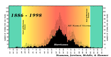
13. graph of hurricane dates/season (need glasses,can anyone read dates?)
Edited on Wed May-09-07 10:58 AM by uppityperson


http://www.aoml.noaa.gov/hrd/tcfaq/G1.html
The Atlantic hurricane season is officially from 1 June to 30 November. There is nothing magical in these dates, and hurricanes have occurred outside of these six months, but these dates were selected to encompass over 97% of tropical activity.


http://www.thestormtrack.com/2007/05/an_early_start_to_the_season.php
8PM EDT UPDATE: I was just looking at some observations from a buoy that is located about 180 miles east of Cape Hatteras, North Carolina. Winds at this buoy have been above tropical storm strength (>39 mph) throughout the day.

The interesting thing to me though are the wave heights. Operationally, NHC warns of a 12-ft wave height radius for named systems, that is how far from the center of the storm does one find 12-ft high waves. Have a look below at the wave heights generated by this system. Pretty impressive.

Alas, looking at the latest model runs, this is most likely the height of the storm's intensity, so if NHC has not upgraded the system yet, it most likely will not. Still, this storm will be a significant rain/wind/surge event for the Southeast Coast, with hurricane force wind warnings posted off the South Carolina coast. If anything else happens with the storm, we'll try to get it posted here.
http://www.thestormtrack.com/WaveHt_8May07_0z.bmp
Printer Friendly | Permalink |  | Top
 
muriel_volestrangler Donating Member (1000+ posts) Send PM | Profile | Ignore Wed May-09-07 11:16 AM
Response to Reply #13
15. Left-hand-most date is "May 1"
then May 10, May 20, June 1, June 10, etc. So the green area is outside the official hurricane season. You can see there are very occasionally hurricanes around May 20, and there was one (hurricane? named storm? I can't tell) before May 10, in those hundred and a bit years.
Printer Friendly | Permalink |  | Top
 
uppityperson Donating Member (1000+ posts) Send PM | Profile | Ignore Wed May-09-07 09:26 PM
Response to Reply #15
41. Thank you. I needed a magnifying glass.
Printer Friendly | Permalink |  | Top
 
Heidi Donating Member (1000+ posts) Send PM | Profile | Ignore Wed May-09-07 12:42 PM
Response to Original message
17. Kick.
:kick:
Printer Friendly | Permalink |  | Top
 
Junkdrawer Donating Member (1000+ posts) Send PM | Profile | Ignore Wed May-09-07 12:42 PM
Response to Original message
18. First named '07 Atlantic storm forms near coast
Source: MSNBC

MIAMI - Subtropical Storm Andrea formed Wednesday off the southeastern U.S. coast, more than three weeks before the official start of the Atlantic hurricane season, forecasters said.

The year’s first named storm had top sustained winds near 45 mph and was centered about 140 miles southeast of Savannah, Ga., at 11 a.m. ET, the National Hurricane Center said. The storm was moving west at about 3 mph.

....

And Andrea's formation follows predictions that 2007 will be an active year.

Private and university forecasters have predicted that the 2007 season that starts June 1 and ends Nov. 30 will be especially active, producing up to 17 tropical storms and hurricanes and a "well above average" possibility of at least one striking the U.S. The federal government plans to release its predictions May 22.

....


Read more: http://www.msnbc.msn.com/id/18573390/


I think this year may be a bad one....
Printer Friendly | Permalink |  | Top
 
SteppingRazor Donating Member (1000+ posts) Send PM | Profile | Ignore Wed May-09-07 12:42 PM
Response to Reply #18
19. Bring it!
I got two bags of ice; four jugs of water; a case and a half of beer; a whole barful of whiskey, tequila and vodka; a newly purchased gas grill with an extra tank; and a freezerful of meat that I'll have to grill before it goes bad.

I am ready!
Printer Friendly | Permalink |  | Top
 
Virginia Dare Donating Member (1000+ posts) Send PM | Profile | Ignore Wed May-09-07 12:42 PM
Response to Reply #19
20. That should last you what, about 24 hours?
B-)
Printer Friendly | Permalink |  | Top
 
SteppingRazor Donating Member (1000+ posts) Send PM | Profile | Ignore Wed May-09-07 12:42 PM
Response to Reply #20
22. Eh, maybe. I give it more like about 12 or so.
:evilgrin:

Printer Friendly | Permalink |  | Top
 
mediawatch Donating Member (224 posts) Send PM | Profile | Ignore Wed May-09-07 12:42 PM
Response to Reply #19
21. at least you have a good attitude
I love FLA and would love to move there one day. I just hope it is still there when I am ready.

My brother lives in Deerfield beach; he was complaining about is hurricane insurance doubling. Oh well stay safe
Printer Friendly | Permalink |  | Top
 
SteppingRazor Donating Member (1000+ posts) Send PM | Profile | Ignore Wed May-09-07 12:42 PM
Response to Reply #21
23. It's one of those "you either laugh or cry" deals.
Hurricane season is going to happen. You certainly can't pick up your house and move it, so you have to deal with the hurricanes. You can either give in to despair or have a hurricane party. I choose the latter.
Printer Friendly | Permalink |  | Top
 
ellenfl Donating Member (1000+ posts) Send PM | Profile | Ignore Wed May-09-07 12:42 PM
Response to Reply #23
27. can't argue with that! i hope the rest of this year's storms
head north like this one.

ellen fl
Printer Friendly | Permalink |  | Top
 
Dr.Phool Donating Member (1000+ posts) Send PM | Profile | Ignore Wed May-09-07 02:17 PM
Response to Reply #19
35. You're gonna need help
What time should I be over?
Printer Friendly | Permalink |  | Top
 
ohio2007 Donating Member (1000+ posts) Send PM | Profile | Ignore Wed May-09-07 12:42 PM
Response to Reply #18
24. Florida needs a good soaking as well as the firelands of Georgia.
Looks like it will be a very wet weekend in Daytona Beach as the storm track indicates
Printer Friendly | Permalink |  | Top
 
SteppingRazor Donating Member (1000+ posts) Send PM | Profile | Ignore Wed May-09-07 12:42 PM
Response to Reply #24
28. Yeah, I'll take the rain a hurrican brings...
it's the 100 mph winds I have a problem with.
Printer Friendly | Permalink |  | Top
 
ohio2007 Donating Member (1000+ posts) Send PM | Profile | Ignore Wed May-09-07 12:46 PM
Response to Reply #28
30. it's a catagory 2 hurricane
sub tropical storm is winds under 70 mph. I don't think it will gain hurricane force.
Printer Friendly | Permalink |  | Top
 
SteppingRazor Donating Member (1000+ posts) Send PM | Profile | Ignore Wed May-09-07 12:47 PM
Response to Reply #30
31. Yeah, I know. I was speaking generally, not this specific storm.
Printer Friendly | Permalink |  | Top
 
Rev. Mother Ramallo Donating Member (103 posts) Send PM | Profile | Ignore Wed May-09-07 12:42 PM
Response to Reply #18
25. Isn't this awfully early?
Printer Friendly | Permalink |  | Top
 
SteppingRazor Donating Member (1000+ posts) Send PM | Profile | Ignore Wed May-09-07 12:42 PM
Response to Reply #25
26. A bit. Hurricane season officially starts June 1
There's been much earlier storms in previous years, though. It's unusual, but not ridiculously so.
Printer Friendly | Permalink |  | Top
 
ohio2007 Donating Member (1000+ posts) Send PM | Profile | Ignore Wed May-09-07 12:49 PM
Response to Reply #26
32. This one didn't spawn off the tropical African coast
it's not the same type of storm. SOmeone pointed out that it is more like a winter pattern 'noreaster
Printer Friendly | Permalink |  | Top
 
ChiciB1 Donating Member (1000+ posts) Send PM | Profile | Ignore Wed May-09-07 01:26 PM
Response to Reply #26
33. True... But I Cut Back On My Home-Owner's Insurance Because It
cost too much money! I have been thinking this year may be very bad. We've had so little rain, NO WINTER at all and now we're getting hit with FIRE!

All I can do is sit and wait!!
Printer Friendly | Permalink |  | Top
 
MsFlorida Donating Member (370 posts) Send PM | Profile | Ignore Wed May-09-07 12:42 PM
Response to Reply #18
29. Just another day in paradise....
n/t
Printer Friendly | Permalink |  | Top
 
jollyreaper2112 Donating Member (955 posts) Send PM | Profile | Ignore Wed May-09-07 02:08 PM
Response to Original message
34. Bugger me sideways with a watermellon
I've lived in Florida all my damn life and I've seen more storms in recent years than all the other years put together!

I think I need to go from a house to an air-conditioned tent, I can always fold that up when a storm's coming.
Printer Friendly | Permalink |  | Top
 
hedgehog Donating Member (1000+ posts) Send PM | Profile | Ignore Wed May-09-07 02:20 PM
Response to Reply #34
36. You might be on to something provided you have a secure place to
store your stuff when the time comes!
Printer Friendly | Permalink |  | Top
 
jollyreaper2112 Donating Member (955 posts) Send PM | Profile | Ignore Wed May-09-07 02:41 PM
Response to Reply #36
38. ha!
The reason for the tent: you can drive away!

Never understood why mobile homes couldn't be moved anywhere. As a kid I always thought the idea was that if trouble was coming, you could up and leave!
Printer Friendly | Permalink |  | Top
 
hedgehog Donating Member (1000+ posts) Send PM | Profile | Ignore Wed May-09-07 03:01 PM
Response to Reply #38
40. Getting up and leaving is a good idea provided
Edited on Wed May-09-07 03:02 PM by hedgehog
1. you have the means, are able to do so and have a place to go (not too poor to afford transportation and not too sick to move)

2. 6 million other people don't get the same idea at the same time.

People talk about evacuating the Gulf Coast, but how will Long Island handle the next hurricane that heads that direction?
Printer Friendly | Permalink |  | Top
 
RL3AO Donating Member (1000+ posts) Send PM | Profile | Ignore Wed May-09-07 02:56 PM
Response to Original message
39. Good. Florida needs the rain.
Printer Friendly | Permalink |  | Top
 
RL3AO Donating Member (1000+ posts) Send PM | Profile | Ignore Wed May-09-07 10:06 PM
Response to Original message
42. Andrea is struggling. Lets see how it goes now that diurnal minimum has passed.
Edited on Wed May-09-07 10:09 PM by RL3AO
Printer Friendly | Permalink |  | Top
 
RL3AO Donating Member (1000+ posts) Send PM | Profile | Ignore Fri May-11-07 05:28 PM
Response to Original message
43. After being called dead, Andrea trying to plan a comeback tour.
Looking very good. Might be fully tropical this time. Advisories may be re-initiated by Saturday morning.

Printer Friendly | Permalink |  | Top
 
DU AdBot (1000+ posts) Click to send private message to this author Click to view 
this author's profile Click to add 
this author to your buddy list Click to add 
this author to your Ignore list Tue Apr 30th 2024, 04:58 PM
Response to Original message
Advertisements [?]
 Top

Home » Discuss » Latest Breaking News Donate to DU

Powered by DCForum+ Version 1.1 Copyright 1997-2002 DCScripts.com
Software has been extensively modified by the DU administrators


Important Notices: By participating on this discussion board, visitors agree to abide by the rules outlined on our Rules page. Messages posted on the Democratic Underground Discussion Forums are the opinions of the individuals who post them, and do not necessarily represent the opinions of Democratic Underground, LLC.

Home  |  Discussion Forums  |  Journals |  Store  |  Donate

About DU  |  Contact Us  |  Privacy Policy

Got a message for Democratic Underground? Click here to send us a message.

© 2001 - 2011 Democratic Underground, LLC