Democratic Underground Latest Greatest Lobby Journals Search Options Help Login
Google

Disturbing new data from the latest Frances advisory (11:00pm EST)....

Printer-friendly format Printer-friendly format
Printer-friendly format Email this thread to a friend
Printer-friendly format Bookmark this thread
This topic is archived.
Home » Discuss » Archives » General Discussion (Through 2005) Donate to DU
 
Media_Lies_Daily Donating Member (1000+ posts) Send PM | Profile | Ignore 
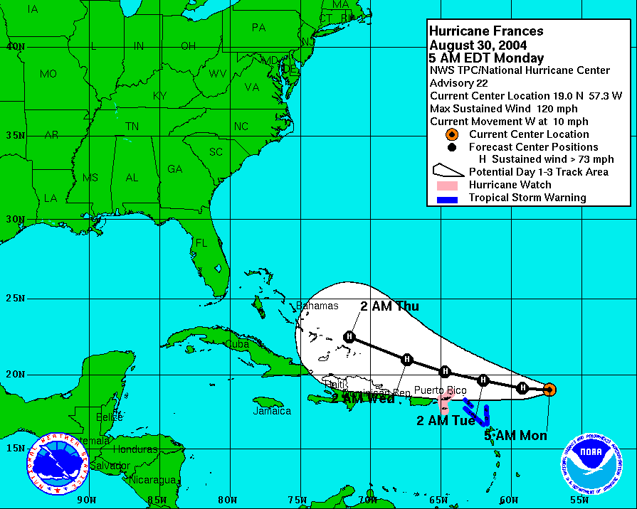
Wed Sep-01-04 10:33 PM
Original message
Disturbing new data from the latest Frances advisory (11:00pm EST)....
Hurricane FRANCES
<http://www.nhc.noaa.gov/text/refresh/MIATCDAT1+shtml/020225.shtml?>

Excerpt:

"HOWEVER...WITH HIGH PRESSURE LOCATED TO THE
NORTHWEST OF FRANCES...I WOULD NOT BE SURPRISED TO THE 00Z MODEL
TRACKS SHIFT A LITTLE MORE WESTWARD.

FRANCES IS EXPECTED TO MOVE OVER WARMER WATER NEAR AND WITHIN THE
BAHAMA ISLANDS CHAIN IN 24-48 HOURS. GIVEN THE ALREADY IMPRESSIVE
OUTFLOW PATTERN...SOME ADDITIONAL STRENGTHENING SEEMS PLAUSIBLE.
ALSO...THE VERY DRY MID-LEVEL AIR...30-40 PERCENT HUMIDITY...THAT
FRANCES HAS BEEN TRAVERSING THROUGH AND INGESTING OVER THE PAST 5
DAYS IS FORECAST TO INCREASE TO MORE THAN 60 PERCENT IN 36-60HR...
WHICH MAY ALSO HELP WITH THE INTENSIFICATION PROCESS."

=======================================================

My comments:

1. A track moving more to the west definitely means a Florida landfall, and sooner rather than later.

2. The warmer water near and within the Bahama Island chain will be followed by the even warmer water of the Gulf Stream...more fuel to the fire.

3. If Frances has developed this well using very dry air at the mid-levels, I can only guess what Frances will do with a mix of more humid air.

My summary:

Warmer water, more humidity in the air-flow at mid-level, and a more westward track allowing Frances to STAY over areas of warmer water can only result in one thing. Frances will be a stronger, perhaps even intensifying, hurricane at landfall...possibly even a Category Five.


Printer Friendly | Permalink |  | Top
wyethwire Donating Member (648 posts) Send PM | Profile | Ignore Wed Sep-01-04 10:34 PM
Response to Original message
1. what's the air pressure at the eye?
Printer Friendly | Permalink |  | Top
 
wyethwire Donating Member (648 posts) Send PM | Profile | Ignore Wed Sep-01-04 10:37 PM
Response to Reply #1
4. pressure now at 939 mb
Printer Friendly | Permalink |  | Top
 
wyethwire Donating Member (648 posts) Send PM | Profile | Ignore Wed Sep-01-04 10:38 PM
Response to Reply #4
6. Hurricane Andrew was at 922 mb
Frances is coming close to that. The lower the pressure the stronger the storm
Printer Friendly | Permalink |  | Top
 
wyethwire Donating Member (648 posts) Send PM | Profile | Ignore Wed Sep-01-04 10:49 PM
Response to Reply #1
11. compare Andrew with Frances
Andrew


Frances

Printer Friendly | Permalink |  | Top
 
FlaIndie Donating Member (266 posts) Send PM | Profile | Ignore Wed Sep-01-04 10:35 PM
Response to Original message
2. Well, I'm screwed
Luckily I live inland so I just have to worry about flooding and power outages. Hopefully those on the coast will make it to safety.
Printer Friendly | Permalink |  | Top
 
tlcandie Donating Member (1000+ posts) Send PM | Profile | Ignore Thu Sep-02-04 09:01 AM
Response to Reply #2
38. If you didn't get to see the damage done in Orlando from the west
coast one recently, you might rethink the, "thank god I'm inlnad", statement.

HUGE trees taken down in Orlando. LARGE roof tiles taken off hotel buildings. I'm not sure what other damage, but it was amazing how much damage there was in Orlando!

This storm appears to be as wide as the whole state of Florida!
Printer Friendly | Permalink |  | Top
 
Jack_Dawson Donating Member (1000+ posts) Send PM | Profile | Ignore Thu Sep-02-04 11:54 AM
Response to Reply #38
61. Gas up!
Unless you wanna wait in long-ass lines.
Printer Friendly | Permalink |  | Top
 
miamimama Donating Member (127 posts) Send PM | Profile | Ignore Wed Sep-01-04 10:36 PM
Response to Original message
3. Shit
Another sleepless night

Thanks for the good news.
Printer Friendly | Permalink |  | Top
 
jpak Donating Member (1000+ posts) Send PM | Profile | Ignore Wed Sep-01-04 10:38 PM
Response to Original message
5. I have a really really bad feeling about this one.
If it crosses the FL Peninsula and gets into the Gulf, the FL Panhandle could get hammered as well.

The double whammy.


Printer Friendly | Permalink |  | Top
 
kestrel91316 Donating Member (1000+ posts) Send PM | Profile | Ignore Wed Sep-01-04 10:43 PM
Response to Reply #5
8. Or it could head on over to New Orleans (cringe) n/t
Printer Friendly | Permalink |  | Top
 
eleny Donating Member (1000+ posts) Send PM | Profile | Ignore Wed Sep-01-04 10:41 PM
Response to Original message
7. Latest image at the Central Florida Hurricane Center web site
Printer Friendly | Permalink |  | Top
 
Roon Donating Member (1000+ posts) Send PM | Profile | Ignore Wed Sep-01-04 10:45 PM
Response to Reply #7
9. That eye is incredible. eom
Printer Friendly | Permalink |  | Top
 
BiggJawn Donating Member (1000+ posts) Send PM | Profile | Ignore Wed Sep-01-04 10:46 PM
Response to Reply #7
10. That is ONE tightly-wrapped storm!
And already 27.6" Hg in the eye....

I have only one baraometer that registers that low out of 20.
(and you thought I collected just bikes)
Printer Friendly | Permalink |  | Top
 
johnfunk Donating Member (1000+ posts) Send PM | Profile | Ignore Wed Sep-01-04 10:52 PM
Response to Original message
12. God really seems to have it in for Jebbie's Florida; my relatives there...
... have already battened down and secured their home, packed their stuff (and their two cats) and headed to stay with family in Pennsylvania for the week.

Needless to say, I was sort of joking with them a few days ago about "catblogging" the storm until it started to look this bad...
Printer Friendly | Permalink |  | Top
 
chefgirl Donating Member (1000+ posts) Send PM | Profile | Ignore Wed Sep-01-04 10:52 PM
Response to Original message
13. Doesn't look good
The following is an email I recieved tonight from a friend who works for TEMA: (Tennessee div. of FEMA)


This information came
from FEMA, TEMA, South Eastern Regional EOC, National
Hurricane Center, and NOAA.

The hurricane that is coming to FL area is going to be
the most destructive hurricane in the history of this
country. The only one that we have found in the
history of this country that even comes close to this
one hit in 1900 and killed 6000 people. We are now
evacuating the entire state of FL. States that will be
affected are GA, FL, NC, SC, and AL. We are looking at
evacuating more than 4.3 million people. And possibly
as many as 6 million people. The sections listed above
have predicted this hurricane to be the biggest
disaster to ever hit this COUNTRY. So please, if
you have family in any of these states please tell
them to evacuate as soon as possible.

Sincerely and safest wishes,

******* * ****

Operations Officer 2

Tennessee Emergency Management Agency (TEMA)


Printer Friendly | Permalink |  | Top
 
walldude Donating Member (1000+ posts) Send PM | Profile | Ignore Wed Sep-01-04 11:02 PM
Response to Reply #13
14. Man time to get on the phone
My mom and sister are in South Florida. My home was destroyed in hurricane Andrew, after that I moved to Colorado, I never wanted to see another hurricane up close again.
So is this "The Day After Tommorow" or what?
Printer Friendly | Permalink |  | Top
 
smallprint Donating Member (778 posts) Send PM | Profile | Ignore Wed Sep-01-04 11:56 PM
Response to Reply #13
16. That's scary.
I haven't heard anything about the entire state of FL being evacuated, though. Seems a bit exaggerated. At least, I hope it is.

:(

Printer Friendly | Permalink |  | Top
 
hang a left Donating Member (1000+ posts) Send PM | Profile | Ignore Thu Sep-02-04 12:42 AM
Response to Reply #13
17. My Grandma is in Florida.
I tried to find this warning. The Tennesse Emergency Management has no such evacuation order on their site. Can you direct me where I should look.
Printer Friendly | Permalink |  | Top
 
Zing Zing Zingbah Donating Member (1000+ posts) Send PM | Profile | Ignore Thu Sep-02-04 01:11 AM
Response to Reply #13
18. They are not evacuating the entire state of Florida...
I think that would be an impossible feat anyhow. Where would all those people go? The news I'm getting over here in Orlando says the hurricane will weaken as it moves across the state. They are figuring it will take at least 24 hours to move from the east coast to the west coast. Currently, they are projecting the landfall to be near Vero Beach at about 140 mph winds. They are figuring 80 mph to 100 mph winds lasting up to 18 hours when it hits Orange County and possibly up to 20 inches of rain. This means big time flooding. It's definitely going to suck.

We are considering going to the Tampa area to stay with my father-in-laws family. It looks like Tampa is not going to be hit as badly as Orlando, plus we are figuring the storm will have weakened a lot by the time it gets to the west coast. Regardless, we figure at least we'd be with family if we went down there.
Printer Friendly | Permalink |  | Top
 
hang a left Donating Member (1000+ posts) Send PM | Profile | Ignore Thu Sep-02-04 01:14 AM
Response to Reply #18
20. You know I hate that.
I read this email. I call my mom, and tell her. She says my uncle is going down to get her. I tell her, like an idiot, that they are evacuating the entire state.

That pisses me off. I can't tell you how many times I have gotten mud on my face from quoting shit people put in posts sometimes. I should know to keep my mouth shut and verify first. But I opened my mouth and verified later.

Somebody slap me.
Printer Friendly | Permalink |  | Top
 
soup Donating Member (1000+ posts) Send PM | Profile | Ignore Thu Sep-02-04 04:00 AM
Response to Reply #20
35. I'm with you on that one.
Almost went into panic mode when I saw it. This storm is the main reason it's a sleepless night here anyway - then to read that?

People in Florida are very watchful and worried about this one. There's a bad feeling in the air and coming in on the heels of hurricane Charley's recent destruction, there's every reason to be concerned.

An elderly neighbor who has lived here in the Tampa Bay area, on the west coast, most of her life has asked my husband to board her windows tomorrow. He told her he didn't think it would be needed, but would take the time to do it if it will make her more comfortable. She's insisting, so he will do it.

This waiting and watching is really nerve-wracking. One of the sites (among many) I moniter during hurricane season is http://flhurricane.com/ There's a lot of good links there, too, for more information. Doesn't look good.

The good news is that your mom will be leaving ahead of it and you know she will be safe. That is all that's important right now. Bunkering in or getting out of harm's way.

Evacuate the entire state? in the next 24 to 48 hours? Yeah, right. :eyes:
Can't even begin to imagine the logistics of that one.

Stay safe everyone. My thoughts are with you.
Printer Friendly | Permalink |  | Top
 
chefgirl Donating Member (1000+ posts) Send PM | Profile | Ignore Thu Sep-02-04 01:44 PM
Response to Reply #35
67. Jeez......sorry folks....
Thought I was being helpful. I DID say that it was an email I had just recieved last night.

I had just gotten home from work, checked email, then logged onto DU and saw this thread. So I passed on what was sent to me.

I never thought to check the veracity of the email. The person who sent it to me DOES indeed work for TEMA and again, I apologize. I never doubted it.

I just got home this afternoon and saw this, and I will do my best to get to the bottom of it.

Meanwhile, I hope everyone stays safe. Sorry for the confusion.


-chef-
Printer Friendly | Permalink |  | Top
 
hang a left Donating Member (1000+ posts) Send PM | Profile | Ignore Thu Sep-02-04 02:27 PM
Response to Reply #67
70. Hi chefgirl

Apology accepted. I perhap vented some penned up anger towards you, and now I am sorry. Hope we can be friends.


:hi:
Printer Friendly | Permalink |  | Top
 
chefgirl Donating Member (1000+ posts) Send PM | Profile | Ignore Thu Sep-02-04 02:39 PM
Response to Reply #70
72. Absolutely
No problem, liberalandproud.

In fact, after reading the replies to my post, I'm feeling a lot of the same anger you probably were last night. I honestly never considered doubting the person that sent me that email, and now I'm pissed as hell.

Didn't mean to panic anyone or pass on bad info.

Friends :hi:

-chef-

Printer Friendly | Permalink |  | Top
 
democratreformed Donating Member (1000+ posts) Send PM | Profile | Ignore Thu Sep-02-04 09:26 AM
Response to Reply #18
45. Take care. I hope that all of ya'll stay safe. n/t
Printer Friendly | Permalink |  | Top
 
SW FL Dem Donating Member (1000+ posts) Send PM | Profile | Ignore Wed Sep-01-04 11:06 PM
Response to Original message
15. I read it the same way.
even worse, it brings me and my family closer to the projected path. We live on the opposite coast, but our school district cancelled school for Friday. To me that is telling. I don't feel good about this one. FL DUers PLEASE get ready!
Printer Friendly | Permalink |  | Top
 
Zing Zing Zingbah Donating Member (1000+ posts) Send PM | Profile | Ignore Thu Sep-02-04 01:25 AM
Response to Reply #15
24. What county / city do you live in?
Edited on Thu Sep-02-04 01:35 AM by babyreblin
I haven't heard of any west coast school cancellations yet. It doesn't necessarily mean they expect your area to be hit very badly. They might be closing the schools so that they can use them as shelters for people evacuating from the east coast. I have heard on the news that some of the shelters used for Charley in central Florida (not sure which ones) cannot be used as shelters this time because they were damaged by Charley.
Printer Friendly | Permalink |  | Top
 
hang a left Donating Member (1000+ posts) Send PM | Profile | Ignore Thu Sep-02-04 01:36 AM
Response to Reply #24
26. I did read when I was googling around.
That South Florida schools will be closed tomorrow. Also courts libraries ect.
Printer Friendly | Permalink |  | Top
 
strategery blunder Donating Member (1000+ posts) Send PM | Profile | Ignore Thu Sep-02-04 01:14 AM
Response to Original message
19. Well, max winds @ 126 kts (145 mph)
Edited on Thu Sep-02-04 01:16 AM by chair094
s***, 10 mph short of Cat 5. Edited to add map, and it looks like it will be a little stronger than forecast, too.

Printer Friendly | Permalink |  | Top
 
Tsiyu Donating Member (1000+ posts) Send PM | Profile | Ignore Thu Sep-02-04 01:20 AM
Response to Reply #19
22. Keep this kicked for our Florida and coastal DUers
:kick:
Printer Friendly | Permalink |  | Top
 
sidestreamer Donating Member (263 posts) Send PM | Profile | Ignore Thu Sep-02-04 01:58 AM
Response to Reply #19
28. Gainesville Resident Reporting:
Most schools in central Florida are closed Friday, and the University of Florida is considering following suit (by later today I expect classes to be cancelled for sure). Brevard County DUers, lurkers, and, heck, even Freepers... brace up, board the windows, get your rations, find the safe place, and if you're religious, have a prayer...
Printer Friendly | Permalink |  | Top
 
PA Democrat Donating Member (1000+ posts) Send PM | Profile | Ignore Thu Sep-02-04 10:20 AM
Response to Reply #19
54. Oh dear God. My brother is in West Palm area n/t
Printer Friendly | Permalink |  | Top
 
Bluebear Donating Member (1000+ posts) Send PM | Profile | Ignore Thu Sep-02-04 01:19 AM
Response to Original message
21. 2 am advisory...strengthening, now 937mb
T 2 AM AST...0600Z...THE CENTER OF SEVERE HURRICANE FRANCES WAS
LOCATED NEAR LATITUDE 22.7 NORTH...LONGITUDE 72.5 WEST OR ABOUT
35 MILES...55 KM...NORTHEAST OF MAYAGUANA ISLAND IN THE BAHAMAS.
THIS IS ALSO ABOUT 555 MILES EAST-SOUTHEAST OF PALM BEACH FLORIDA.

FRANCES IS MOVING TOWARD THE WEST-NORTHWEST NEAR 14 MPH...22 KM/HR
...AND THIS GENERAL MOTION IS EXPECTED TO CONTINUE FOR THE NEXT 24
HOURS. ON THIS TRACK...THE LARGE CORE OF HURRICANE FRANCES WILL BE
MOVING NEAR OR OVER THE SOUTHEASTERN BAHAMAS THIS MORNING...AND NEAR
THE CENTRAL BAHAMAS THIS AFTERNOON AND EVENING.

FRANCES REMAINS A CATEGORY FOUR HURRICANE ON THE SAFFIR-SIMPSON
HURRICANE SCALE. REPORTS FROM AN AIR FORCE RESERVE HURRICANE HUNTER
AIRCRAFT INDICATE THAT MAXIMUM SUSTAINED WINDS HAVE INCREASED TO
NEAR 145 MPH...235 KM/HR...WITH HIGHER GUSTS. FLUCTUATIONS IN
INTENSITY ARE EXPECTED DURING THE NEXT 24 HOURS.

HURRICANE FORCE WINDS EXTEND OUTWARD UP TO 80 MILES...130 KM...
FROM THE CENTER...AND TROPICAL STORM FORCE WINDS EXTEND OUTWARD UP
TO 185 MILES...295 KM.

THE MINIMUM CENTRAL PRESSURE JUST REPORTED BY THE HURRICANE HUNTER
IS 937 MB...27.67 INCHES.

RAINFALL AMOUNTS OF 5 TO 10 INCHES...LOCALLY HIGHER...ARE POSSIBLE
IN ASSOCIATION WITH FRANCES.

STORM SURGE FLOODING OF 6 TO 14 FEET ABOVE NORMAL TIDE LEVELS...
ALONG WITH LARGE AND DANGEROUS BATTERING WAVES...CAN BE EXPECTED
NEAR THE EYE OF FRANCES ON THE WEST SIDE OF ELEUTHRA ISLAND...AND
ON THE NORTH SIDE OF GRAND BAHAMA ISLAND. STORM SURGE FLOODING OF
4 TO 6 FEET ABOVE NORMAL TIDE LEVELS CAN BE EXPECTED ON THE WEST
SIDE OF THE OTHER ISLANDS OF THE BAHAMAS.

REPEATING THE 2 AM AST POSITION...22.7 N... 72.5 W. MOVEMENT
TOWARD...WEST-NORTHWEST NEAR 14 MPH. MAXIMUM SUSTAINED
WINDS...145 MPH. MINIMUM CENTRAL PRESSURE... 937 MB.
Printer Friendly | Permalink |  | Top
 
strategery blunder Donating Member (1000+ posts) Send PM | Profile | Ignore Thu Sep-02-04 01:23 AM
Response to Reply #21
23. Yeah, I noticed the pressure drop, too
I'm watching this closely because 1)my father lives in the Tampa Area and 2)this thing looks big enough to affect the entire state. Though he went to Cocoa Beach for Charley and thought it was "good entertainment."
Printer Friendly | Permalink |  | Top
 
underseasurveyor Donating Member (1000+ posts) Send PM | Profile | Ignore Thu Sep-02-04 01:30 AM
Response to Original message
25. Just caught the rebroadcast of our local 10 pm news
And if I were in Florida, I'd be boarding up and packin'. Frances don't look velly nice, uhuh :-(

Be safe Please :scared:
Printer Friendly | Permalink |  | Top
 
JDPriestly Donating Member (1000+ posts) Send PM | Profile | Ignore Thu Sep-02-04 01:48 AM
Response to Reply #25
27. Is this Florida's retribution
for the part it played in Bush's appointment to the presidency? Why don't we ask Pat Robertson and Falwell? Maybe they know what God is trying to tell Floridians.
Printer Friendly | Permalink |  | Top
 
strategery blunder Donating Member (1000+ posts) Send PM | Profile | Ignore Thu Sep-02-04 02:03 AM
Response to Reply #27
29. I asked this about twelve hours ago
then it hit me that now is not the time to be cracking such jokes. My father lives in Tampa and I won't be able to contact him until probably a week after Frances goes away.:nopity:
Printer Friendly | Permalink |  | Top
 
Zing Zing Zingbah Donating Member (1000+ posts) Send PM | Profile | Ignore Thu Sep-02-04 02:12 AM
Response to Reply #27
30. Floridians aren't the ones to blame
for the 2000 election fiasco. If God was really interested in retribution, I think he'd be specifically targeting Tallahassee and Washington D.C., instead of every place else.

Printer Friendly | Permalink |  | Top
 
underseasurveyor Donating Member (1000+ posts) Send PM | Profile | Ignore Thu Sep-02-04 02:24 AM
Response to Reply #30
31. Yep, it is they that control the machines, the count and their court,
are most definitely the ones to blame, not the people that weren't aware of, the fix is in.

Take Care Floridians. Batten down yer hatches :scared:
Printer Friendly | Permalink |  | Top
 
greekspeak Donating Member (1000+ posts) Send PM | Profile | Ignore Thu Sep-02-04 11:05 AM
Response to Reply #30
58. Hey! Leave Tallahassee out of this!
I don't want my ass kicked by Frances!
Printer Friendly | Permalink |  | Top
 
MirrorAshes Donating Member (942 posts) Send PM | Profile | Ignore Thu Sep-02-04 02:27 AM
Response to Reply #27
32. You know what? I live in florida, and you can kiss my ass for saying that.
This is going to hurt alot of people. Good people. And badly.
Printer Friendly | Permalink |  | Top
 
opihimoimoi Donating Member (1000+ posts) Send PM | Profile | Ignore Thu Sep-02-04 02:47 AM
Response to Reply #32
33. Its Nature trying to cool off Earth.....we just happen to be living there
my daughter included, Orlando...

She is driving to Chicago to get away for the weekend....
Printer Friendly | Permalink |  | Top
 
MirrorAshes Donating Member (942 posts) Send PM | Profile | Ignore Thu Sep-02-04 02:50 AM
Response to Reply #33
34. Yes, and my job, property, and my life as I know it is in serious danger.
Which is why I reacted so strongly to the previous poster.
Printer Friendly | Permalink |  | Top
 
Puglover Donating Member (1000+ posts) Send PM | Profile | Ignore Thu Sep-02-04 09:41 AM
Response to Reply #34
47. Reread 27.
I think he was being sarcastic....simply referring to Robertsons and Falwalls lunacy...
Printer Friendly | Permalink |  | Top
 
Bridget Burke Donating Member (1000+ posts) Send PM | Profile | Ignore Thu Sep-02-04 09:04 AM
Response to Reply #27
39. Next time there's a big quake out in California.
I'm sure that some will consider it God's vengeance. Will you find that wildly amusing?


Printer Friendly | Permalink |  | Top
 
gardenista Donating Member (1000+ posts) Send PM | Profile | Ignore Thu Sep-02-04 11:52 AM
Response to Reply #27
60. This is no better than Jerry Falwell saying the gays and liberals of NY
deserved 9/11.
Printer Friendly | Permalink |  | Top
 
KoKo Donating Member (1000+ posts) Send PM | Profile | Ignore Thu Sep-02-04 08:19 AM
Response to Original message
36. Kick
:kick:
Printer Friendly | Permalink |  | Top
 
nickinSTL Donating Member (1000+ posts) Send PM | Profile | Ignore Thu Sep-02-04 08:29 AM
Response to Original message
37. man this really sucks
My parents were planning to leave this morning to head for Mobile, Alabama to stay in a hotel, and hope the storm doesn't go there next.

They're in Volusia County, right along the coast. Right where most of the projections show the storm heading. :-(
Printer Friendly | Permalink |  | Top
 
Ripley Donating Member (1000+ posts) Send PM | Profile | Ignore Thu Sep-02-04 09:16 AM
Response to Reply #37
43. If they go...don't swim near the pier.
I'm in alabama and I saw film footage yesterday of the main pier in Gulf Shores Alabama. There were dozens of sharks feeding there. They said there might usually be 6, but they were everywhere...no one knows what attracted them.

I know, another Shark story! But hey, I wouldn't swim with them.

And yes, this storm could hit as far west as Alabama. Back in 1995 Opal ripped up from the Gulf and flooded our area bad.

Your parents should be okay if they leave Mobile by Sunday. Bummer to cut short a trip tho.
Printer Friendly | Permalink |  | Top
 
fishnfla Donating Member (1000+ posts) Send PM | Profile | Ignore Thu Sep-02-04 10:48 AM
Response to Reply #37
57. There are no projections for volusia county, I'm there
right now its to the south, at this point we will just catch the outer edge.

If it turns North, could be trouble, but at this point Volusia cty is not on target
Printer Friendly | Permalink |  | Top
 
nickinSTL Donating Member (1000+ posts) Send PM | Profile | Ignore Thu Sep-02-04 12:26 PM
Response to Reply #57
63. Looks to me like they're evacuating...
From AP (I found this on the news link from www.iwon.com)

"A hurricane warning covered much of the state's eastern coast - about 300 miles from Florida City, near the state's southern tip, to Flagler Beach, north of Daytona Beach...Most of the 1.2 million residents who were told to leave were in South Florida - 300,000 in Palm Beach County, 250,000 in Broward County and 320,000 in Miami-Dade County. To the north, Brevard County told 185,000 residents to leave, and Volusia County told 120,000.
Printer Friendly | Permalink |  | Top
 
fishnfla Donating Member (1000+ posts) Send PM | Profile | Ignore Thu Sep-02-04 02:36 PM
Response to Reply #63
71. There are no mandatory evacuations here at this time
There are voluntary evacuations and people are taking it upon themselves to leave.
Tomorrow morning they will evacuate beachside and portions of the peninsula, as well as mobile home parks, people with special needs.

Portions of Brevard county to the south are under mandatory evacuation and right now I-95 is a mess.

The storm has slowed down and weakened a bit and taken a Northwest turn at latest. the eye is supposed to be reforming
Printer Friendly | Permalink |  | Top
 
tlcandie Donating Member (1000+ posts) Send PM | Profile | Ignore Thu Sep-02-04 09:11 AM
Response to Original message
40. Live 40 minutes nw of Tampa and I'm absolutely clueless about
what to do! The storm looks to be wider than the entire state of Florida and length-wise half the size of the entire state of Florida! I'm thinking when my husband flies home tonight we might be heading out up Hwy. 19 ourseleves.

I'm thinking better safe than sorry. Punta Gorda was NOT good!
Printer Friendly | Permalink |  | Top
 
leftchick Donating Member (1000+ posts) Send PM | Profile | Ignore Thu Sep-02-04 09:21 AM
Response to Reply #40
44. you can never tell with hurricanes what to do....
I was living in TPA-ST Petersburg area when Andrew hit the state. I thought for sure we would get something and we debated leaving as well, though we had no where to go! We ended up getting nothing, not even a brisk breeze! You never know but be prepared! Good luck!
Printer Friendly | Permalink |  | Top
 
jcgadfly Donating Member (1000+ posts) Send PM | Profile | Ignore Thu Sep-02-04 09:12 AM
Response to Original message
41. Family member headed down there (probably)
My brother-in-law is a lineman who just came back to Indiana after restoring power after Charley went through (18 hour shifts).

Looks like he'll get to go out again.

Crap. That's a risky job to begin with. The long shifts don't help.
Printer Friendly | Permalink |  | Top
 
soup Donating Member (1000+ posts) Send PM | Profile | Ignore Thu Sep-02-04 10:18 AM
Response to Reply #41
53. Give him a hug and a big "Thank you!"
for his work after Charley, and if he has to come down again for this one, a thank you in advance.

He's probably more aware than anyone of the importance of getting the power up and running again.

My son is out in the backyard right now making sure there's no branches within 'whipping' distance of our power lines. Our neighbor is out in his backyard doing the same.

Guess I better get out there and help load the branches out to the curb for disposal. - ugh.
Printer Friendly | Permalink |  | Top
 
wickywom Donating Member (383 posts) Send PM | Profile | Ignore Thu Sep-02-04 09:14 AM
Response to Original message
42. Honestly...
If you are thinking about leaving Florida go now.
If it shifts the least bit north every hotel will be booked quickly as GA and SC coasts start leaving.
During Floyd when they finally evacuated the NC beaches there wasn't a hotel available all the way to Tenn.
There were people trapped on the interstates .. it was very nearly an even worse disaster and no one every mentioned it.
Printer Friendly | Permalink |  | Top
 
cmf Donating Member (1000+ posts) Send PM | Profile | Ignore Thu Sep-02-04 09:32 AM
Response to Original message
46. I'm keeping everyone down there
in my prayers. A Cat 5 storm is no joke, especially on the heels of a Cat 4. Hurricanes are unpredictable, so I am still hoping it will change track out to sea.
Printer Friendly | Permalink |  | Top
 
hatrack Donating Member (1000+ posts) Send PM | Profile | Ignore Thu Sep-02-04 09:41 AM
Response to Original message
48. 9/2 8:00 AM AST Update - 470 Miles SE W. Palm Beach - Winds Stronger
EDIT

AT 8 AM AST...1200Z...THE EYE OF HURRICANE FRANCES WAS LOCATED
NEAR LATITUDE 23.2 NORTH...LONGITUDE 73.5 WEST OR ABOUT 80 MILES
...135 KM...SOUTHEAST OF SAN SALVADOR ISLAND IN THE BAHAMAS. THIS
IS ALSO ABOUT 470 MILES...755 KM...EAST-SOUTHEAST OF PALM BEACH
FLORIDA.

FRANCES IS MOVING TOWARD THE WEST-NORTHWEST NEAR 13 MPH...20 KM/HR
...AND THIS MOTION IS EXPECTED TO CONTINUE FOR THE NEXT 24 HOURS.
ON THIS TRACK...THE LARGE CORE OF HURRICANE FRANCES WILL CONTINUE
TO MOVE NEAR OR OVER THE SOUTHEASTERN BAHAMAS THIS MORNING...AND
NEAR THE CENTRAL BAHAMAS THIS AFTERNOON AND EVENING.

FRANCES REMAINS A CATEGORY FOUR HURRICANE ON THE SAFFIR-SIMPSON
HURRICANE SCALE. REPORTS FROM AN AIR FORCE RESERVE HURRICANE HUNTER
AIRCRAFT INDICATE THAT MAXIMUM SUSTAINED WINDS ARE NEAR 145 MPH...
235 KM/HR...WITH HIGHER GUSTS. FLUCTUATIONS IN INTENSITY ARE
EXPECTED DURING THE NEXT 24 HOURS.

HURRICANE FORCE WINDS EXTEND OUTWARD UP TO 80 MILES...130 KM...
FROM THE CENTER...AND TROPICAL STORM FORCE WINDS EXTEND OUTWARD UP
TO 185 MILES...295 KM. SAN SALVADOR IN THE BAHAMAS IS CURRENTLY
REPORTING WINDS TO 52 MPH...83 KM/HR.

THE LATEST MINIMUM CENTRAL PRESSURE REPORTED BY THE HURRICANE HUNTER
IS 939 MB...27.73 INCHES.

EDIT

http://www.nhc.noaa.gov/text/refresh/MIATCPAT1+shtml/021145.shtml?

Please keep an eye on this site - the NHC is posting intermediate updates, and may add additional information as merited.

Good luck to all Floridians!!
Printer Friendly | Permalink |  | Top
 
hatrack Donating Member (1000+ posts) Send PM | Profile | Ignore Thu Sep-02-04 10:16 AM
Response to Reply #48
52. 9/2 11:00 AM AST - Warnings Issued For Florida - Frances Very Strong Cat 4
AT 11 AM AST...1500Z...A HURRICANE WARNING HAS BEEN ISSUED FOR
THE EAST COAST OF FLORIDA FROM FLORIDA CITY NORTHWARD TO FLAGLER
BEACH...INCLUDING LAKE OKEECHOBEE.

AT 11 AM AST...1500Z...A TROPICAL STORM WARNING AND A HURRICANE
WATCH ARE IN EFFECT FOR THE MIDDLE AND UPPER FLORIDA KEYS FROM
SOUTH OF FLORIDA CITY TO THE SEVEN MILE BRIDGE INCLUDING FLORIDA
BAY.

A HURRICANE WARNING REMAINS IN EFFECT FOR THE ALL THE BAHAMAS.

AT 11 AM AST...AST THE HURRICANE WARNING FOR THE TURKS AND CAICOS
ISLANDS HAS BEEN DISCONTINUED.

A HURRICANE WARNING MEANS THAT HURRICANE CONDITIONS ARE EXPECTED
WITHIN THE WARNING AREA WITHIN THE NEXT 24 HOURS. PREPARATIONS TO
PROTECT LIFE AND PROPERTY SHOULD BE RUSHED TO COMPLETION.

AT 11 AM AST...1500Z...THE EYE OF HURRICANE FRANCES WAS LOCATED NEAR
LATITUDE 23.4 NORTH...LONGITUDE 73.9 WEST OR ABOUT 55 MILES...90
KM...SOUTHEAST OF SAN SALVADOR...AND 450 MILES... 725 KM...EAST-
SOUTHEAST OF THE LOWER FLORIDA EAST COAST.

FRANCES IS MOVING TOWARD THE WEST-NORTHWEST NEAR 13 MPH...20 KM/HR.
THIS GENERAL MOTION WITH A TURN TO THE NORTHWEST AND A DECREASE IN
FORWARD SPEED IS EXPECTED DURING THE NEXT 24 HOURS. ON THIS
TRACK...THE CORE OF HURRICANE FRANCES WILL BE MOVING NEAR OR OVER
THE CENTRAL BAHAMAS THIS AFTERNOON AND EVENING.

FRANCES REMAINS A DANGEROUS CATEGORY FOUR HURRICANE ON THE
SAFFIR-SIMPSON HURRICANE SCALE WITH MAXIMUM SUSTAINED WINDS NEAR
145 MPH...230 KM/HR...WITH HIGHER GUSTS. SOME FLUCTUATIONS IN
INTENSITY ARE EXPECTED DURING THE NEXT 24 HOURS.

HURRICANE FORCE WINDS EXTEND OUTWARD UP TO 80 MILES...130 KM...
FROM THE CENTER...AND TROPICAL STORM FORCE WINDS EXTEND OUTWARD UP
TO 185 MILES...295 KM. SAN SALVADOR IN THE BAHAMAS IS CURRENTLY
REPORTING 63 MPH...102 KM/HR.

ESTIMATED MINIMUM CENTRAL PRESSURE IS 939 MB...27.73 INCHES.

EDIT

http://www.nhc.noaa.gov/text/refresh/MIATCPAT1+shtml/021145.shtml
Printer Friendly | Permalink |  | Top
 
Cheswick2.0 Donating Member (1000+ posts) Send PM | Profile | Ignore Thu Sep-02-04 09:41 AM
Response to Original message
49. here is the latest track projection
http://www.nhc.noaa.gov/ftp/graphics/AT06/refresh/AL0604W5+GIF/020903W5.gif

Hurricane force winds are going to hit everyone and everything in florida that I care about with the exception of my friends in Miami. All the theaters I worked at. All the churches I sang at, all the bars we partied at after hell week rehersals. My friends houses.
I am really bummed. I wish I was there to be with them.
Andrew distroyed my marriage, now this one is going to destroy everything else I cared about.
Printer Friendly | Permalink |  | Top
 
Fleshdancer Donating Member (1000+ posts) Send PM | Profile | Ignore Thu Sep-02-04 09:45 AM
Response to Original message
50. Holy CRAP! Twice the size of Hurricane Andrew!
That's what the MSNBC weather guy just said.

:scared:

Please Fl DU'ers, stay safe. Let us know if we can do anything.
Printer Friendly | Permalink |  | Top
 
Heyo Donating Member (1000+ posts) Send PM | Profile | Ignore Thu Sep-02-04 09:53 AM
Response to Original message
51. The 11am discussion is out...
The 11am "Discussion" is out from the NHC site.

Hurricane Frances Discussion Number 35


Statement as of 11:00 am EDT on September 02, 2004


the hurricane remains very well-organized and satellite images
depict a distinct eye and excellent outflow. Dvorak intensity
estimates are 127 knots and this is in agreement with earlier
reconnaissance plane measurements. Initial intensity remains at 125
knots. Another Air Force reconnaissance plane will check the
intensity soon. Some fluctuations in intensity are expected before
landfall but Frances is expected to reach the coast as a major
hurricane.

The most interesting aspect this morning is that the National
Weather Service global forecast system...GFS...and GFDL models have
shifted their tracks a little to the west and are now in better
agreement with the other dynamical models. Now that the reliable
GFS and GFDL are in agreement with the other models...the
confidence in the official forecast is higher. Frances is moving
toward the west-northwest or 295 degrees at 11 knots around the
periphery of the subtropical ridge. All models are holding the
ridge strong and long enough to keep the hurricane on a
west-northwest to northwest track with a decrease in forward speed.
This track would bring the core of the hurricane near the East
Coast of Florida in about 48 hours or so. Because Frances has a
large wind field and the tropical storm force winds are expected to
reach the coast much earlier than the eye...a Hurricane Warning has
been issued for the portions of the Florida East Coast to allow
sufficient time for preparations.

Forecaster Avila

forecast positions and Max winds

initial 02/1500z 23.4n 73.9w 125 kt
12hr VT 03/0000z 24.3n 75.4w 125 kt
24hr VT 03/1200z 25.5n 77.2w 125 kt
36hr VT 04/0000z 26.4n 78.5w 125 kt
48hr VT 04/1200z 27.0n 79.7w 125 kt
72hr VT 05/1200z 28.5n 82.0w 70 kt...inland
96hr VT 06/1200z 30.5n 84.5w 30 kt...inland
120hr VT 07/1200z 34.0n 86.5w 25 kt...inland

Heyo


Printer Friendly | Permalink |  | Top
 
fishnfla Donating Member (1000+ posts) Send PM | Profile | Ignore Thu Sep-02-04 10:40 AM
Response to Original message
55. The forecast models are all in agreement now on the track
1. High pressure ridge will keep her to the south, looking to come ashore around west palm

2. It will strengthen over the gulf stream, beyond a doubt. How much??????

3. The good news is once ashore it will weaken, and the track beyond WPB takes the eye over (relatively) lower population density areas until it hits Central Florida at which point it will weaken to a cat 1.

4. heavy rains may be an issue

5. Just passed over I-95 on my way home, Northbound jammed and slow crawling.

6. Frances blows
Printer Friendly | Permalink |  | Top
 
althecat Donating Member (1000+ posts) Send PM | Profile | Ignore Thu Sep-02-04 03:04 PM
Response to Reply #55
73. Sorry about my North Turn post last night...
At the time the GFS model did show a dramatic variation in path. That said it is now back in line with all the others.

(And please beleive me I am taking this seriously. I was just trying to be helpful.)

al

Printer Friendly | Permalink |  | Top
 
fishnfla Donating Member (1000+ posts) Send PM | Profile | Ignore Thu Sep-02-04 04:49 PM
Response to Reply #73
78. all the computer models are in agreement
they keep changing every 8 hrs.

dont worry about the GFS call, if you read the "discussion" section at NOAA, the forecaster( you could read him agonizing) was worried that the normally reliable gfs and another did not jive with the others, now thay are all for one, but the track changes at every hiccup!

maddening
Printer Friendly | Permalink |  | Top
 
jab105 Donating Member (1000+ posts) Send PM | Profile | Ignore Thu Sep-02-04 10:45 AM
Response to Original message
56. Me and my 100 trees and wood frame house are nervous...
three of these come directly through my area...

Printer Friendly | Permalink |  | Top
 
hang a left Donating Member (1000+ posts) Send PM | Profile | Ignore Thu Sep-02-04 11:40 AM
Response to Original message
59. kick n/t
Printer Friendly | Permalink |  | Top
 
hang a left Donating Member (1000+ posts) Send PM | Profile | Ignore Thu Sep-02-04 12:01 PM
Response to Original message
62. Update 1,000,000 residents ordered to evacuate.
Fla. Orders More Than 1 Million Coastal Residents to Evacuate As Hurricane


Fla. Orders More Than 1 Million Coastal Residents to Evacuate As Hurricane Frances Approaches

Vehicles travel west over the Intracoastal Waterway in Sharpes, Fla., leaving the Cocoa Beach area Thursday, Sept. 2, 2004. Three-quarters of a million people in Florida were told to leave their homes by Thursday afternoon as Hurricane Frances inched toward the U.S. mainland. States of emergency were declared in Georgia and Florida. .(AP Photo/Peter Cosgrove)
09-02-2004 9:10 AM
By TIM REYNOLDS, Associated Press Writer

Listen to audio
PORT ST. LUCIE, Fla. -- More than a million people threatened by Hurricane Frances were told to clear out Thursday, and residents scrambled to board up homes and stock up on water ahead of what could be Florida's mightiest storm in a decade.

A hurricane warning covered much of the state's eastern coast _ about 300 miles from Florida City, near the state's southern tip, to Flagler Beach, north of Daytona Beach.

The warning meant hurricane-force winds of at least 74 mph were likely by midmorning Friday _ three weeks after Hurricane Charley, another Category 4 storm, raked the state's western coast with 145 mph wind, causing billions of dollars in damage and killing 27 people.

Most of the residents who were told to leave were in South Florida _ 300,000 in Palm Beach County, 250,000 in Broward County and 320,000 in Miami-Dade County.


Printer Friendly | Permalink |  | Top
 
nostamj Donating Member (1000+ posts) Send PM | Profile | Ignore Thu Sep-02-04 12:37 PM
Response to Original message
64. as big as Texas...
maybe they are over-hyping but, CNN/MSNBC are calling it the storm of a generation. a 100mi wide path of destruction... no one is really suggesting a turn away from the FL coast.

my folks are on the gulf coast but lucked-out with Charley...

Printer Friendly | Permalink |  | Top
 
Corgigal Donating Member (1000+ posts) Send PM | Profile | Ignore Thu Sep-02-04 12:58 PM
Response to Original message
65. found a java link
that shows the projected path. If you need it,its below.

Florida Du'ers good luck and make your plans now.


http://www.nhc.noaa.gov/archive/2004/FRANCES_graphics.shtml
Printer Friendly | Permalink |  | Top
 
Cheswick2.0 Donating Member (1000+ posts) Send PM | Profile | Ignore Thu Sep-02-04 01:23 PM
Response to Reply #65
66. I wonder if this will advance in the thread
Printer Friendly | Permalink |  | Top
 
lpbk2713 Donating Member (1000+ posts) Send PM | Profile | Ignore Thu Sep-02-04 01:49 PM
Response to Original message
68. There's another big storm off the coast of Africa.
As big or maybe bigger than Frances. I just saw it on the map at the Weather Channel website.

Link: http://www.weather.com/maps/news/atlstorm6/atlanticoceansatellite_large.html
Printer Friendly | Permalink |  | Top
 
laruemtt Donating Member (1000+ posts) Send PM | Profile | Ignore Thu Sep-02-04 02:00 PM
Response to Reply #68
69. holy moly - it's not nice
to tick off mother nature. man, she's mad.
Printer Friendly | Permalink |  | Top
 
strategery blunder Donating Member (1000+ posts) Send PM | Profile | Ignore Thu Sep-02-04 03:08 PM
Response to Reply #68
74. Yeah, but it doesn't look as organized--at least not yet
Intellicast doesn't even have it on it's tropical update.
Printer Friendly | Permalink |  | Top
 
hatrack Donating Member (1000+ posts) Send PM | Profile | Ignore Thu Sep-02-04 04:52 PM
Response to Reply #74
79. I checked NOAA for that sector of the Atlantic
Apparently, it's just a big disorganized mess of clouds at this point, though it's got a fair chance of becoming a tropical wave, which is the next step up the energy scale.

No threat just yet, but it probably wouldn't hurt to keep watching.
Printer Friendly | Permalink |  | Top
 
strategery blunder Donating Member (1000+ posts) Send PM | Profile | Ignore Thu Sep-02-04 07:01 PM
Response to Reply #79
81. It's Tropical Depression Nine now
Edited on Thu Sep-02-04 07:02 PM by chair094
Printer Friendly | Permalink |  | Top
 
Wilber_Stool Donating Member (1000+ posts) Send PM | Profile | Ignore Thu Sep-02-04 03:29 PM
Response to Original message
75. Latest from NOAA
Visible


Infrared

Printer Friendly | Permalink |  | Top
 
hatrack Donating Member (1000+ posts) Send PM | Profile | Ignore Thu Sep-02-04 04:21 PM
Response to Original message
76. 9/2 5:00 PM AST - 375 M From Florida; Max Sustained 140, Press Up Slightly
EDIT

AT 5 PM EDT...2100Z...THE EYE OF HURRICANE FRANCES WAS LOCATED BY
RECONNAISSANCE AIRCRAFT...SURFACE OBSERVATIONS...SATELLITE IMAGES
AND RADAR...NEAR LATITUDE 24.1 NORTH...LONGITUDE 74.8 WEST OR VERY
NEAR SAN SALVADOR AND ABOUT 375 MILES...605 KM...EAST-SOUTHEAST OF
THE LOWER FLORIDA EAST COAST.

FRANCES IS MOVING TOWARD THE NORTHWEST NEAR 10 MPH...17 KM/HR...AND
A NORTHWESTWARD TO WEST-NORTHWESTWARD MOTION WITH SOME DECREASE IN
FORWARD SPEED IS EXPECTED DURING THE NEXT 24 HOURS. ON THIS
TRACK...THE CORE OF HURRICANE FRANCES WILL CONTINUE TO MOVE NEAR OR
OVER THE CENTRAL BAHAMAS TODAY AND WILL MOVE OVER THE NORTHWESTERN
BAHAMAS ON FRIDAY.

MAXIMUM SUSTAINED WINDS ARE NEAR 140 MPH...220 KM/HR...WITH HIGHER
GUSTS. FRANCES REMAINS A DANGEROUS CATEGORY FOUR HURRICANE ON THE
SAFFIR-SIMPSON HURRICANE SCALE. SOME FLUCTUATIONS IN INTENSITY ARE
POSSIBLE DURING THE NEXT 24 HOURS.

HURRICANE FORCE WINDS EXTEND OUTWARD UP TO 80 MILES...130 KM...
FROM THE CENTER...AND TROPICAL STORM FORCE WINDS EXTEND OUTWARD UP
TO 185 MILES...295 KM.

ESTIMATED MINIMUM CENTRAL PRESSURE IS 946 MB...27.93 INCHES. SAN
SALVADOR JUST REPORTED A PRESSURE OF 948 MB...27.99 INCHES.

EDIT

http://www.nhc.noaa.gov/text/refresh/MIATCPAT1+shtml/022038.shtml?
Printer Friendly | Permalink |  | Top
 
hang a left Donating Member (1000+ posts) Send PM | Profile | Ignore Thu Sep-02-04 04:43 PM
Response to Original message
77. UPDATE new evacuation ordersFlorida Orders 2.5 Million Residents to Evacua

Florida Orders 2.5 Million Residents to Evacuate Atlantic Coast As Hurricane Frances Approaches

Jennie Amsel, 104, far left, and Patricia Henkel, third from left, are helped to awaiting ambulances that will evacuate them from a Miami Beach, Fla., assisted living facility, Thursday, Sept. 2, 2004, by unidentified workers. More than a million people threatened by Hurricane Frances were told to evacuate Thursday (AP Photo/Bill Cooke)
09-02-2004 2:22 PM
By TIM REYNOLDS, Associated Press Writer

Listen to audio
PORT ST. LUCIE, Fla. -- Residents and tourists in cars, trucks and campers clogged highways Thursday in the biggest evacuation ever ordered in Florida, fleeing inland as mighty Hurricane Frances threatened the state with its second battering in three weeks.

About 2.5 million residents were told to clear out ahead of what could be the most powerful storm to hit Florida in a decade. Other people in the 300-mile stretch covered by the hurricane warning rushed to fortify their homes with plywood and storm shutters, and buy water, gas and canned food.

Already a Category 4 storm with 145-mph winds and the potential to push ashore waves up to 15 feet high, Frances could make itself felt in the state by midmorning Friday.

At 2 p.m. EDT, the hurricane was centered 410 miles southeast of West Palm Beach and was moving at close to 13 mph.


http://sandiego.cox.net/cci/newsnational/national?_mode...


Printer Friendly | Permalink |  | Top
 
althecat Donating Member (1000+ posts) Send PM | Profile | Ignore Thu Sep-02-04 06:11 PM
Response to Original message
80. A close up look at the GFS model track predictions - just posted on scoop
Note the warning from the NHWC forecaster "ALL TRACK MODELS INCLUDING THE GFDL AND THE GFS ARE NOW
IN VERY GOOD AGREEMENT...INCREASING THE CONFIDENCE IN THE FORECAST.
DESPITE THE HIGH CONFIDENCE...IT IS IMPOSSIBLE TO PREDICT THE EXACT
LOCATION OF WHERE THE CENTER WILL CROSS THE COAST THIS FAR IN
ADVANCE."


Click below for tracking images from +24 hours to +96 hours including rainfall
http://www.scoop.co.nz/mason/stories/HL0409/S00030.htm
Printer Friendly | Permalink |  | Top
 
strategery blunder Donating Member (1000+ posts) Send PM | Profile | Ignore Thu Sep-02-04 07:05 PM
Response to Original message
82. Latest track info
Printer Friendly | Permalink |  | Top
 
Zech Marquis Donating Member (1000+ posts) Send PM | Profile | Ignore Thu Sep-02-04 07:47 PM
Response to Original message
83. this could really get bad...
I had the bad fortune of Hurricane Isabelle still fresh in my mind from lat September...and that was "only" a category 1 storm. This damn thing is already a 4, could go as high as 5 :scared:

everyone in Florida--even Jeb and his cronies--please make your plans NOW and don't wait until this monste is on top of you! You can rebuild ahouse, businss, etc, but not your lives.
Printer Friendly | Permalink |  | Top
 
hang a left Donating Member (1000+ posts) Send PM | Profile | Ignore Thu Sep-02-04 08:33 PM
Response to Original message
84. kick n/t
Printer Friendly | Permalink |  | Top
 
althecat Donating Member (1000+ posts) Send PM | Profile | Ignore Thu Sep-02-04 08:33 PM
Response to Original message
85. New NASA Image... Looks scary
Edited on Thu Sep-02-04 08:57 PM by althecat


Edited... as the image has been corrected for the curve of the earth

For Big versions see cool images on
http://cimss.ssec.wisc.edu/tropic/
Printer Friendly | Permalink |  | Top
 
althecat Donating Member (1000+ posts) Send PM | Profile | Ignore Thu Sep-02-04 08:41 PM
Response to Reply #85
86. meanwhile heading west towards China and north towards CA
Edited on Thu Sep-02-04 08:42 PM by althecat
22W


and Hurricane Howard (bottom right corner)


Track
Printer Friendly | Permalink |  | Top
 
hang a left Donating Member (1000+ posts) Send PM | Profile | Ignore Thu Sep-02-04 08:44 PM
Response to Reply #86
87. Whoa!
What's that guys name?
Printer Friendly | Permalink |  | Top
 
althecat Donating Member (1000+ posts) Send PM | Profile | Ignore Thu Sep-02-04 08:58 PM
Response to Reply #87
89. Howard
Printer Friendly | Permalink |  | Top
 
Xithras Donating Member (1000+ posts) Send PM | Profile | Ignore Thu Sep-02-04 08:49 PM
Response to Reply #86
88. California has never been hit by a typhoon in recorded history
It's technically not impossible, but they always loose power in the colder Pacific waters as they make their way north. Of course, several tropical storm level typhoon remnant HAVE slammed into SoCal in the past, killing many people...one in the 1930's killed a bunch of people around San Diego. I'd hate to think of the effect that much water would have on SoCal's fire denuded hillsides nowadays.
Printer Friendly | Permalink |  | Top
 
DU AdBot (1000+ posts) Click to send private message to this author Click to view 
this author's profile Click to add 
this author to your buddy list Click to add 
this author to your Ignore list Sat May 04th 2024, 09:34 AM
Response to Original message
Advertisements [?]
 Top

Home » Discuss » Archives » General Discussion (Through 2005) Donate to DU

Powered by DCForum+ Version 1.1 Copyright 1997-2002 DCScripts.com
Software has been extensively modified by the DU administrators


Important Notices: By participating on this discussion board, visitors agree to abide by the rules outlined on our Rules page. Messages posted on the Democratic Underground Discussion Forums are the opinions of the individuals who post them, and do not necessarily represent the opinions of Democratic Underground, LLC.

Home  |  Discussion Forums  |  Journals |  Store  |  Donate

About DU  |  Contact Us  |  Privacy Policy

Got a message for Democratic Underground? Click here to send us a message.

© 2001 - 2011 Democratic Underground, LLC