Democratic Underground Latest Greatest Lobby Journals Search Options Help Login
Google

RITA Graphics Archive- Nat'l Hurricane Ctr - History & Projection (motion)

Printer-friendly format Printer-friendly format
Printer-friendly format Email this thread to a friend
Printer-friendly format Bookmark this thread
This topic is archived.
Home » Discuss » Archives » General Discussion (Through 2005) Donate to DU
 
tiptoe Donating Member (1000+ posts) Send PM | Profile | Ignore Wed Sep-21-05 02:17 AM
Original message
RITA Graphics Archive- Nat'l Hurricane Ctr - History & Projection (motion)
Edited on Wed Sep-21-05 03:16 AM by tiptoe
"Still" Graphic: Coastal Watches/Warnings and 5-Day Cone - updated every 6 hours


"Motion" Graphic: RITA Graphics Archive - Progression History and Projection...from Tropical Storm to Hurricane...updated

Available Selection & Control Options for 14-progressing-frames at 6-hr intervals
(NEW! Click on the zoom buttons to change the image size)
Select Graphic
Watch/Warn 3-day
Watch/Warn 5-day
Strike Probability
Wind Swaths
Wind Speeds
Wind Table
--------------------------------------------------------------------------------
Loop Images
<< >>
Stop
--------------------------------------------------------------------------------
Adjust Speed
SLOW FAST
--------------------------------------------------------------------------------
Advance One
< >
--------------------------------------------------------------------------------
Zoom
In Out
--------------------------------------------------------------------------------

Map: Texas Cities possibly in path of RITA


Printer Friendly | Permalink |  | Top
craigolemiss Donating Member (223 posts) Send PM | Profile | Ignore Wed Sep-21-05 02:19 AM
Response to Original message
1. the 11 PM
Is a bit faster turn north than the one this afternoon---
Printer Friendly | Permalink |  | Top
 
Up2Late Donating Member (1000+ posts) Send PM | Profile | Ignore Wed Sep-21-05 02:24 AM
Response to Original message
2. Looks like someone at NOAA has too much time on their hands...
...and a bunch of extra computer power.
Printer Friendly | Permalink |  | Top
 
jody Donating Member (1000+ posts) Send PM | Profile | Ignore Wed Sep-21-05 03:53 AM
Response to Original message
3. Thanks.
:hi:
Printer Friendly | Permalink |  | Top
 
intheflow Donating Member (1000+ posts) Send PM | Profile | Ignore Wed Sep-21-05 04:06 AM
Response to Original message
4. Bookmarked and nominated.
I'll bet DU has to shut down many features this weekend, between the storm and the march. It's hard to find stuff like this when the search eature goes down. I want to be sure I can find this thread again.

Great resource, tiptoe. Thanks!
Printer Friendly | Permalink |  | Top
 
tiptoe Donating Member (1000+ posts) Send PM | Profile | Ignore Wed Sep-21-05 12:42 PM
Response to Original message
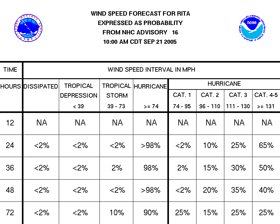
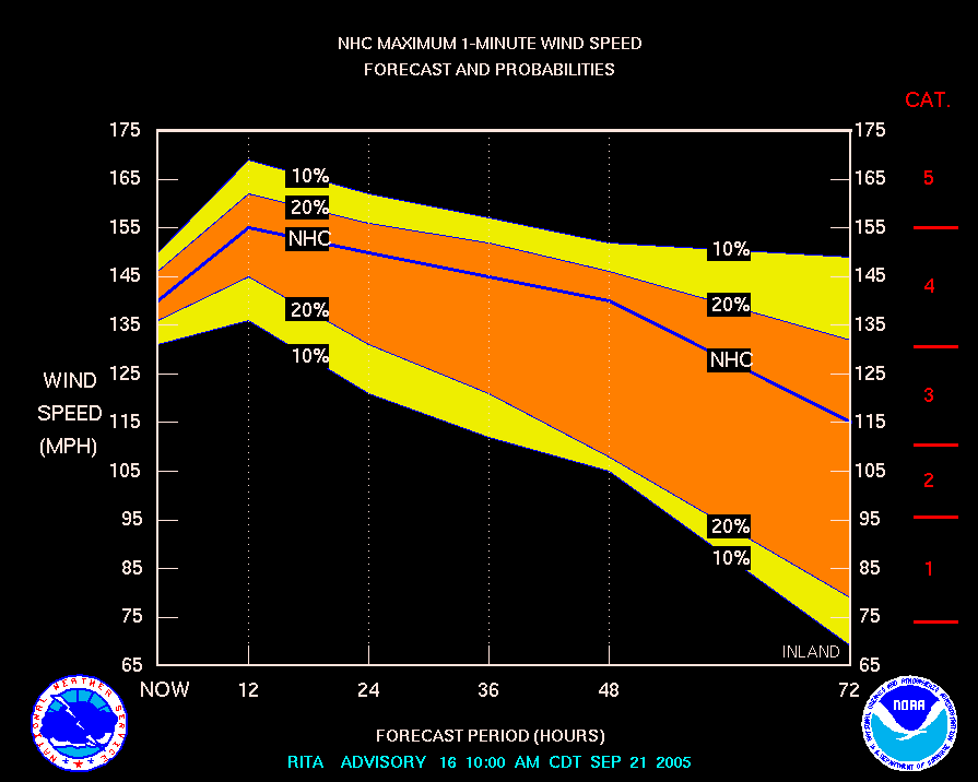
5. RITA- Advisory 16, Wind Speed: 65% 131-160+mph, next 24-hrs (cat 4-5)
Edited on Wed Sep-21-05 12:58 PM by tiptoe


Printer Friendly | Permalink |  | Top
 
Jane Austin Donating Member (1000+ posts) Send PM | Profile | Ignore Wed Sep-21-05 01:32 PM
Response to Original message
6. Thanks for those graphics.
Very interesting to study.
Printer Friendly | Permalink |  | Top
 
tiptoe Donating Member (1000+ posts) Send PM | Profile | Ignore Wed Sep-21-05 02:14 PM
Response to Original message
7. "RITA hits...late FRIDAY night between PORT LAVACA and GALVESTON"
Edited on Wed Sep-21-05 02:42 PM by tiptoe
One expert's prediction
WEDNESDAY: RITA HITS TEXAS LATE FRIDAY NIGHT BETWEEN PORT LAVACA AND GALVESTON AS A CATEGORY 4 OR 5. CARLA'S PRESSURE TO BEAT IS 935. A MAJOR SHOT OF COOL AIR INTO EASTERN THIRD OF THE NATION SIGNALS END OF SUMMER PATTERN.


* HURRICANE RITA - NOW CATEGORY 5 - URGENT UPDATE ** ...SEP 21 2005 - 1:20PM CDT

The latest RECON reports confirm RITA is now a CATASTROPHIC CATEGORY 5 Hurricane.

Center Pressure is down to 920mb, and MAX Sustained winds of 153KTs at Flight level -- implying 155mph surface winds. with gusts to 175mph.


Map: Port Lavaca and Galveston
Printer Friendly | Permalink |  | Top
 
tiptoe Donating Member (1000+ posts) Send PM | Profile | Ignore Wed Sep-21-05 03:23 PM
Response to Original message
8. Gulf of Mexico-Visible Loop - Satellite Image of RITA
Edited on Wed Sep-21-05 04:01 PM by tiptoe
Gulf of Mexico - Visible Loop - Hurricane Rita

UTC/GMT Conversion

UTC/GMT...EDT...EST CDT...CST MDT..MST PDT...PST
0000.....8 PM.....7 PM.....6 PM.....5 PM.....4 PM
0100.....9 PM.....8 PM.....7 PM.....6 PM.....5 PM
0200....10 PM.....9 PM.....8 PM.....7 PM.....6 PM
0300....11 PM....10 PM.....9 PM.....8 PM.....7 PM
0400.....MIDN....11 PM....10 PM.....9 PM.....8 PM
0500.....1 AM.....MIDN....11 PM....10 PM.....9 PM
0600.....2 AM.....1 AM.....MIDN....11 PM....10 PM
0700.....3 AM.....2 AM.....1 AM.....MIDN....11 PM
0800.....4 AM.....3 AM.....2 AM.....1 AM.....MIDN
0900.....5 AM.....4 AM.....3 AM.....2 AM.....1 AM
1000.....6 AM.....5 AM.....4 AM.....3 AM.....2 AM
1100.....7 AM.....6 AM.....5 AM.....4 AM.....3 AM
1200.....8 AM.....7 AM.....6 AM.....5 AM.....4 AM
1300.....9 AM.....8 AM.....7 AM.....6 AM.....5 AM
1400....10 AM.....9 AM.....8 AM.....7 AM.....6 AM
1500....11 AM....10 AM.....9 AM.....8 AM.....7 AM
1600.....NOON....11 AM....10 AM.....9 AM.....8 AM
1700.....1 PM.....NOON....11 AM....10 AM.....9 AM
1800.....2 PM.....1 PM.....NOON....11 AM....10 AM
1900.....3 PM.....2 PM.....1 PM.....NOON....11 AM
2000.....4 PM.....3 PM.....2 PM.....1 PM.....NOON
2100.....5 PM.....4 PM.....3 PM.....2 PM.....1 PM
2200.....6 PM.....5 PM.....4 PM.....3 PM.....2 PM
2300.....7 PM.....6 PM.....5 PM.....4 PM.....3 PM

Printer Friendly | Permalink |  | Top
 
Field Of Dreams Donating Member (570 posts) Send PM | Profile | Ignore Wed Sep-21-05 03:25 PM
Response to Original message
9. What's the worst case scenario for New Orleans...
if the storm maintains this projected track ... will NO get enough rain to flood?
Printer Friendly | Permalink |  | Top
 
tiptoe Donating Member (1000+ posts) Send PM | Profile | Ignore Wed Sep-21-05 04:50 PM
Response to Reply #9
10. "RITA..landfall on Saturday between PORT O'CONNOR and FREEPORT"
Edited on Wed Sep-21-05 04:55 PM by tiptoe

SEP 21, 2005 / 3:28PM CDT - SPECIAL UPDATE #4

RITA EXTREMELY DANGEROUS CATEGORY 5 - 914MB PRESSURE

The latest RECON, and confirmed measurements from NHC - report RITA's central pressure is now down to 914mb. MAX sustained flight winds are 161Kts, with sustained surface winds of 165mph -=- and gusts to 185mph. The thermal eyewall temp difference is an astounding 21°C The pressure has been dropping at 6mb/hr which may be s some form of record of it's own. Furthermore, there are no signs yet that Rita has finished intensifying.

This places Rita in the top 10 of all-time Atlantic Basin Storms -- and in the top 4 for the Gulf of Mexico.
At it's peak -- Katrina reached 902mb.

Latest numerical guidance continues to show a landfall on Saturday between Port O'Connor and Freeport.

A full update will be sent late tonight -- but brief status reports will be issued as warranted.


Projected Track: Hurricane RITA

MAP: Freeport, TX (West of Port Arthur, Galveston, Houston)
Printer Friendly | Permalink |  | Top
 
tiptoe Donating Member (1000+ posts) Send PM | Profile | Ignore Wed Sep-21-05 08:05 PM
Response to Reply #9
11. "U mmm - NOLA is 'east of the Eye'...which means..."
U mmm - NOLA is 'east of the Eye'

...which means that it will get the south winds and the major
storm surge. Which it can't absorb. No matter if they only have CAT1 winds, there will be a storm surge and a significant rainfall.

I'm in P'cola and we've already had some interesting wind gusts and
a rather sever thunderstorm, likely from the outer bands of Rita.

I think the storm should have been name Margarita since it's headed for Tejas.

(From thread: Just talked to my brother at New Orleans Airport)


Printer Friendly | Permalink |  | Top
 
tiptoe Donating Member (1000+ posts) Send PM | Profile | Ignore Thu Sep-22-05 02:00 AM
Response to Reply #9
13. SEPT 21, 2005 11:10pm CDT Weather Underground: 'The Perfect Storm'
http://www.wunderground.com/blog/SteveGregory/show.html">'The Perfect Storm'
<snip>
Satellite imagery depicts what is now intuitively obvious -- 'The Perfect Storm' -- and it is hard to imagine that the storm can get any stronger -- but there is no particular reason for it weaken unless an eye wall replacement cycle -should begin -- though there are not indications that is imminent.
<snip>
Rita could reach the coast as a CAT 5 hurricane, though a strong CAT 4 seems most probable.. But even if the storm does weaken for any one of the above reasons -- with eye wall replacement being the most probable -- there is no doubt that a CAT 5 Storm Surge will hit the coast. With the still expanding and intensifying circulation field -- the storm may produce a CAT 5 storm surge for a 60-80 mile stretch of coast line from near the point of landfall and extending to the northeast.

A tidal surge of 3-5 feet is expected to reach across to the eastern portions of the Louisiana coast, with a 4-8 ft surge from Marsh Island westward to Port Arthur - and then increasing to 20 feet or more from near Galveston to Freeport.
Printer Friendly | Permalink |  | Top
 
tiptoe Donating Member (1000+ posts) Send PM | Profile | Ignore Thu Sep-22-05 03:45 AM
Response to Reply #9
14. Worst Case Scenario for New Orleans
A Worst-Case Scenario Sept 20, 2005

To: Gentle Readers
From: Patricia Koyce Wanniski
Re: Hurricanes Katrina and Rita

Pity the Gulf Coast. Parts of Biloxi and other areas in Missisippi barely received rebuilding supplies before new weather reports began looking dire. New Orleans Mayor Ray Nagin, who had been encouraging New Orleans residents to return to the 60 percent of the city that is now above water, was forced to announce yesterday a "mandatory" evacuation because of the threat of Hurricane Rita. Speaking at a news conference, Nagin warned, "our levee systems are still in a very weak condition. Our pumping stations are not at full capacity, and any type of storm that heads this way and hits us will put the east bank of Orleans Parish in very significant harm's way. So I'm encouraging everyone to leave." On top of that, Vice Admiral Thad Allen, head of the federal recovery effort, noted that the 911 system was still not fully functional and hospitals and other vital services remained closed.

Thankfully, the current storm track (as of 11:33 am EDT) projects Rita making landfall Saturday morning, somewhere along the Texas coast. However, the computer models can only outline possible outcomes, not predict the future, and come complete with the caveat that "deviations in track and/or intensity from current projections could result in significant differences from the information on this graphic." The danger that the area could be hit again is very real and present. Even if the best case scenario occurs and the storm hits as it is currently projected, the potential for Rita's strengthening over the Gulf waters is high. With current winds of 85 mph, Rita will "quite likely powering up into a major hurricane (winds over 110 miles per hour) by the end of the week," according to weather.com...
<snip>
...If the levees fail once more, New Orleans might never recover.

Say a prayer.

Printer Friendly | Permalink |  | Top
 
tiptoe Donating Member (1000+ posts) Send PM | Profile | Ignore Thu Sep-22-05 03:57 AM
Response to Reply #9
15. "Any storm surge could overwhelm the levees...flood the city again."
Louisiana Governor Declares State Of Emergency
Louisiana Gov. Kathleen Blanco has declared a state of emergency.

Engineers have warned that even a glancing blow to New Orleans and 6 inches of rain could swamp the city's levees.

Gov. Blanco and Mayor Ray Nagin are strongly urging people along the Louisiana coast to be prepared to get out. Nagin said Rita could be "equally dangerous" to New Orleans as Hurricane Katrina, and added the city appears to be on the storm's "wet side." Any storm surge, he said, could overwhelm the levees and flood the city again.

New Orleans is requesting 200 buses to help in a possible evacuation. Residents who have returned have been told to be ready to evacuate again. The buses would start running 48 hours before landfall from the downtown convention center and a stadium in Algiers.

Forecasters at the hurricane center said there's only a 5 percent chance Rita could bring hurricane-force winds back to New Orleans
Printer Friendly | Permalink |  | Top
 
tiptoe Donating Member (1000+ posts) Send PM | Profile | Ignore Thu Sep-22-05 04:19 AM
Response to Reply #9
16. RITA Worst-case for NO: "Landfall just west of where Katrina came ashore"
Edited on Thu Sep-22-05 04:21 AM by tiptoe
New Orleans to stay off-limits originally published Sept 20, 2005
<snip>
The storm was expected to head west-northwest across the gulf for two or three days.

"The track is uncertain after that," <Jack> Beven said. Landfall could occur anywhere from southern Texas to western Louisiana by the weekend.

"That's a pretty broad sweep," he said. "There's a lot of uncertainty on the end of the forecast track."
<snip>
The worst-case scenario for New Orleans would be a landfall just west of where Katrina came ashore on Aug. 29. That would put the city and its weakened levee system in the storm's northeast quadrant, and in its strongest winds and storm surge.
Printer Friendly | Permalink |  | Top
 
CascadeTide Donating Member (164 posts) Send PM | Profile | Ignore Thu Sep-22-05 04:24 AM
Response to Reply #9
17. whatever happens is worst case for new orleans
Much of the city was destroyed and now they're going to have to share the rebuilding efforts with Texas. Guess who's going to get the lions' share of that focus?

I almost think it would be better if the thing hit New Orleans again. Pretty much everyone is gone anyway and, besides wind damage, it can't get much worse. All it would do is set them back a few weeks from returning.
Printer Friendly | Permalink |  | Top
 
tiptoe Donating Member (1000+ posts) Send PM | Profile | Ignore Thu Sep-22-05 12:27 PM
Response to Reply #9
18. "Even if Rita follows its expected route and strikes Galveston, Texas..."
CATEGORY 5 RITA HAS N.O. NERVOUS Times-Picayune Sept 22, 2005
<snip>
...rain and storm surges are possible in New Orleans, which was inundated by Hurricane Katrina and subsequent levee breaks.

Given the possibility of more water for the already saturated city, the Army Corps of Engineers began Wednesday to close with steel sheet pilings the 17th Street and London Avenue canals, both of which were damaged by Hurricane Katrina, to provide protection for those parts of the city. They are to remain closed until the weather threat passes.

In neighboring St. Bernard Parish, Lake Borgne Levee District officials said they are on schedule to complete repairs of the 66-mile levee along the parish's northern and eastern flanks in time to protect against a potential for a 2- to 4-foot storm surge.

In Jefferson Parish, an official said a storm could push a tidal surge of 3 to 5 feet into Barataria Bay and threaten a weak point in the parish's storm defenses: the Harvey Canal levee. Anything over 5 feet could top the levee and cause widespread flooding, emergency management director Walter Maestri said.
<snip>
Printer Friendly | Permalink |  | Top
 
tiptoe Donating Member (1000+ posts) Send PM | Profile | Ignore Thu Sep-22-05 12:35 PM
Response to Reply #9
19. "Gov. Blanco just said Rita may hit New Orleans directly" (DU Threads)
Printer Friendly | Permalink |  | Top
 
tiptoe Donating Member (1000+ posts) Send PM | Profile | Ignore Thu Sep-22-05 01:45 AM
Response to Original message
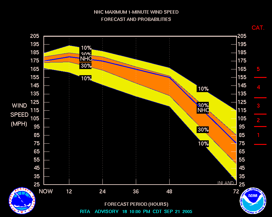
12. RITA - Category 5 - Wind Speed Forecast - 175mph at 10pm CDT Sept 21
Printer Friendly | Permalink |  | Top
 
DU AdBot (1000+ posts) Click to send private message to this author Click to view 
this author's profile Click to add 
this author to your buddy list Click to add 
this author to your Ignore list Wed May 01st 2024, 02:03 AM
Response to Original message
Advertisements [?]
 Top

Home » Discuss » Archives » General Discussion (Through 2005) Donate to DU

Powered by DCForum+ Version 1.1 Copyright 1997-2002 DCScripts.com
Software has been extensively modified by the DU administrators


Important Notices: By participating on this discussion board, visitors agree to abide by the rules outlined on our Rules page. Messages posted on the Democratic Underground Discussion Forums are the opinions of the individuals who post them, and do not necessarily represent the opinions of Democratic Underground, LLC.

Home  |  Discussion Forums  |  Journals |  Store  |  Donate

About DU  |  Contact Us  |  Privacy Policy

Got a message for Democratic Underground? Click here to send us a message.

© 2001 - 2011 Democratic Underground, LLC