| Latest | Greatest | Lobby | Journals | Search | Options | Help | Login |
|
|
|
This topic is archived. |
| Home » Discuss » Topic Forums » September 11 |
|
| Old and In the Way
|
Wed Apr-12-06 12:39 AM Original message |
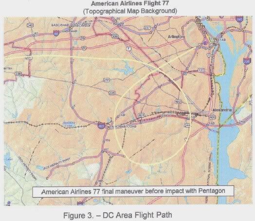
| 77's Washington DC flightpath. |
| Printer Friendly | Permalink | | Top |
| Make7
|
Wed Apr-12-06 01:48 AM Response to Original message |
| 1. The Drawing Board |
| Printer Friendly | Permalink | | Top |
| Old and In the Way
|
Wed Apr-12-06 03:09 AM Response to Reply #1 |
| 3. I think it was easier to post this than try to explain on PM. |
| Printer Friendly | Permalink | | Top |
| Make7
|
Wed Apr-12-06 04:55 AM Response to Reply #3 |
| 4. It does appear that an approach from the NW is incorrect. |
| Printer Friendly | Permalink | | Top |
| Old and In the Way
|
Wed Apr-12-06 05:28 AM Response to Reply #4 |
| 5. Interesting...that really seems more the way I understood it |
| Printer Friendly | Permalink | | Top |
| Yatar
|
Fri Apr-21-06 11:45 AM Response to Reply #4 |
| 14. Did you tape the 9-11 Commission hearings from C-Span? |
| Printer Friendly | Permalink | | Top |
| Make7
|
Sun Apr-23-06 06:34 PM Response to Reply #14 |
| 16. No, I did not tape them. |
| Printer Friendly | Permalink | | Top |
| Jazz2006
|
Wed Apr-12-06 02:10 AM Response to Original message |
| 2. I recall seeing FAA logs published quite some time ago.... |
| Printer Friendly | Permalink | | Top |
| kerry_s
|
Wed Apr-12-06 01:08 PM Response to Original message |
| 6. An another interesting photo |
| Printer Friendly | Permalink | | Top |
| Old and In the Way
|
Wed Apr-12-06 06:41 PM Response to Reply #6 |
| 7. Why would 90 degrees be important in this theory? |
| Printer Friendly | Permalink | | Top |
| bmxeroftruth
|
Sat Apr-15-06 10:38 AM Response to Original message |
| 8. hey |
| Printer Friendly | Permalink | | Top |
| Old and In the Way
|
Sun Apr-16-06 02:44 PM Response to Reply #8 |
| 11. Can you provide a link? nt |
| Printer Friendly | Permalink | | Top |
| Debunking911
|
Sat Apr-15-06 12:05 PM Response to Original message |
| 9. Question... |
| Printer Friendly | Permalink | | Top |
| Old and In the Way
|
Sun Apr-16-06 02:27 PM Response to Reply #9 |
| 10. I think Washington DC is relatively easy to navigate with |
| Printer Friendly | Permalink | | Top |
| kerry_s
|
Fri Apr-21-06 05:20 AM Response to Reply #9 |
| 12. We know that they were confused |
| Printer Friendly | Permalink | | Top |
| MrSammo1
|
Fri Apr-21-06 06:27 AM Response to Original message |
| 13. Listen............ |
| Printer Friendly | Permalink | | Top |
| savemefromdumbya
|
Sun Apr-23-06 06:06 PM Response to Original message |
| 15. Flight 77 did not exist |
| Printer Friendly | Permalink | | Top |
| Make7
|
Sun Aug-13-06 03:21 PM Response to Original message |
| 17. We now have the official flightpath. Just released: |
| Printer Friendly | Permalink | | Top |
| bushatbooker
|
Sun Aug-13-06 03:29 PM Response to Reply #17 |
| 18. Did anybody claim to see it spiral down? |
| Printer Friendly | Permalink | | Top |
| Make7
|
Sun Aug-13-06 03:53 PM Response to Reply #18 |
| 19. I don't know. What does killtown's website and/or blog say? ( n/t ) |
| Printer Friendly | Permalink | | Top |
| bushatbooker
|
Sun Aug-13-06 09:31 PM Response to Reply #19 |
| 21. I didn't see anybody mention they saw it spiral down |
| Printer Friendly | Permalink | | Top |
| Old and In the Way
|
Sun Aug-13-06 09:47 PM Response to Reply #17 |
| 22. Thanks for the PM on this, Make7 |
| Printer Friendly | Permalink | | Top |
| Make7
|
Sun Aug-13-06 10:20 PM Response to Reply #22 |
| 23. No problem - thought you'd be interested that something was released. |
| Printer Friendly | Permalink | | Top |
| Generarth
|
Sun Aug-13-06 09:04 PM Response to Original message |
| 20. My view is that whatever hit the Pentagon took off from Reagan |
| Printer Friendly | Permalink | | Top |
| mirandapriestly
|
Sun Aug-13-06 11:24 PM Response to Original message |
| 24. So.... |
| Printer Friendly | Permalink | | Top |
| DU
AdBot (1000+ posts) |
Mon Apr 29th 2024, 02:35 PM Response to Original message |
| Advertisements [?] |
| Top |
| Home » Discuss » Topic Forums » September 11 |
|
Powered by DCForum+ Version 1.1 Copyright 1997-2002 DCScripts.com
Software has been extensively modified by the DU administrators
Important Notices: By participating on this discussion board, visitors agree to abide by the rules outlined on our Rules page. Messages posted on the Democratic Underground Discussion Forums are the opinions of the individuals who post them, and do not necessarily represent the opinions of Democratic Underground, LLC.
Home | Discussion Forums | Journals | Store | Donate
About DU | Contact Us | Privacy Policy
Got a message for Democratic Underground? Click here to send us a message.
© 2001 - 2011 Democratic Underground, LLC
 >
>  >
>

 (High res)