All depends on where you are. Check out this article from the Sunday Globe - fairly accurate, as far as I can tell, but fellow MA'ers are welcome to weigh in with their personal critiques.
http://www.boston.com/news/globe/ideas/articles/2006/06/04/the_state_im_in/?page=full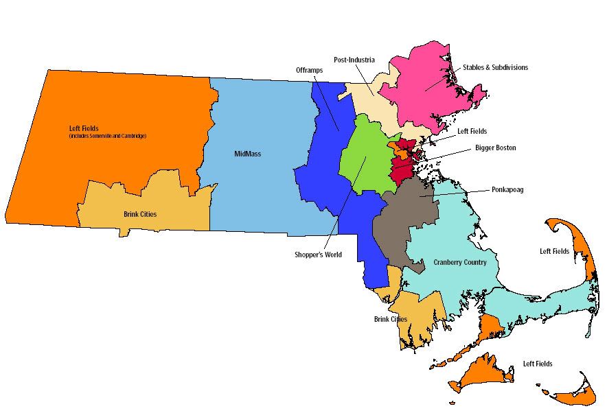
Tay, is your town in the Offramps or Post-Industria? I live in Bigger Boston.
The state I'm in
Politically, Massachusetts is really 10 states, not one.By Robert David Sullivan | June 4, 2006
DESPITE ITS CONSISTENT blue hue on presidential election maps, the political geography of Massachusetts has been remarkably unpredictable during the past few decades. Indeed, the state has often produced a fun-house version of national politics, with liberal Republicans thriving in bohemian towns and conservative Democrats running strongly in family-oriented suburbs.
In the most recent gubernatorial election, in 2002, Mitt Romney embraced the conservative label to a greater degree than his Republican predecessors William Weld and Paul Cellucci, and as a result brought Massachusetts a bit closer to the deep red/blue divisions of national politics: Urban areas became more Democratic while fast-growing exurbs became more Republican. Whether our political geography settles into this more predictable groove, however, is very much an open question.
To demonstrate the shifting priorities and allegiances of Massachusetts voters, CommonWealth magazine divided the state into 10 regions, each representing roughly one-10th of the electorate in the previous gubernatorial election. As the Democrats emerge from their convention this weekend, this map may suggest where they will find surprising pockets of support-and where their influence may be eroding. If the past 25 years are any indication, one of the candidates now vying for the office will need to win at least five of these regions in November to become governor.
A longer version of this article appears in the spring issue of CommonWealth, available online at
http://www.massinc.org/index.php?id=525&pub_id=1847.