| Latest | Greatest | Lobby | Journals | Search | Options | Help | Login |
|
|
|
| Home » Discuss » DU Groups » Recreation & Sports » Bicycling Group |
|
| happyslug
|
Thu Jul-26-07 11:04 AM Original message |
| Bollman Bridge on the Youg Trail is UP |
|
Edited on Thu Jul-26-07 11:19 AM by happyslug
It is NOT finished when these pictures were taken last Sunday (July 22, 2007) but it was up.
Reported in the following Newspapers: http://www.dailyamerican.com/articles/2007/07/23/news/news137.txt (Includes picture of the bridge is going up) http://www.post-gazette.com/pg/07198/802282-100.stm Story of the Bridge at its old location: http://www.meyersdale.org/rr_history/bollman.html  A picture from underneath the Bridge showing its width: 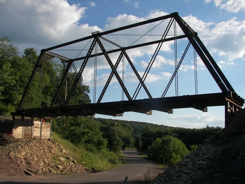 A picture of the Bridge from on top: 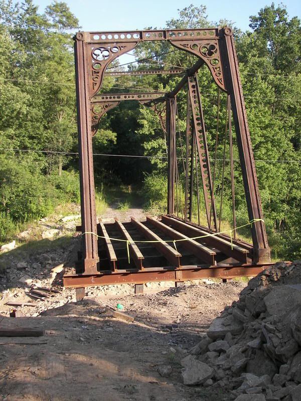 Another Picture showing the dirt that was removed to install the bridge: 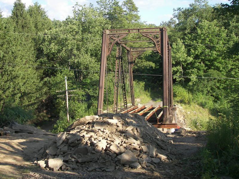 The pier the Bridge is standing on: 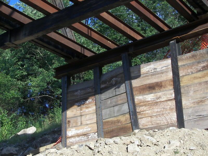 Myersdale is SERIOUS about protecting its trail, they even have a tank to help them defend (The M60 Tank is in front of the VFW club a few blocks away on old 219, but the Gun is pointed in the direction of the Trail) 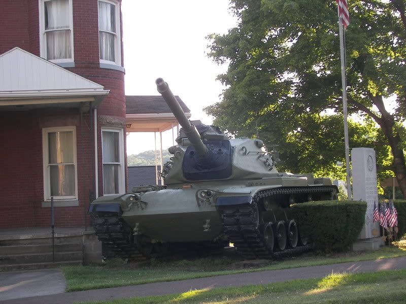 The Path to bypass the Bridge while it was OUT and while it is under-construction. 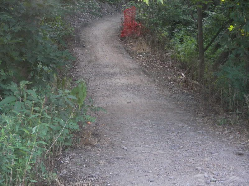 |
| Refresh | 0 Recommendations | Printer Friendly | Permalink | Reply | Top |
| Kolesar
|
Thu Jul-26-07 11:50 AM Response to Original message |
| 1. Wow. Great stuff |
|
Myersdale has a nice website too. I found the link to the story of the Myersdale Viaduct.
|
| Printer Friendly | Permalink | Reply | Top |
| happyslug
|
Fri Jul-27-07 10:02 PM Response to Reply #1 |
| 3. Forgot to mention this is the THIRD LOCATION FOR THIS BRIDGE. |
|
From 1871 till 1910 (one source say 1896) it was a B&O Railroad bridge in Bedford County. The trains became to heavy for the bridge, so in 1910 the bridge was moved and transformed into a Bridge to carry traffic OVER the Railroad just South of Myersdale, Somerset County Pennsylvania. From 1910 till 2003 it did this job over the B&O main line North of Myersdale. In 2003 the State decide to replace the Bridge with a wider modern Concrete Bridge. The Young Trail had a missing link South of Myersdale over Scratch Hill Road.
When the C&O railroad was closed down, the Bridge over Scratch Hill Road had been removed to provide more room for cars and trucks to travel underneath, but it left a huge gap in the trail. The gap was bypassed by a shortcut down to the Scratch Hill Road and them back up to the trail, but something was needed to fill in the trail. When the State decided to replace the Bollman Bridge in 2003 it was offered to the Trail for use. The Trail had to wait a few years to get the money to install the bridge (It had been removed and stored off to the side of the B&O tracks). The original bridge in this spot of the trial had been a huge steel box designed to carry the weight of loaded coal cars, thus it sank over five feet BELOW the trail (and that depth is why the state removed the original bridge when the C&O was abandoned). The Bollman bridge is NOT as strong as the bridge that was removed, but strong enough to carry heavy trucks and its bottom frame does NOT go five feet under the deck of the bridge, thus Scratch Hill Road will still be able to take almost any truck that is legal in PA (Excluding those that require special permits i.e. loads over 16 feet tall). Thus the Bollman Bridge is a good fit for this missing gap in the Trail. More Pictures of the Bridge as a bridge OVER the B&O tracks: http://www.iceandcoal.org/bridges/bollmanmeyersdale/bollmanmeyersdale.html |
| Printer Friendly | Permalink | Reply | Top |
| Gregorian
|
Fri Jul-27-07 09:59 PM Response to Original message |
| 2. What a gorgeous addition to a trail. |
|
It's certainly a bit more articulate than the bridge I made for my local trail here. I'm not totally sure that all of the work warrants it's purpose.
I just got off the phone with my mom. She grew up in Connecticut. I'm at odds with what to do with my life. I love riding bikes. But where I grew up is no longer where I can tolerate to live. We talked about the east coast. I'd love to have another lifetime to discover your area. Thanks for sharing. |
| Printer Friendly | Permalink | Reply | Top |
| happyslug
|
Fri Jul-27-07 11:13 PM Response to Reply #2 |
| 4. This will be the SHORTEST Bridge in this part of the Trail. |
|
This part of the trail starts with the Salisbury Viaduct, the longest Bridge on the trail, it is about 10 miles from the Salisbury Viaduct to the Mt Salvage Tunnel. 14 miles between Myersdale and Frostburg MD.:
 The Trial then goes through Myersdale (Which is build on a hillside): Then you go to the Bollman Bridge, and then to the Keystone Bridge:,   http://www.wmwestsub.com/connellsvillesub/keystoneviaduct.htm You then climb Mt Salvage on a 3% grade to the highest point on the trail (It is a cut, that had been filled in by PENNDOT and now has a small tunnel under the Penndot Road: 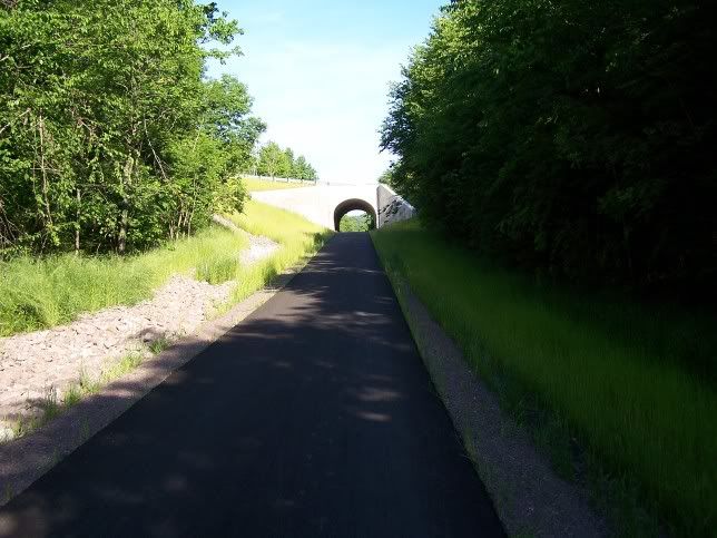 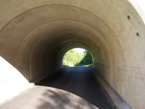 Then to Mt Salvage Tunnel: 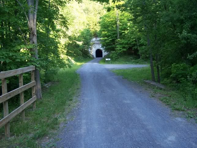 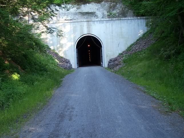 The inside of the Tunnel: 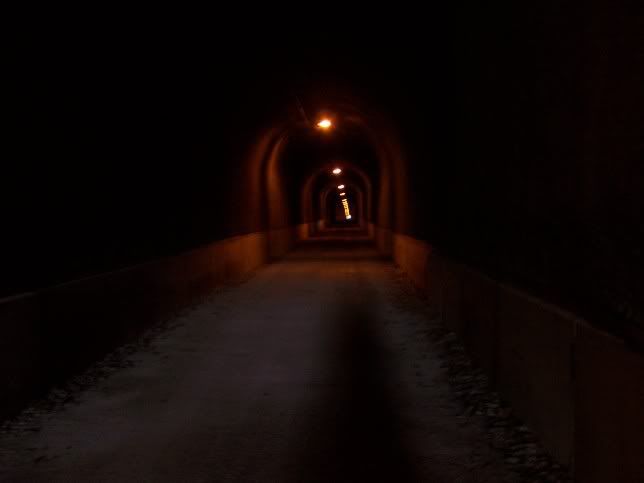  (It is a picture of the INSIDE of a TUNNEL, do not expect to see much): Then you exit the Tunnel (Picture of the Tunnel from the other side: 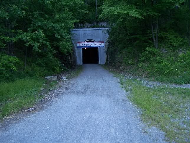 The view from the other side (East Side of the Mountain): The Appalachians Mountains are NOT as tall as the Rockies or those further West, but steep enough for a good view: 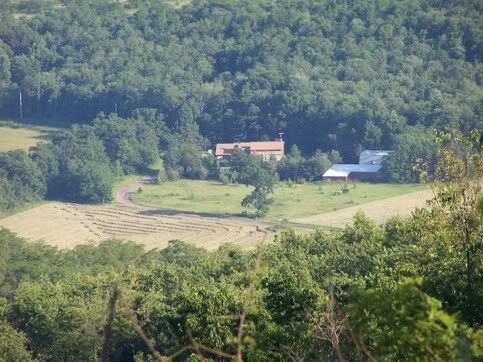 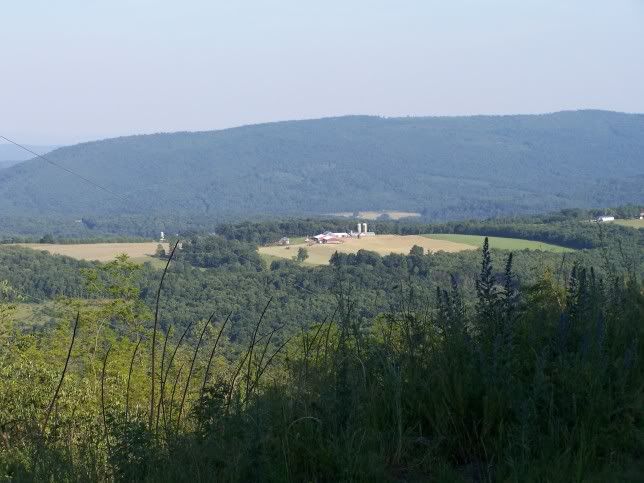 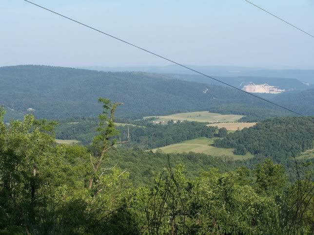 Don't forget to do the original Railroad all of the above had to be built and to have the trial all of the above had to save, converted and rebuilt for the trail to work. You can not Bike across the Appalachians Mountains on your own trail without having to fight traffic (One exception, between Cumberland and Frostburg the Trial shares the path with a Steam tourist Locomotive, runs 3-4 times a day on the week end and will take bikers with their bikes. Other than that clear biking between Washington DC and McKeesport PA (Just south of Pittsburgh, the trail to Pittsburgh is NOT done, bu tit is being worked on). Here is more on the overall Trail: http://www.atatrail.org/ |
| Printer Friendly | Permalink | Reply | Top |
| Gregorian
|
Sat Jul-28-07 12:48 PM Response to Reply #4 |
| 5. That is very nice. |
|
What I see on that website is almost like the world I've been wanting. A way to get from one little town to the other without CARS. I won't ride on the road. And it has made my search for a home almost impossible. But that's another story.
I wish I had a magic transporter. I'd beam myself to the east coast. I'm not the kind of person who travels. I'm not willing to spew co2 into the atmosphere to hop around the planet pleasuring myself. And I get nothing but grief from everyone about it. I didn't go to Russia to visit my cousin in 1980. I didn't go to Mystic to see my mom's house in 1973. I didn't go to the Tour like my friend Tom Ritchey this year. Sorry. That's more than you bargained for. I need a new universe. I don't like this one. And I'm having a hell of a time finding one with real estate prices, lack of inventory of places to buy, and just American society's automotive mentality. Can you tell I'm overwhelmed? I just sold a "Garden of Eden" 65 acre farm because the neighbors were logging everything around me. At 3am. Every day. For two years. And now I'm renting with everything I own in storage, all over the state of California. And I'm trying to figure out where to go. California has nice weather and no mosquitoes. And I don't know the east coast. And I'm not willing to drag my life 3000 miles and discover another mistake. I guess I'm just looking at posts like this as perhaps giving another hint. Another puzzle piece. Oh yeah, and California doesn't have humidity and ice cold winters. But it doesn't have nice bike paths that go through little towns like that. I should just delete this post and say nothing. My head hurts. Literally. |
| Printer Friendly | Permalink | Reply | Top |
| Kolesar
|
Sun Jul-29-07 08:28 PM Response to Reply #5 |
| 6. Colorado is the cycling state |
|
In the towns of Loveland and Ft Collins, they put in enough bike lanes that you could get by with a bicycle. Very good urban planning. However, I think that Colorado is the cycling state on account of bike sales which is largely the recreation of riding in the mountain countryside. Sort of like skiing--it's for fun.
The Allegheny Highlands are quite a beautiful place. I have gone there for all sorts of outdoor fun for several decades. In all honesty, the cycling there is on the rail trails and everything else is about cars. In those small towns, I suppose a few people get their stuff done just walking to the shops and jobs. The region has had a jobs deficit for a long time. Coal is cyclical and the steel industry is weak. Many young people move off for opportunity. Ironically, coal mining is resurgent in that area, which probably does not delight you. I can say that the people I meet around there are a lot of fun and open and friendly. The Pittsburgh and Appalachian accents are entertaining and genuine. I think the places you can get by on transit or your own locomotion are NYC, Chicago, San Francisco and Washington DC. Chicago's El train is in a state of disrepair. DC is still up and coming. Yes, there is spin off economic activity due to government spending, but my impression is that the DC Metro system has been an incredible economic engine. Nothing works like being able to get around. They also have a nice trails system. Some of it actually serves as a commuter bicycle system. Hope this helps. I am kind of bummed hearing about the 65 acre farm. Keep your chin up. |
| Printer Friendly | Permalink | Reply | Top |
| happyslug
|
Sun Jul-29-07 09:21 PM Response to Reply #6 |
| 8. I have heard the same thing about Seattle, but no personal knowledge. |
|
n/t
|
| Printer Friendly | Permalink | Reply | Top |
| happyslug
|
Sun Jul-29-07 08:52 PM Response to Reply #5 |
| 7. You have to make the decision yourself, but think nothing of talking.about it |
|
Edited on Sun Jul-29-07 09:20 PM by happyslug
Some of the best decision ever made was made after PEOPLE TALKED ABOUT IT, both good and bad. Look at the quote at the bottom of my page that was made by a Democratic after a trial, a trial he had won, but a trial he thought of as nothing more then a way to get people TALKING ABOUT WHAT THE TRIAL WAS ABOUT. The speaker of the Quote actually offered to PAY the Defendant's fine, if he needed any help paying it. The punishment awarded by the Trial was MINOR to teh Speaker of the quote (He had lobbied the State Legislature NOT to impose any fine when the law was passed, he wanted people to THINK about the issue not fear it). Getting the SUBJECT debated by the people was the sole object of why he participated in the trial. His point was you can NOT decide anything unless you debate it first. To debate you MUST talk about it, both good and bad. After a good bit of Debate then you will come to the RIGHT decision. It may be to stay in California, or move to some place else, but the right decision can NOT be made unless you talk about it. Talk to your relatives, talk to your friends, and bring it up on this forum, that is why it is here. If you belong to a Church talk to it with your Priest and peopel you meet at church (Or any other social group you may belong to). These peopel who go to the same place you socolise in may say something none of us have even thought of. Talk to people about it. That is the only way you can GET ALL THE INFORMATION so you can make the RIGHT DECISION.
As to this issue, the first issue, in my opinion, is always your Income, you need an income. Family must come second (But not that much second, if you have to chose between Family and Income go with Family i.e. your wife and Children). On the other hand you need income to support yourself and your family. Thus Income and Family are things you have to balance. You need BOTH, but conflicts will arise because you have both. Thus you must balance between the two, but lets first look at Income on this decision (I do not know anything about you, but what your family wants, including your parents and siblings are a factor, but secondary to any children and spouse you may have). As to income I live in Johnstown PA, about 30 miles North of the Youghiogheny Trail. Why? because that is where my Job is. I like to live on the trail, but I can not. Thus the first thing you MUST think of is do you have a Skill you can sell on the East Coast? If yes, then look where on the East coast you can "Sell" that skill. If the Skill can be sold anywhere lets talk about the trails. If you can sell your skills anywhere and you want to biking on trails, I would recommend Western Maryland or the Southern Middle of Pennsylvania, both are more rural than the rest of the East Coast but avoids the problems of Employment in the Western Pennsylvania (In Johnstown we have lost 30% of our REGIONAL population since the 1960s do to lack of Jobs). If you want a more Urban living move closer to the East Coast. Now they are building a trail through Johnstown (Or building pieces of it, just like they did the Youghiogheny Trail, which had been "Under construction" for over 20 years, most of the delay was waiting to get the money to re-build the old rail-bed than anything else). Let me describe what I consider the three "Major" Trails in Western Pennsylvania, two of which go into Middle of Pennsylvania and Western Maryland. I will also go into Western Pennsylvania for you owned a 65 acres farm. If that is what you want to return to, you can look at some of the Farm Property in South Western and South Middle Pennsylvania. The largest single landowner in Western Pennsylvania is the Pennsylvania Game Commission. These lands are to be used for recreation, primarily hunting, but other recreation are permitted except where prohibited (Recently the Game Commission restricted off road bicycle use, but bikes are still permitted on any road open or cars AND certain other trail designated by the Commission. The regs sound more restrictive then they really are, more to protect wildlife than to prevent biking. My ideal farm is one that borders some Game Commission Property, yes people can be on it at any time, and you will see a lot of people during hunting season, but the Game Commission does a lot to provide wildlife an place to live and breed. The biggest land holder in the state (More in the Middle then the West, but still big in the West) is the State Forest Service. Unlike Game Commission land you can even CAMP on Forest Service land (Except where prohibited). The State Forest Survive points with pride that the founder of the FEDERAL FOREST SERVICE (Under Theodore Roosevelt) was Governor of this state during the 1920s who expanded the State Forest Service and even purchase the land for the only Federal Forest in Pennsylvania, Allegheny National Forest, in the North west of the State. In the 1950s and 1960s Pennsylvania expanded its State park System so that every county (except Philadelphia) has at least one state park. Furthermore the head of the Park Service OPPOSED charging fees for parks so he made sure every park was along a highway so that people could enter the Park from almost any angle so to make it hard for any subsequent Governor to change them to some sort of fee to enter park. Maurice K. Goddard for his effort even had a State Park named after him after serving 24 years as head of the State Parks, for both Democratic and Republican Governors. Once he retired after serving 24 years for six Governors as head of the State Parks the parks have gone down hill, but his for sight prevents the Politicians of today from charging a fee to use a State Park. Northern Route, Conemaugh River, Pittsburgh is holding its own in employment (Having suffered problems in the early 1980s and the collapse of the Steel Industry) but has THREE TRAILS BEING BUILT. The one furthest north, and least built, is the Continuance of the Johnstown Trail, this trial also is expected to run the most on highways (Low traffic highways, do to the narrowness of the vally it will go through, you have room for the railroad, the River and the road and that is is, you have buildings along the Highway, but nothing behind them the steep valley walls prevent development). The trail goes west follows the Conemaugh, through Johnstown and the Conemaugh Rover Gap, the deepest in the east coast, to the Kiskiminetas and then to the Allegheny. Then goes SOUTH along the Allegheny to Pittsburgh. part of this is already finished, but these parts need to be connected together. Some of these connections will by highways, like PA 56 out of Johnstown. I do the Conemaugh River gap (I have not rode this trip for a few months, I hit my head in an Accident and had a concussion) but here is my pictures of the GAP as I Travels through it via PA 56 and Pa403, PA 56 goes on the Western part of the Gap, 403 the Eastern Side: http://www.democraticunderground.com/discuss/duboard.php?az=view_all&address=324x1154 Lower down that thread are pictures of the Trail that is uncompleted, but EAST of Johnstown to a Completed Section even further East. Now this trail will have TWO Routes through the Chestnut Ridge (The first Mountain one goes heading East in Pennsylvania). One along the Conemaugh River to Johnstown, through Johnstown then via the Staple Bend Tunnel to Gallitzin, which sits atop of Allegheny Mountain. Allegheny Mountain is the Eastern Continental Divide, Water East of it goes to the Atlantic, West goes to the Gulf of Mexico via the Mississippi. THis will be an interesting route along the Rivers till it reaches Gallitzin. The second route is almost finished. It splits from the Conemaugh where the Black Lick Creek meets the Conemaugh. This Trail (Called the Ghost Town Trail, for the numerous now long gone, Coal mining towns along this route) goes to Ginsburg, the County Seat of Cambria County, whose largest City is Johnstown. The Ghost Town Trail has two other trails, one along 403 which it hopes to complete to make a circular loop, but it also has a bike route up to Indiana Pa, Home of Indiana University of Pennsylvania (IUP). Except for two bridges that need to be replaced this trail is complete between Ginsburg and the Conemaugh AND to Indiana. Lower down on the above thread you will see pictures of this trail BUT not the Trail to Indiana (Which I have NOT traveled, but it is completed). It is ALSO not completed EAST of Ginsburg (But the right of way exists to Gallitzin, about 5 miles EAST of Ginsburg). The two trails will meet at Cression, about a mile West of Gallitzin. At that point the Trail can go two ways. One is along old 22 (low traffic since new 22 was built). Old 22 (Before given a Number Called the Raystown Road) is a divided Highway, but the result of building two new lanes on the other side of the Valley the original 22 was on. The two sections divide at an now abandoned bridge built for the Raystown Road to go over one of the inclines on the old Portage Railroad (The Bridge has NOT been used since the Old Portage Railroad was abandoned in 1854), but the bridge still stands. The Park Service has made part of the old Portage railroad a trail, but only goes part of the way down the East Side of Allegheny Mountain. He rest of the way one must use old 22. This is not a problem for traffic is low, most people take new 22 instead. At the bottom of Allegheny Mountain the road merges into one lane in each direction road to fit under the Bridge for the "New Portage Railroad". The road goes into Hollidaysburg where one can get the Lower Trail for 16 miles of Riding (The plan is to move the Trail eastward but no money at the present time): Got more on the Lower Trail: http://www.rttcpa.org/ Pictures of the Ghost Town Trail to Indiana County Pennsylvania (Small pictures, when I did these last year I was learning how to post pictures, so these are all small): http://www.democraticunderground.com/discuss/duboard.php?az=show_topics&forum=324 The other alternatives is what everyone is fighting for, but will cost more money. When the Erie Canal was built is scared Philadelphia to do the same, build a canal through Pennsylvania. The problems is, unlike Central New York State's Mohawk Vally, which is almost flat, Central Pennsylvania has several mountains including the Continental Divide in Allegheny Mountain. None the less a canal was built. It was soon accepted that you could NOT build a Canal through or over Allegheny Mountain. Since this was the 1830s, a review of the Railroads engines of the time show that NONE of them could haul Fright up Allegheny Mountains. Stationary engines were more powerful than Railroad engines, so it was decided to build a series of Inclines planes, each powered by a Stationary Steam Engine, to haul the Boats over Allegheny Mountain. This is now called the "Old Portage Railroad". By the 1850s Railroad Technology had improved so that steam engines COULD haul up mountain sides. Thus the Pennsylvania Railroad was built at that time. The Canal seeing (and hauling the material to build) the Main line of the Pennsylvania Railroad, decided to do the same. This was called the "Mew Portage railroad". The two railroads competed for 6 years but the State sold the Canal and the New Portage Railroad to the Pennsylvania Railroad (PRR) in 1860. Un ike the Canal itself, which the PRR quickly shit down, the New Portage Railroad was used till the 1960s (And the Tunnel for the New Portage Railroad at Gallitzin is STILL in use by the successor of the PRR, Conrail and now Norfolk and Southern Railroad). Anyway, while the Tunnel in Gallitzin is still being use, the New Portage Rail bed is NOT. It is ready to be used, but New 22 cuts it is half. two short tunnels under New 22 would open it up to the Gallitzin Tunnels, where a side road exist to bypass the tunnel. Once in Gallitzin there is another side street to connect with the old Rail-bed to Ginsburg. The land itself is owned by the State Game Commission (Which likes Rails to Trails). The route is LONGER than old 22. When the PRR built its line to Gallitzin, the engineer put a "Horseshoe" shape in the route (Called Horseshoe Curve). This permitted the train to climb the Mountain at a very low angle, 3% by going in and then out of one gap in the Mountain so the track was HIGHER up the mountain for the GAP it was to use to get through the Mountain. The New Portage Railroad used a similar construction method. Thus the PRR route is called the Horse Shoe Curve, the New Portage Railroad is called the Mule-shoe. I peddled up it a few years ago, and it is an easy peddle, unlike old @@ where I had to walk my bike up. The trail is Technically NOT open, but it is easy to find and bike. Southern Route, Youghiogheny River Route This roue is COMPLETE, it has some minor work that needs to be done but those are easy to bypass. This route actually starts in Washington DC as the C&O Canal Path, started in 1959 by the late Supreme Court Justice Douglas. It is divided into two parts, a Bike trail on the path of the old C&O Canal (Used till the late 1920s then damaged by flooding). In Cumberland Maryland Connects with the "Great Allegheny Passage" which takes you to Frostburg Great Allegheny Passage: http://www.atatrail.org/index.cfm The C&O CANAL: http://www.nps.gov/choh/index.htm Frostburg Maryland: http://www.democraticunderground.com/discuss/duboard.php?az=view_all&address=324x1392 Then to Mt Salvage tunnel and Myersdale (Already posted on this site): Then along the Youghiogheny River till McKeesport, in Allegheny County: (Please notes these three threads have pictures GOING UP STEAM, not down Stream) Ohio Pyle to Connelsville: http://www.democraticunderground.com/discuss/duboard.php?az=view_all&address=324x1348 Connelsville to Wet Newton: http://www.democraticunderground.com/discuss/duboard.php?az=view_all&address=324x1346 Boston to West newton: http://www.democraticunderground.com/discuss/duboard.php?az=view_all&address=324x1343 The Youghiogheny Trial has been called the Best Rails to Trails in the World. It follows a 1905 railroad built to haul coal from Pittsburgh to the East Coast. The C&O was so successful it ended up buying the adjoining B&O railroad in the 1960s and abandoning its own line. The reason for this was the B&O lines were better (But is was COAL that was the most Profitable to ship). Thus we ended up with the C&O trail, for it follows the old C&O Rail line, as the C&O took over the B&O. In Allegheny County this trail is expected to go to the Pittsburgh following the Monongahela River to meet the first series of trails I Talked about. Montour Trial Now the richest single mineral deposit ever found was the Coal seam that started in right is now Mt Washington in the City of Pittsburgh. They are still mining this deposit but in the county SOUTH of Pittsburgh. In the 1920s the mining had only reached the Allegheny County Border. This was to far to ship by horse-drawn wagon so it as decided to extend a couple of Railroads to reach these then new mines. This was called the Montour Railroad. By the 1980s these mines had either played out or shifted even further south, this lead to the abandonment of the Montour, but the last President of the Railroad liked Rails to Trails so he arrange to sell most of the rail bed to right is now the Montour Trail. This trail goes SOUTH and around Pittsburgh and most of its suburbs (The Suburbs have been extending into part of the Count only since the 1990s). It needs some work, but it is part of the "Great Allegheny Passage". It also connects with another abandoned PRR route to Weirton West Virginia (The Panhandle Trail). More on the Montour: http://www.montourtrail.org/ More on the Panhandle: http://www.panhandletrail.org/ They are other trails, one is to connect the Great Allegheny Passage with the Conemaugh Route via Turtle Creek in Westmoreland county (The County Between Cambria and Allegheny Counties). Another continues NORTH of the Kiskiminetas River along the Allegheny River. Another goes SOUTH from McKeesport along the Monongahela. Most of these trails, unless there connect to one of the above two, will be of only minor use. The key will be to Connect some of them up. For example The Southern AlleghenY Conservancy is making an abandoned part of the Pennsylvania Turnpike into a bike trail. This part was bypassed in the 1960s and has NOT been used since, but it has two tunnels (These are SINGLE Tunnels built in the lat 1880s for a Railroad that was NEVER finished, then that railroad rail bed was used as the base for the Pa Turnpike in the 1930s. Come the 1960s the tunnels were to restrictive and it was decided to bypass them. Thus you ended up with 20 miles of limited access highway abandoned in the Middle to Pennsylvania. They are ways to connect it to both other long distance rails to trails but it take some effort and time to do so. Hopefully the connection is made but I see no movement to make either connection. More about this bike trail: http://www.mediamatinee.com/southpennrr/SACSites.html As to the area, unfortunately Western Ps is like the rest of the US, it has embraced "suburban" living. And given the hills in this area to live in the Suburbs you have to have a car. If your job is in he Suburbs you need a car. If you want to go shopping you have to go to suburban malls. This is true of most of the Towns and city in Western Pennsylvania. Now Downtown Pittsburgh still has a Macy's (Prior to this year it was called Kaufmann's but Macy decided to change the name it its name last year). This is at least a 10 story building (Of which I know 9 stores are in at least partial use, but Macy's is using way less than the space the store was using 30 years ago when I was a Teenager going to it). Can you get to Downtown Pittsburgh by bike, Yes. Can you walk to Downtown Pittsburgh, yes. Can you drive? yes (but parking can be tight) can you take a Streetcar? Yes. Is downtown Pittsburgh like New York City, NO. They are NO food-stores in Downtown Pittsburgh (One is on the South side off the Bike trail, but the trail is NOT completed between South side and McKeesport). Most other East Coast Cities are even MORE suburbanized with the exception of New York City (Which I can NOT call bicycle Friendly). Just a warning you should LOOK before you leap. If you can switch jobs and decide where you want to live, look before you leap. Most of the local Realtors, even selling farm land, are on the net. Look a place over at the net, if you like it, go visit it for about a week. Then make your decision. The grass is always greener over the next hill, but make sure that is true before you jump. |
| Printer Friendly | Permalink | Reply | Top |
| happyslug
|
Mon Jul-30-07 12:33 AM Response to Reply #7 |
| 9. Above I use the following Web site, it is NOT what I wanted to use. |
|
Edited on Mon Jul-30-07 01:11 AM by happyslug
Above I use the following Web site, it is NOT what I wanted to use.
More about this bike trail: http://www.mediamatinee.com/southpennrr/SACSites.html For more on the Southern Allegheny Conservancy and their plans for the old abandoned Turnpike see the following: http://www.rays-hill.com/turnpike/Outside_Web_Pages/SAC/SAC-Bike%20Trail.htm  Yes, a lot of Bikes on a Limited Access Highway without a car in sight.  http://www.thirdwave-websites.com/bike/nyt041022c.cfm Map of the Trail:  http://www.briantroutman.com/highways/abandonedpaturnpike/ The biggest problem with this trail is connecting it with SOMETHING. You could connect it to a country road to bypass Breezewood then take it to Everett and then take another abandoned rail line to Bedford and Cumberland and the Great Allegheny Passage. The other end would have to run along side the Present Turnpike for a few miles, them follow the Rail bed which was NEVER used by the turnpike to the area od Burnt Cabins (name from Colonial Times) an connect it up to East Broad top. This is a Tourist Railroad at present, but the route goes further then the present Engines go. By using these old routes and upgrading them to bicycle use and running bicycles parallel to the Steam locomotive when it is use. A connection can be made. Which connects to the PRR main line (Which the Northern Rails to Trail Route has to follow anyway). More on East Broad Top: http://www.ebtrr.com/ http://www.febt.org/ http://www.spikesys.com/EBT/intro.html The worse part is the above is NOT EVEN BEING DISCUSSED. People are acting on small sections they can turn now without thinking of what it can connect to. When the Great Allegheny Passage was made, it was made in small sections, the easiest sections to do, but that was to show the Public what can be done and get support for the whole trail. That is NOT what is happen ind with East Broad Top NOR the Superhighway Trail. It should be done, but I have NOT seen anything in that manner. |
| Printer Friendly | Permalink | Reply | Top |
| DU
AdBot (1000+ posts) |
Wed May 01st 2024, 10:09 PM Response to Original message |
| Advertisements [?] |
| Top |
| Home » Discuss » DU Groups » Recreation & Sports » Bicycling Group |
|
Powered by DCForum+ Version 1.1 Copyright 1997-2002 DCScripts.com
Software has been extensively modified by the DU administrators
Important Notices: By participating on this discussion board, visitors agree to abide by the rules outlined on our Rules page. Messages posted on the Democratic Underground Discussion Forums are the opinions of the individuals who post them, and do not necessarily represent the opinions of Democratic Underground, LLC.
Home | Discussion Forums | Journals | Store | Donate
About DU | Contact Us | Privacy Policy
Got a message for Democratic Underground? Click here to send us a message.
© 2001 - 2011 Democratic Underground, LLC