| Latest | Greatest | Lobby | Journals | Search | Options | Help | Login |
|
|
|
This topic is archived. |
| Home » Discuss » Archives » General Discussion (1/22-2007 thru 12/14/2010) |
|
| Aviation Pro
|
Sun Aug-19-07 06:58 PM Original message |
| I have never seen a METAR wind velocity like this....(current METAR from Kingston) |
| Printer Friendly | Permalink | | Top |
| merh
|
Sun Aug-19-07 07:02 PM Response to Original message |
| 1. where is METAR? |
| Printer Friendly | Permalink | | Top |
| CatholicEdHead
|
Sun Aug-19-07 07:03 PM Response to Reply #1 |
| 2. Just a weather observation |
| Printer Friendly | Permalink | | Top |
| merh
|
Sun Aug-19-07 07:05 PM Response to Reply #2 |
| 5. thank you for the explanation |
| Printer Friendly | Permalink | | Top |
| Aviation Pro
|
Sun Aug-19-07 07:07 PM Response to Reply #5 |
| 6. Gusts would be reported like this.... |
| Printer Friendly | Permalink | | Top |
| Aviation Pro
|
Sun Aug-19-07 07:04 PM Response to Reply #1 |
| 3. METAR |
| Printer Friendly | Permalink | | Top |
| TomInTib
|
Sun Aug-19-07 07:04 PM Response to Original message |
| 4. That's what it looks like to me. And that is over 207mph. |
| Printer Friendly | Permalink | | Top |
| BadgerLaw2010
|
Sun Aug-19-07 07:08 PM Response to Reply #4 |
| 7. Tornado cell inside the hurricane arm? |
| Printer Friendly | Permalink | | Top |
| Aviation Pro
|
Sun Aug-19-07 07:11 PM Response to Reply #7 |
| 12. That could account for it.... |
| Printer Friendly | Permalink | | Top |
| Wilber_Stool
|
Sun Aug-19-07 07:44 PM Response to Reply #12 |
| 24. Do you have a link for that page? |
| Printer Friendly | Permalink | | Top |
| Aviation Pro
|
Sun Aug-19-07 07:46 PM Response to Reply #24 |
| 25. Ask and you'll receive |
| Printer Friendly | Permalink | | Top |
| Wilber_Stool
|
Sun Aug-19-07 07:50 PM Response to Reply #25 |
| 27. Thanks.......n/t |
| Printer Friendly | Permalink | | Top |
| TomInTib
|
Sun Aug-19-07 07:18 PM Response to Reply #7 |
| 14. That is possible. |
| Printer Friendly | Permalink | | Top |
| lazer47
|
Sun Aug-19-07 07:09 PM Response to Original message |
| 8. If you know what a NOTAM is, currently, Emergency NOTAM |
| Printer Friendly | Permalink | | Top |
| Clark2008
|
Sun Aug-19-07 07:10 PM Response to Reply #8 |
| 10. Ahhh... you answered my question as I was typing it. |
| Printer Friendly | Permalink | | Top |
| Aviation Pro
|
Sun Aug-19-07 07:14 PM Response to Reply #8 |
| 13. That NOTAM doesn't make sense.... |
| Printer Friendly | Permalink | | Top |
| lazer47
|
Sun Aug-19-07 07:34 PM Response to Reply #13 |
| 19. I didn't write the Damn NOTAM,,, winds WEST AND NORTH WEST |
| Printer Friendly | Permalink | | Top |
| Aviation Pro
|
Sun Aug-19-07 07:38 PM Response to Reply #19 |
| 22. I'm not questioning your reporting.... |
| Printer Friendly | Permalink | | Top |
| lazer47
|
Sun Aug-19-07 08:02 PM Response to Reply #22 |
| 34. If all NOTAMS made sense, they wouldn't let the Gov. write them |
| Printer Friendly | Permalink | | Top |
| Aviation Pro
|
Sun Aug-19-07 08:20 PM Response to Reply #34 |
| 41. As a starchwing, dynamic airflow.... |
| Printer Friendly | Permalink | | Top |
| lazer47
|
Sun Aug-19-07 08:26 PM Response to Reply #41 |
| 43. I kiss thy hand O Great one, I have been duly chastized, and awarded the |
| Printer Friendly | Permalink | | Top |
| Aviation Pro
|
Sun Aug-19-07 08:31 PM Response to Reply #43 |
| 44. ADF? What's that? |
| Printer Friendly | Permalink | | Top |
| lazer47
|
Sun Aug-19-07 08:35 PM Response to Reply #44 |
| 45. We used to listen to AFVN on it, that was all it was good for |
| Printer Friendly | Permalink | | Top |
| Aviation Pro
|
Sun Aug-19-07 08:38 PM Response to Reply #45 |
| 46. I didn't know AFVN was on an AM frequency.... |
| Printer Friendly | Permalink | | Top |
| lazer47
|
Sun Aug-19-07 08:48 PM Response to Reply #46 |
| 47. Armed Forces Radio Network in Vietnam was 580 am,, 0500 |
| Printer Friendly | Permalink | | Top |
| karlrschneider
|
Sun Aug-19-07 10:10 PM Response to Reply #44 |
| 52. I wouldn't want to be without one. They're not needed a lot but damn good to have |
| Printer Friendly | Permalink | | Top |
| Aviation Pro
|
Sun Aug-19-07 10:41 PM Response to Reply #52 |
| 54. GMA 340.... |
| Printer Friendly | Permalink | | Top |
| Clark2008
|
Sun Aug-19-07 07:09 PM Response to Original message |
| 9. Kingston where? |
| Printer Friendly | Permalink | | Top |
| DemReadingDU
|
Sun Aug-19-07 07:10 PM Response to Reply #9 |
| 11. I believe they are talking about hurricane Dean - Jamaica |
| Printer Friendly | Permalink | | Top |
| lazer47
|
Sun Aug-19-07 07:36 PM Response to Reply #9 |
| 20. I am not sure but I think it is Jamacia, Don't quote me though. |
| Printer Friendly | Permalink | | Top |
| Mutineer
|
Sun Aug-19-07 08:15 PM Response to Reply #20 |
| 38. Yes, it is Jamaica. Big hurricane there in case you haven't heard. |
| Printer Friendly | Permalink | | Top |
| Bluebear
|
Sun Aug-19-07 09:05 PM Response to Reply #9 |
| 48. I don't think it's Tennessee. |
| Printer Friendly | Permalink | | Top |
| Xipe Totec
|
Sun Aug-19-07 07:21 PM Response to Original message |
| 15. It's passing south - worse than a direct hit |
| Printer Friendly | Permalink | | Top |
| fed-up
|
Sun Aug-19-07 07:21 PM Response to Original message |
| 16. I have never watched a hurricane this closely, but now my sis is in Belize and w/sward trend |
| Printer Friendly | Permalink | | Top |
| Aviation Pro
|
Sun Aug-19-07 07:27 PM Response to Reply #16 |
| 17. And the winds didn't abate because the eye stayed in the water... |
| Printer Friendly | Permalink | | Top |
| DemReadingDU
|
Sun Aug-19-07 07:30 PM Response to Original message |
| 18. on CNN.com, there is a link to track the hurricane |
| Printer Friendly | Permalink | | Top |
| karlrschneider
|
Sun Aug-19-07 07:38 PM Response to Original message |
| 21. I've read thousands but never saw one like that! |
| Printer Friendly | Permalink | | Top |
| karlrschneider
|
Sun Aug-19-07 07:44 PM Response to Original message |
| 23. The raw METAR now seems to be garbled (on wunderground anyway) |
| Printer Friendly | Permalink | | Top |
| Aviation Pro
|
Sun Aug-19-07 07:49 PM Response to Reply #23 |
| 26. I wonder if they're taking observations.... |
| Printer Friendly | Permalink | | Top |
| karlrschneider
|
Sun Aug-19-07 07:55 PM Response to Reply #26 |
| 29. Maybe there's a buoy offshore??? I don't think I believe these figures. |
| Printer Friendly | Permalink | | Top |
| Aviation Pro
|
Sun Aug-19-07 08:00 PM Response to Reply #29 |
| 32. The two buoys in the array that are closest.... |
| Printer Friendly | Permalink | | Top |
| karlrschneider
|
Sun Aug-19-07 08:10 PM Response to Reply #32 |
| 37. They probably need a few $450,000 washers. |
| Printer Friendly | Permalink | | Top |
| uppityperson
|
Sun Aug-19-07 07:54 PM Response to Original message |
| 28. Picture of Kingston's current weather page, wind 173 mph |
| Printer Friendly | Permalink | | Top |
| karlrschneider
|
Sun Aug-19-07 07:59 PM Response to Reply #28 |
| 31. I'm sure either the instruments or the encoding software is out of range. |
| Printer Friendly | Permalink | | Top |
| uppityperson
|
Sun Aug-19-07 08:04 PM Response to Reply #31 |
| 35. Straight up through the eye, high ceiling but pretty small. |
| Printer Friendly | Permalink | | Top |
| karlrschneider
|
Sun Aug-19-07 08:16 PM Response to Reply #35 |
| 39. What I mean is 100000 meters is a bit more than 300000 feet |
| Printer Friendly | Permalink | | Top |
| uppityperson
|
Sun Aug-19-07 08:18 PM Response to Reply #39 |
| 40. Rockets only then. I agree, something isn't right about the numbers |
| Printer Friendly | Permalink | | Top |
| alfredo
|
Sun Aug-19-07 07:57 PM Response to Original message |
| 30. Could Dean Reform in the Pacific? |
| Printer Friendly | Permalink | | Top |
| Aviation Pro
|
Sun Aug-19-07 08:01 PM Response to Reply #30 |
| 33. Possible.... |
| Printer Friendly | Permalink | | Top |
| SoCalDem
|
Sun Aug-19-07 09:22 PM Response to Reply #30 |
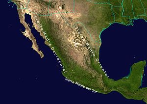
| 50. Unlikely.. Those mountains in the middle of Mexico will tear it apart |
| Printer Friendly | Permalink | | Top |
| alfredo
|
Sun Aug-19-07 10:06 PM Response to Reply #50 |
| 51. I forgot about the mountains. This could be a very deadly |
| Printer Friendly | Permalink | | Top |
| SoCalDem
|
Sun Aug-19-07 10:24 PM Response to Reply #51 |
| 53. Warm moist air hits cold mountain air and ..rain rain rain |
| Printer Friendly | Permalink | | Top |
| alfredo
|
Mon Aug-20-07 10:23 AM Response to Reply #53 |
| 57. It seems to be going to head south over the narrow part |
| Printer Friendly | Permalink | | Top |
| Aviation Pro
|
Sun Aug-19-07 08:08 PM Response to Original message |
| 36. There is not a hint of dry air between Dean and Mexico.... |
| Printer Friendly | Permalink | | Top |
| misanthrope
|
Sun Aug-19-07 08:23 PM Response to Original message |
| 42. Hurricane Gilbert (1988)... |
| Printer Friendly | Permalink | | Top |
| Warpy
|
Sun Aug-19-07 09:16 PM Response to Original message |
| 49. The storm is passing to the south of the island |
| Printer Friendly | Permalink | | Top |
| WritersBlock
|
Mon Aug-20-07 12:26 AM Response to Original message |
| 55. Interesting. |
| Printer Friendly | Permalink | | Top |
| Canuckistanian
|
Mon Aug-20-07 12:36 AM Response to Original message |
| 56. Anybody seen the animated NOAA site? |
| Printer Friendly | Permalink | | Top |
| DU
AdBot (1000+ posts) |
Wed May 08th 2024, 04:06 PM Response to Original message |
| Advertisements [?] |
| Top |
| Home » Discuss » Archives » General Discussion (1/22-2007 thru 12/14/2010) |
|
Powered by DCForum+ Version 1.1 Copyright 1997-2002 DCScripts.com
Software has been extensively modified by the DU administrators
Important Notices: By participating on this discussion board, visitors agree to abide by the rules outlined on our Rules page. Messages posted on the Democratic Underground Discussion Forums are the opinions of the individuals who post them, and do not necessarily represent the opinions of Democratic Underground, LLC.
Home | Discussion Forums | Journals | Store | Donate
About DU | Contact Us | Privacy Policy
Got a message for Democratic Underground? Click here to send us a message.
© 2001 - 2011 Democratic Underground, LLC