Welcome to DU!
The truly grassroots left-of-center political community where regular people, not algorithms, drive the discussions and set the standards.
Join the community:
Create a free account
Support DU (and get rid of ads!):
Become a Star Member
Latest Breaking News
General Discussion
The DU Lounge
All Forums
Issue Forums
Culture Forums
Alliance Forums
Region Forums
Support Forums
Help & Search
General Discussion
Related: Editorials & Other Articles, Issue Forums, Alliance Forums, Region ForumsAmazing how much this 1932 map looks like today's political map.
Guess the people who liked to control what others did then, still like the feeling.
[IMG]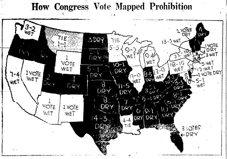 [/IMG]
InfoView thread info, including edit history
TrashPut this thread in your Trash Can (My DU » Trash Can)
BookmarkAdd this thread to your Bookmarks (My DU » Bookmarks)
4 replies, 1044 views
ShareGet links to this post and/or share on social media
AlertAlert this post for a rule violation
PowersThere are no powers you can use on this post
EditCannot edit other people's posts
ReplyReply to this post
EditCannot edit other people's posts
Rec (1)
ReplyReply to this post
4 replies
 = new reply since forum marked as read
Highlight:
NoneDon't highlight anything
5 newestHighlight 5 most recent replies
= new reply since forum marked as read
Highlight:
NoneDon't highlight anything
5 newestHighlight 5 most recent replies
= new reply since forum marked as read
Highlight:
NoneDon't highlight anything
5 newestHighlight 5 most recent replies
Amazing how much this 1932 map looks like today's political map. (Original Post)
shraby
Nov 2012
OP

tridim
(45,358 posts)1. One or two of those states will go "dank" by the end of the day.

ladjf
(17,320 posts)2. Somewhere on DU about three weeks ago, someone posted a map of the slave states
from 1860 and compared it to the blue and red states of today. Those maps also were almost identical. Maybe someone can find it an post it here.
ladjf
(17,320 posts)4. Here is the 1860 map showing slave states, states open to slavery and free states.
http://www.learner.org/biographyofamerica/prog10/maps/
Free States and Slave States, before the Civil War
Free States and Slave States, before the Civil War

Care Acutely
(1,370 posts)3. Hell. Isn't a big chunk of TX still dry?