General Discussion
Related: Editorials & Other Articles, Issue Forums, Alliance Forums, Region ForumsTracking Matthew folks - what if he does not turn North
and continues WNW - what then?
He is still going West (add)
 = new reply since forum marked as read
Highlight:
NoneDon't highlight anything
5 newestHighlight 5 most recent replies
= new reply since forum marked as read
Highlight:
NoneDon't highlight anything
5 newestHighlight 5 most recent replies

Iliyah
(25,111 posts)Nice to see you posting!

malaise
(269,157 posts)Shutters will go up later today. The impact will begin sometime late tomorrow - we're hoping for the eye to miss us but are as ready as we can be for whatever comes our way.

redstatebluegirl
(12,265 posts)Most likely late tonight or early tomorrow.
But the when and how sharp of a north turn is going to make all of the difference.

Gman
(24,780 posts)Put the path east of you. Models have been trending east.
B2G
(9,766 posts)It runs again in 20 minutes...should be interesting.
It's wild how far apart the GFS and Euro were last night.
malaise
(269,157 posts)Ah well.
Gman
(24,780 posts)And they haven't yet recovered from the earthquake.
malaise
(269,157 posts)Matthew is expected to produce total rain accumulations of 15 to 25
inches over southern Haiti, with possible isolated maximum amounts
of 40 inches. Matthew is expected to produce total rain
accumulations of 10 to 20 inches over eastern Jamaica, the Dominican
Republic, and eastern Cuba, with possible isolated maximum amounts
of 25 inches. This rainfall will likely produce life-threatening
flash floods and mud slides

MineralMan
(146,329 posts)malaise
(269,157 posts)

dixiegrrrrl
(60,010 posts)
and we know the damn things can be very unpredictable.
They poor folks in Louisiana must be going thru PTSD even this early.
malaise
(269,157 posts)Anyway they say it's coming between Haiti and Jamaica
B2G
(9,766 posts)Posting this in the even Malaise loses power so those who are so inclined can hear what's happening down there.
I've listened in the past...they have very good coverage.
http://www.jamaicaradio.net/power-106/
malaise
(269,157 posts)Here's another one
http://www.rjr94fm.com/live.php

csziggy
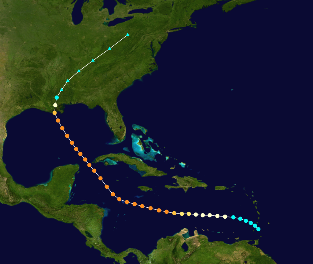
(34,137 posts)Then loop back to the east coming in between New Orleans and the Big Bend of North Florida:
![]() https://www.wunderground.com/hurricane/atlantic/2016/Hurricane-Matthew?map=historical
https://www.wunderground.com/hurricane/atlantic/2016/Hurricane-Matthew?map=historical
I'm keeping a close eye on Matthew. Tallahassee was already hit by one hurricane this year - Hermine came in the Thursday before Labor Day weekend and I was without power and water for five days. (Some friends lent me their generator when they got power back and let me use their shower but it was still an inconvenient situation.)
Historically the chances of two hurricanes hitting here are low but since the climate is changing past events are not a reliable indication of what might happen.
malaise
(269,157 posts)Time to hit the road
csziggy
(34,137 posts)I hope everyone in the path of Mathew will be safe! Matthew looks to be a nasty storm.
Baclava
(12,047 posts)"The Government will do what it can; it will do its part, but I have to appeal to the individual responsibility of each and every Jamaican to look out for your own safety and security ...Heed the warnings that are given from the Government, particularly warnings to evacuate” he urged.
http://www.jamaicaobserver.com/news/High-alertMet-Service-says-Jamaica-in-Hurricane-Matthew---s-cross-hairs_75725
do what you have to do to stay safe - good luck

Ms. Toad
(34,087 posts)I'll be there Thursday, unless Matthew doesn't turn . . .
csziggy
(34,137 posts)
Wilma wasn't as strong as far east as Matthew is and it turned back east earlier than many storms that take the south of Cuba track. For more: https://en.wikipedia.org/wiki/Hurricane_Wilma
Ms. Toad
(34,087 posts)There are three in the map in post 12 that start where Matthew started; one of those three went through the gulf, then up across the US. That's the one I'm asking about.
Wilma swung back out into the ocean, rather than up across the US. Katrina took a similar path across the us, but hit Florida on the way in, rather than starting down near South America.
(My first trip to Cozumel was shortly after Wilma.)
csziggy
(34,137 posts)"Tracks of all October Category 3 and 4 Hurricanes within 2 degrees of Matthew between 1851 and 2015." Weatherunderground does not name the particular storms that created the tracks.
Ms. Toad
(34,087 posts)I read it as there being only 3 (or perhaps only 2) October Category 3 and 5 Hurricanes in that time period, within 2 degrees of Matthew, shown by the three (2?) tracks (rather than being a composite).
Why would they choose to create three composite tracks for a larger number of hurricanes? I can't see that would be much use to anyone.
Ms. Toad
(34,087 posts)Hazel (the track that goes East of Florida)

and an unnamed hurricane in 1915 that passed betwee Mexico and Cuba and hit Louisiana.
csziggy
(34,137 posts)Ms. Toad
(34,087 posts)So once I had one of the two, I knew the other made landfall in Louisiana in October. It didn't take too long after that, since there weren't that many.
I guess seeing the two paths makes me feel a bit better. Without minimizing the destruction Matthew is likely to leave in its wake - my last year has been a personal hell (three chronic/major illnesses, including cancer). I desperately need the diving break I have planned for Cozumel this week.
csziggy
(34,137 posts)So I hope you have a good vacation in Cozumel.
Ms. Toad
(34,087 posts)The dive resort we're staying at called us yesterday to reassure us that (1) Matthew isn't headed their way and (2) we should come even if it does . . .
OnlinePoker
(5,725 posts)Looks like it's close to making the turn north. Good thing is, hurricane force winds only extend out 30 miles so major damage will be concentrated in a narrow band. Not great if you're in that band, though.
malaise
(269,157 posts) 
kentuck
(111,110 posts)It looks very bad.
malaise
(269,157 posts)last minute
malaise
(269,157 posts)this mess
kentuck
(111,110 posts)Stay in the hole.
malaise
(269,157 posts)It's way bigger than Gilbert but Gilbert steamed through from Morant Point to Negril crushing everything in the way. It will b very bad for lots of people on our island.
One of my siblings suggested that we head for Miami for a week and I askedd her of she wanted us to greet Matthew in Florida - we is so afraid and they survived Andrew. 

chillfactor
(7,584 posts)
greytdemocrat
(3,299 posts)For now. Looks like it will miss you
which is a good thing. Still lots of rain
I bet.
greytdemocrat
(3,299 posts)It's on the move, NNW at 6 mph
Baclava
(12,047 posts)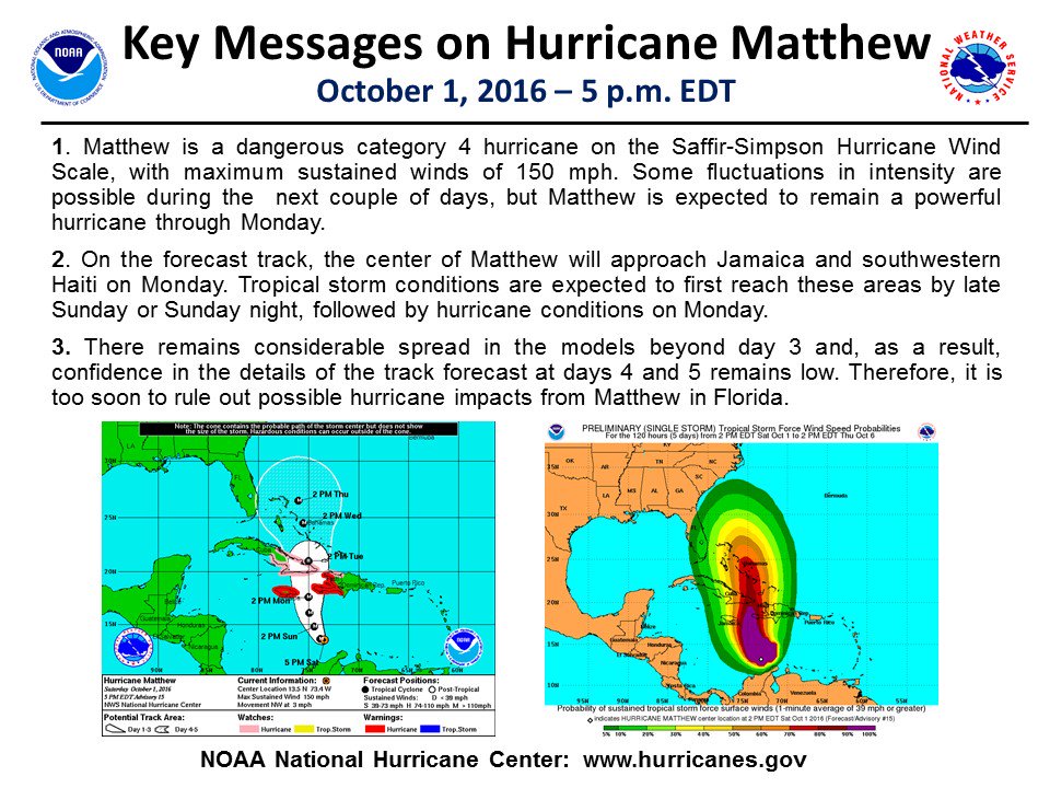
malaise
(269,157 posts)Damn
Look at this monster - I've never seen anything like this

B2G
(9,766 posts)That is not good news.
Baclava
(12,047 posts)when they get this big they take on a life of their own

suffragette
(12,232 posts)
malaise
(269,157 posts)but it looks unusual. We've prepared and aren't taking any chances. We're not leaving here until Matthew is finished doing his thing.
suffragette
(12,232 posts)https://www.wunderground.com/blog/JeffMasters/matthew-stalls-and-weakens-but-expected-to-head-north-threat-to-us
All factors considered, a Category 3 hurricane at landfall Monday night is probably the most likely scenario. It is unknown what role, it any, the unusual blob of heavy thunderstorms that has persisted on Matthew’s east side might play in the future evolution of the storm. If this intense area of thunderstorms remains intact through Monday night, it could result in catastrophic rains for Haiti.
I guess odd blobs are the new normal. We have the hot water Pacific blob over here which seemed to go away, but was just hiding in the ocean depths before re-emerging. Now you have extra thunderstorm blobs joining with a hurricane.
Good thoughts to you!

malaise
(269,157 posts)Time for some fresh coconut water and nuts. It's going to be a rough ride if this i sthe beginning - serious lightning - heavy rain.
suffragette
(12,232 posts)I know it's just thoughts reaching out through electrons, but we are all here for you.
malaise
(269,157 posts)for the next few days. There is no wind with the outer bands where we are in St Andrew.
suffragette
(12,232 posts)
malaise
(269,157 posts)That's a recipe for mud slides.
Masters says threat to the US has increased
Matthew Stalls and Weakens, but Expected to Head North; Threat to U.S. Increases
<snip>
https://www.wunderground.com/blog/JeffMasters/comment.html?entrynum=3457
Longer-range track forecast for Matthew: risk increases to U.S. East Coast
Over the past two days, our two best computer models have been trending towards a more westerly track for Matthew late this week, increasing the odds that Matthew will make a direct hit somewhere along the U.S. East Coast. Sunday’s 00Z European model and 06Z GFS model had Matthew coming very close to or making landfall in North Carolina 6 - 7 days from now. As one can see from the latest set of ensemble model runs (Figure 4), just about any location along the East Coast could potentially see a hurricane landfall this week. Since the hurricane is expected to be moving roughly parallel to the coast, a long stretch of the coast may receive strong winds and heavy rain from Matthew. We do have three decent models predicting a path for Matthew well away for the U.S. coast late in the week, though—the HWRF, Canadian and GFDL—so it is not yet a foregone conclusion that Matthew will impact the U.S. coast.
suffragette
(12,232 posts)And not good that it is moving so slowly.
Better that bad boy should scoot on through quickly.

BumRushDaShow
(129,449 posts) malaise
(269,157 posts) B2G
(9,766 posts)suffragette
(12,232 posts)B2G
(9,766 posts)greytdemocrat
(3,299 posts)At times has been bigger than the
hurricane. I've never seen anything
like it before.
avebury
(10,952 posts)remains safe.
mia
(8,362 posts)Following your thread and another one on Storm2k:
http://www.storm2k.org/phpbb2/viewforum.php?f=59
malaise
(269,157 posts)and the good thoughts. It's stopped raining for now

Jeanette in FL
(3,356 posts)Been thinking of you all weekend while watching this storm. Hope that it stays east of you. Stay safe my friend. What a storm Matthew is! Came on to DU and was glad to read your updates. Keep the coming and thanks for the radio/media links. Will be listening! Jeanette in FL
malaise
(269,157 posts)Looks like the most you'll get is a swipe on your East coast. We're as ready aswe'll ever be.
I see Ben Kennedy is all over Kingston
Jeanette in FL
(3,356 posts)We are back down in West Palm Beach, so we have been watching closely. Looks like it will stay east of us. Rain and wind, I hope. It has been over 11 years since we have had anything down here. Who is Ben Kennedy? LOL

titaniumsalute
(4,742 posts)greytdemocrat
(3,299 posts)The huge amount of rain being
recorded is amazing. One weather station
in the DR recorded 5.33 inches in 1 hour.
malaise
(269,157 posts)We expect 10-20 inches of rain which is a lot of rain over two and a half ways. Just steady rain now.
Baclava
(12,047 posts)Bad news for the Bahamas, 15 ft storm surge predicted
![]()
malaise
(269,157 posts)We'll see - we're just waiting for whatever and since Matthew is 195 miles SE of Kingston moving at 5mph, that's quite a wait. Guess more outer bands will move in later but there has been no heavy rain in my part of St Andrew today and no lightning and thunder since yesterday.
Baclava
(12,047 posts)
malaise
(269,157 posts)Rick Scott in full panic mode in Florida.
greytdemocrat
(3,299 posts)you guys should be fine except for flooding. The
Bahamas on the other hand...