Overnight evacuation for Okanogan area, Tonasket as fire rages
Source: KING 5 News and Associated Press
KING 5's Jake Whittenberg reports
7:22 a.m. PDT August 21, 2015
Okanogan Complex Fire
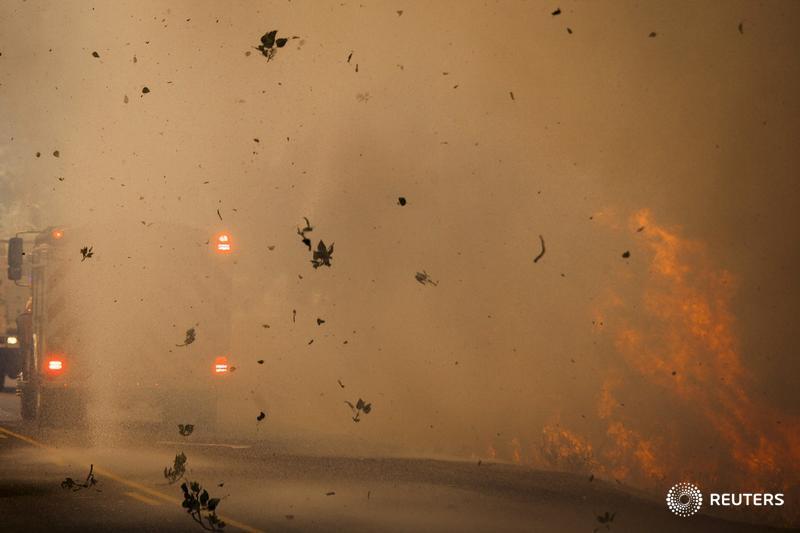
(Photo: KING 5 News)
42 CONNECT 25 TWEETLINKEDINCOMMENTEMAILMORE
OKANOGAN, Wash. - Emergency officials before dawn Friday called for the immediate evacuation of areas near the north-central Washington community of Okanogan as a wildfire raged.
The Okanogan County Emergency Management department sent out the orders around 2 a.m.
The department said orders were for parts of the northwest outskirts of town. The area was described as populated, but it wasn't immediately clear how many people were affected.
The agency was urging area residents to stay alert for messages about the fire.
Live social media wildfire updates from KING 5 and emergency management agencies
Read more: http://www.king5.com/story/news/local/wildfires/2015/08/21/evacuation-okanogan-area-tonasket-fire-rages/32103005/
 = new reply since forum marked as read
Highlight:
NoneDon't highlight anything
5 newestHighlight 5 most recent replies
= new reply since forum marked as read
Highlight:
NoneDon't highlight anything
5 newestHighlight 5 most recent replies

riversedge
(70,242 posts)Reuters Top News ?@Reuters 1m1 minute ago
Brave crews battle wildfires as Pacific Northwest braces for high winds forecast in the U.S.: http://reut.rs/1EHmOXq
riversedge
(70,242 posts)3 firefighters killed in wildfires near Twisp
KING5.com? - 23 hours ago
The Okanogan County Sheriff's Office says three firefighters have died and four ... as raging wildfires advance on the towns of Twisp and Winthrop in north-central Washington
Yallow
(1,926 posts)It's Just Gonna Get Worse
The area burned last year remember?
Deal With It
http://www.democraticunderground.com/112790160
Sign at mouth of Methow Valley
"Caution Entering Climate Change Impact Area"
Then nothing but burned trees for 20 miles.
Welcome to the new America.
Exxon!!! Big Coal!!! Yehawwww!!!!
riversedge
(70,242 posts)whow. but glad to see the sign. I have never seen-nor known of signs like that.
I drove thru W. Wash about 8 years ago in the summer. It was dry but had a beauty and quietness about it that I appreciated. Been to E. Wa many times but wanted to see W. Wa.
Keep safe.
ps. I am in WI--almost too much rain here this summer but drought about 5 years ago

dixiegrrrrl
(60,010 posts)Been in that area many times, visiting friends in E. Wash and going over the North Cascades Highway.
Breaks my heart to read about so much burning up.
Yallow
(1,926 posts)Now just blackened trees....
dixiegrrrrl
(60,010 posts)I at least can still see in my mind all the memory pictures.
Yallow
(1,926 posts)Drill Baby Drill!!!!

uppityperson
(115,677 posts)

Last reading at Omak was wind of 45, gusting to 58
http://www.wrh.noaa.gov/mesowest/getobext.php?wfo=otx&sid=KOMK&num=72&raw=0
This map is centered on Chelan, pull a bit east and north to see the Okanogan.
http://www.mappingsupport.com/p/gmap4.php?ll=47.867538,-120.020829&z=11&t=h,Wind_in_6_hrs,MODIS_thermal,Current_fire&q=http://www.propertylinemaps.com/p/public_land_map/USA/USA_wildland_fire.txt
chapdrum
(930 posts)They can't afford it? If that is so, perhaps The Owners might find it in their small but concerned hearts to find
some money to efficiently tackle these (and future) conflagrations. Perhaps a few ducats might be pared
from the NASA budget (but don't hold your breath).
uppityperson
(115,677 posts)dropping the red stuff.