Forgotten Mayan city 'discovered' in Central America by 15-year-old
Source: Independent
Forgotten Mayan city 'discovered' in Central America by 15-year-old
William Gadoury made a link between the location of Mayan cities and the civilization's major constellations
Samuel Osborne |
@SamuelOsborne93 |
13 minutes ago|
[font size=1]
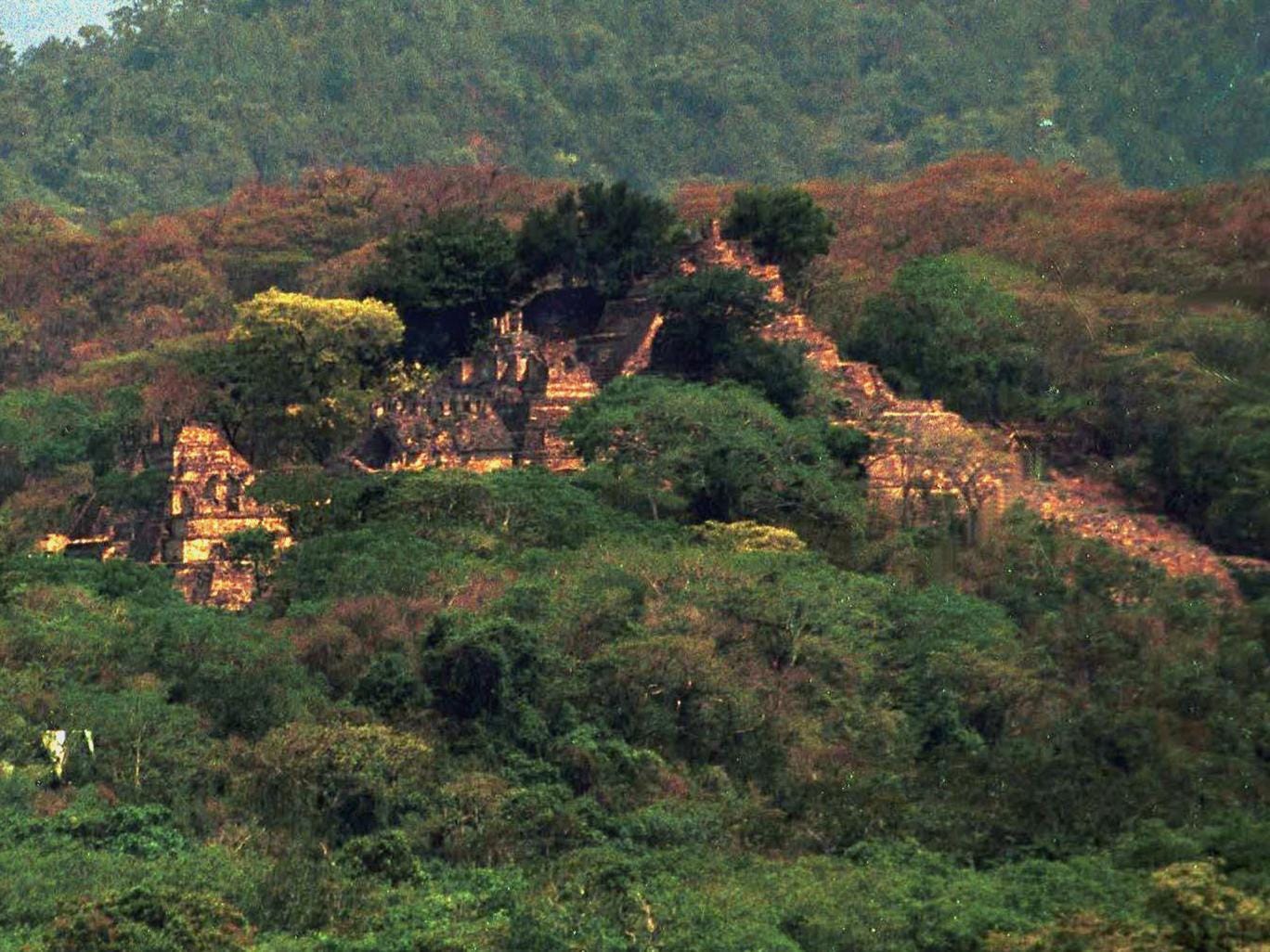
View of the ancient 'Valley of the Warriors' in Chiapas, Southern Mexico, which has recently been shown to be the largest pyramidal acropolis in Mesoamerica (file image) JANET SCHWARTZ/AFP/Getty Images
[/font]
A 15-year-old boy believes he has discovered a forgotten Mayan city using satellite photos and Mayan astronomy.
William Gadoury, from Quebec, came up with the theory that the Maya civilization chose the location of its towns and cities according to its star constellations.
He found Mayan cities lined up exactly with stars in the civilization's major constellations.
Studying the star map further, he discovered one city was missing from a constellation of three stars.
Read more: http://www.independent.co.uk/news/world/americas/forgotten-mayan-city-discovered-in-central-america-by-15-year-old-a7021291.html
 = new reply since forum marked as read
Highlight:
NoneDon't highlight anything
5 newestHighlight 5 most recent replies
= new reply since forum marked as read
Highlight:
NoneDon't highlight anything
5 newestHighlight 5 most recent replies

L. Coyote
(51,129 posts)Last edited Mon May 9, 2016, 09:53 PM - Edit history (1)
they bother to use the elevation data in Google earth to view what the topography is.
And that photo, it has nothing to do with the story except it is a ruin.
truebluegreen
(9,033 posts)L. Coyote
(51,129 posts)Last edited Tue May 10, 2016, 06:15 PM - Edit history (3)
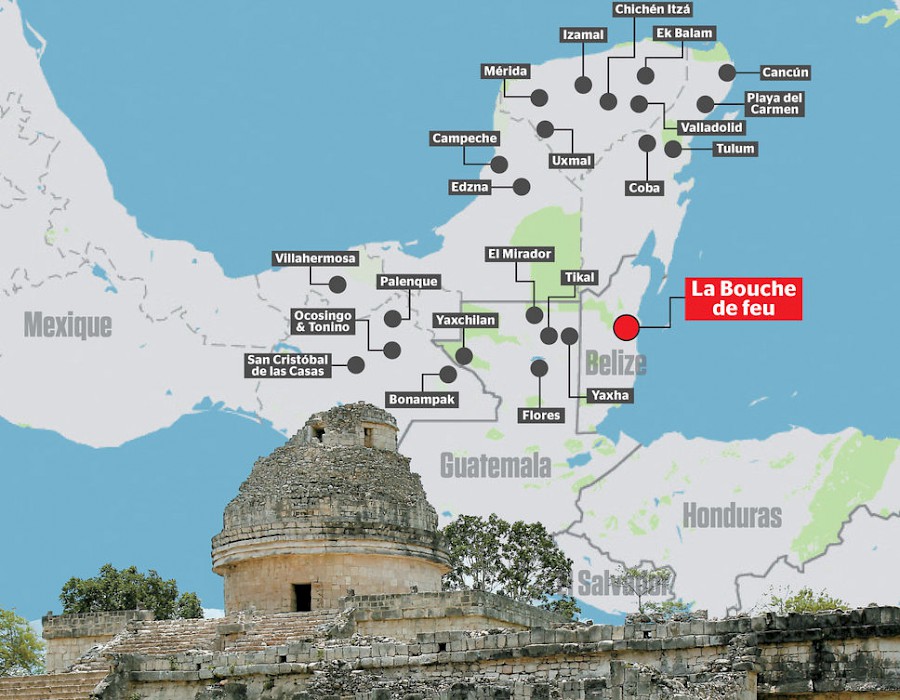
Check this out, a map of the location in Mexico. Ooooophs!!

csziggy
(34,137 posts)A fifteen year old from Quebec has used satellite photos, Mayan astronomy and his own intuition to solve some questions about the placement of Mayan cities and to discover a new city. William Gadoury loves everything Mayan and was studying Mayan constellations when he overlayed a constellation map on a map of the Yucatan Peninsula. He discovered that the known cities, like Chichen Itza and Uxmal, were exactly lined up with the stars in major Mayan constellations. Using this same map and thought process, he noticed that the third star in the 23rd constellation he was studying was missing. He found satellite images from space agencies, including NASA, JAXA (from Japan) and Google Earth, and discovered a third city where the third star of the constellation said it would be. He has named this city, as yet unexplored on the ground, K'aak Chi, or Mouth of Fire. The lost city has a pyramid that is 86 meters high, as well as 30 other visible (from the photos) structures. It is on the border with Belize. This young man is hoping to go to the International Science Fair in Brazil in 2017 but is lacking in the necessary funds. If you are interested in helping him get there, you can contact him at will_maya@live.ca. Felicidades, William!
http://www.yucatanliving.com/news/yucatan-news-26
Maybe you could contact him for more information.

Judi Lynn
(160,598 posts)L. Coyote
(51,129 posts)Here is another one, pointing to the Mexican site, again in Belize!

Someone finally corrected the first one, made it point to the corn field, but I'm not finding the corrected version now.
sulphurdunn
(6,891 posts)Maybe they did and it was omitted from the article. Anything that rises suddenly from the jungle floor, even if it covers only a few meters and is only a few stories high, can be a ruin. Archeologists I once spoke with in Tikal thought it very likely that undiscovered cities exist in the Yucatan's interior. Who knows?

hibbing
(10,107 posts)I love when stuff like this is discovered in this day and age. Thanks for posting!
Peace

tomm2thumbs
(13,297 posts)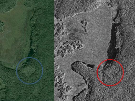
interesting as it also appears another structure, below/right of the one circled
I had done some research with a man who helped discover long-lost native American roads/paths by flying over land in the late of the evening, to see at extreme lighting angles, the differences in growth patterns of plants -- often native travelers would accidentally drop seeds from their carts as they traveled, and they can locate paths by differences in plant-types along paths, as well as heights of existing overgrowth compared to worn areas from travel. Fascinating and glad a lot of folks have their interests on such keen thinking about our history.
L. Coyote
(51,129 posts)Last edited Mon May 9, 2016, 09:52 PM - Edit history (1)
Native American surveys planted specific plants to mark their surveys per written ethnology sources.
See ancient earthwork remains in Google earth here:
Hundreds of Geoglyphs Discovered in the Amazon
tomm2thumbs
(13,297 posts)repost if you have a sec - would love to see them - thanks
L. Coyote
(51,129 posts)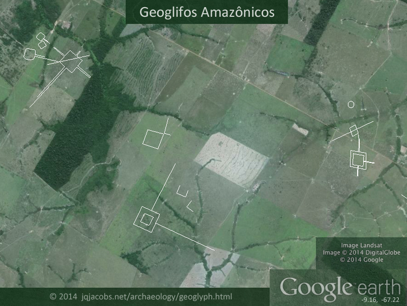
lunamagica
(9,967 posts)L. Coyote
(51,129 posts)Central America begins at the Isthmus, not at the Mexican border. The political division is another matter, but that's an arbitrary division.
tomm2thumbs
(13,297 posts)The genius of William, however, was to analyze a 23rd constellation. It contained three stars and only two cities matched on the card. According to his theory, so it should be a 118th Mayan city in a remote and inaccessible location in the Yucatan Peninsula, Mexico. Analyses from satellites in different space agencies have revealed that there was indeed a pyramid and thirty buildings at the precise location identified by the young man.
The Journal had access to satellite images which we see different structures of what may be an ancient city. "Geometric shapes, such as squares or rectangles, appeared on these images, forms that can hardly be attributed to natural phenomena," says remote sensing specialist at the University of New Brunswick, Dr. Armand LaRocque.
Not only he would have discovered a new Mayan city, but it would be one of the five largest.
Judi Lynn
(160,598 posts)I'd love to hear he's going to get to go there in person!
Judi Lynn
(160,598 posts)How This Canadian Teen Discovered A Lost Mayan City
by Charles Carrot | 15 hours ago
At just 15 years old, Quebec-native William Gadoury is already known to the Canadian Space Agency, the Japan Aerospace Exploration Agency and even NASA. Because, despite his young age, the teen’s research has allowed him to make quite an extraordinary discovery.
Making a link between constellations and Mayan cities, William put forward a hypothesis that would locate an ancient civilisation site previously unknown to scientists, reports Journal de Montréal. The theory was then confirmed by satellite analyses from the aforementioned space agencies.
Fascinated by the topic for years, William analysed 22 constellations known by the Maya and discovered that 117 of their cities were built according to the position of the stars – a correlation that had never been realised up to that point.
He then analysed a 23rd constellation containing three stars but discovered only two corresponding cities. The teen then deducted that a 118th city must therefore exist and set about presenting his calculations to the Canadian Space Agency in November 2014.
More:
http://www.konbini.com/en/inspiration/mayan-city-discovered/
[center]

 [/center]
L. Coyote
(51,129 posts)At least now we have some information and decent writing. Not to mention, the photos are related to the facts, not just pulled out of a hat.

a la izquierda
(11,797 posts)There's no evidence yet that there's anything there.
And the kid was presumptuous enough to name the city? Hmm. How about consulting with, oh you know, actual Mayas in the area.
L. Coyote
(51,129 posts)I agree, this is very doubtful work and until we see the data and methods, I'm guessing there isn't much here even if he found a Maya ruin. Given the number of combinations possible and the density of settlement there, how could he not find a ruin.

SunSeeker
(51,658 posts)That old Mentos and soda volcano just won't cut it.

MissB
(15,812 posts)I was thinking the same thing!
L. Coyote
(51,129 posts)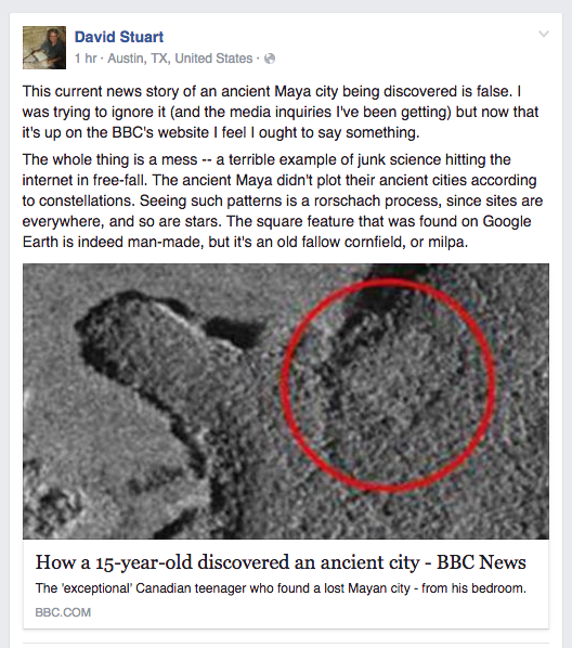
So, who came up with the corn field photo, and does it have anything to do with the story? Damn web, 90% of our time is not spent calling bullshit!

MisterP
(23,730 posts)Judi Lynn
(160,598 posts)A 15-year-old just discovered a lost Maya city in the Mexican jungle
What did you do when you were 15?
BEC CREW
10 MAY 2016
William Gadoury, a 15-year-old school student from Quebec, Canada, has found something that’s been hidden from archaeologists for centuries - a lost city of the Maya civilisation, buried deep in the Yucatan jungle of southeastern Mexico.
He didn’t do it by hiring a bunch of expensive equipment, hopping on a plane, and slaving away on an excavation site - he discovered the incredible ruins from the comfort of his own home, by figuring out that the ancient cities were built in alignment with the stars above.
"I did not understand why the Maya built their cities away from rivers, on marginal lands and in the mountains," Gadoury told French-Canadian magazine, Journal de Montréal. "They had to have another reason, and as they worshiped the stars, the idea came to me to verify my hypothesis. I was really surprised and excited when I realised that the most brilliant stars of the constellations matched the largest Maya cities."
Gadoury had been studying 22 Maya constellations for years before releasing that he could line up the positions of 117 Maya cities on the ground with maps of stars and constellations above - something that no one had pieced together before.
More:
http://www.sciencealert.com/a-15-year-old-just-discovered-a-lost-maya-city-in-central-america
L. Coyote
(51,129 posts)What were you doing?
Judi Lynn
(160,598 posts)L. Coyote
(51,129 posts)And you heard it first on DU in this thread, a full day before the Web figured out a corn field is sometimes just a corn field.....

HOW CAN YOU resist a headline like “Quebec teen may have discovered long lost Mayan city”? Alas, the story going viral today is too good to be true, according to archaeological experts. The supposed lost pyramid? More likely an abandoned field.
This much is true: William Gadoury, now 15, won a contest to present his theory that Maya cities were correlated with constellations at a conference a few years ago. He happened to be next to a booth of the Canadian Space Agency, where scientists took notice and decided to help the kid out. So Canada turned its RADARSAT-2, a satellite that usually tracks sea ice and shipping in Canada, to a remote corner of Mexico—right where Goudry’s constellation theory predicted a city would be. Lo and behold, those images seemed to show manmade structures.
Satellite imagery can be a powerful tool for studying the ancient world. “Space archaeologists” like Sarah Parcak want to use readily available data like this to lower the barriers to entry in science, and a teenager finding a long-lost city would be a pretty stunning proof of concept. But that isn’t what the images show.
The square in the CSA’s satellite images is probably an abandoned field, and another spot may be a small dry lake or clearing in the jungle, says archaeologist Ivan Šprajc. Gizmodo, in its updated story, has noted the same about the square structure.
............
Now we are stuck with calling bullshit on this story for the next decade!
Judi Lynn
(160,598 posts)Clearly knew what you were saying, too.
It took someone really familiar with the terrain, with how to read information to spot it.
L. Coyote
(51,129 posts)Oh the irony, kid wins science fair calling marijuana field a lost city ..... 
Judi Lynn
(160,598 posts)They'll have to smoke what they find.
L. Coyote
(51,129 posts)Judi Lynn
(160,598 posts)
dembotoz
(16,825 posts)its a love hate thing when i read articles about kids who are obviously smarter and more accomplished than i shall ever be....

Hekate
(90,773 posts)

appalachiablue
(41,168 posts)
NWCorona
(8,541 posts)Prism
(5,815 posts)From an informative Reddit post:
In the case of this article, the purported new city is in eastern/central Belize not far from the coast. There is absolutely no way that a huge city is located there that nobody has ever seen before. It may not be registered in a database that the student in question had access to, or it may not be as large as he thinks it is. The article itself is rather inconsistent on the size of the site. It claims at one point that the site comprises 30 visible architectural mounds (which makes it fairly small to medium size by Mesoamerican standards), and at another point claims it covers 80 to 120 square km (which would make it probably the biggest in the Western Hemisphere). The article also claims that it is the fourth largest in the Maya world (I'm assuming after Tikal, Calakmul, and Caracol).
There's a joke among Mesoamerican archaeologists. What's the typical nuclear family in Belize? The mother, the father, the children, and the Maya archaeologist staying with them to study the nearby ruins. Of all the regions in Mesoamerica, Belize (especially eastern Belize) is the most heavily studied. This is due to the fact that Belize's official language is English, they're the only country in the area that allows field schools, and the Classic Maya have the sexy alure of the "lost city in the jungle" trope that dominates pop archaeology. The odds that a city that big, in that particular area, had escaped study for that long are slim to none.
The second claim of the article is that this somehow verifies the theory that the Maya landscape is a massive cosmogram where the placement of cities reflects the stars in Maya constellations. Lets think about that for a minute. How are you overlaying constellations on the landscape? How are you defining the orientation of the constellations? How are you measuring distance? The fact is that the Maya lowlands was so densely populated that if you were to take a series of random points and scale and rotate them enough you could probably get it to line up with a pattern of archaeological sites. Hell, you could probably throw a dart at a map of the Peten and you'd probably hit pretty close to an archaeological site.
But on a deeper level, the idea that city placement corresponds to cosmology on that scale implies a top down plan that we frankly know didn't exist. Maya cities have different origins. Some were occupied going back to the Formative/Preclassic period. Others were founded later. All were ruled by their own political dynasties that did not typically coordinate with each other. The entire Classic Maya civilization was dominated by an elite culture composed of feuding lineages that were constantly seeking to one-up their rivals through warfare and competitive festivals. So while we have lots of evidence for cosmically-informed planning within cities, there are few examples of that between cities. To suggest that such a cosmic order existed across the entire Maya lowlands would require rejecting mountains of evidence demonstrating the opposite.
What the kid is doing is very cool, and he has a bright future ahead of him. But, as is usual, the media blew the story right up without doing even the slightest bit of due diligence.
immoderate
(20,885 posts)The star map thing does not make sense. 
--imm
L. Coyote
(51,129 posts)Last edited Tue May 10, 2016, 09:24 PM - Edit history (1)
I know that location, near a ruin I'm interested in, Uxul: 17.9451, -90.1669

Looks like an abandoned corn field. Probably another stupid journalist just grabbing the first rectangle they could find, and completely unrelated to the young man's work again.
yellowcanine
(35,701 posts) L. Coyote
(51,129 posts)more than likely that's been abandoned. But, corn is what they grow for subsistence.
Ferd Berfel
(3,687 posts)

and of course

a la izquierda
(11,797 posts)It's absolutely nothing new that the Maya used the stars to map their cities. This theory has been around for a really long time.
L. Coyote
(51,129 posts)Last edited Tue May 10, 2016, 09:45 PM - Edit history (2)
We corresponded back in the 1980s, about the Palenque light tubes.
He claims the Maya aligned some constructs and site orientations according to the cosmos.
Aveni, Anthony F. 1981. Archaeoastronomy in the Maya Region: A Review of the Past Decade. Archaeoastronomy, 3, pp. S2-S16
Aveni, Anthony F. 1979. Venus and the Maya. American Scientist, 67:274-285.
Aveni, Anthony F. and Horst Hartung. 1991. Archaeoastronomy and the Puuc sites. Arqueoastronomía y Etnoastronomía en Mesoamérica. J. Broda, S. Iwaniszewski, and L. Maupomé, eds., (Inst. de Investig. Hist., Serie de Hist. de la Ciencia y la Technología, 4). México, U. N. A. M. pp. 65-95.
Aveni, Anthony F. and Horst Hartung. 1989. Uaxactun, Guatemala, Group E, and similar assemblages: an archaeoastronomical reconsideration. In World Archaeoastronomy, edited by A. Aveni, pp. 441-461. Cambridge University Press, Cambridge.
L. Coyote
(51,129 posts)May 11, 2016
The apparent discovery of a previously unknown Mayan city in the Yucatan jungle by a 15-year-old Canadian boy has been dismissed as "junk science" by a US archaeologist who was also a child prodigy at the same age on the same subject.
Others think the new "city" may be a cornfield. ...........

Great article, especially the last part about David's youth. He grew up in the Maya ruins working with his Dad, Dr. George Stuart, a National Geographic archaeologist. I sent George some of my first Maya site relationship study notes back then.
L. Coyote
(51,129 posts).... La méthode exposée par William consiste, premièrement, à localiser et à identifier les cités majeures possédant de grandes pyramides sur le territoire maya. Pour les trouver, il utilise le site Web de Wikipédia et il imprime la liste des plus importantes cités mayas. Ce site lui permet de connaître les coordonnées géographiques de certaines grandes cités.
Ensuite, sur le site Web de Google Earth, il inscrit dans l’outil de recherche chacune des cités. Puis, William crée un repère pour celles qu'il trouve. Grâce au site Web Mayagis, il compare la liste et l’emplacement des cités qu'il a déjà trouvées et ajoute les cités manquantes. Les données du site Mayagis se fusionnent directement sur le site Google Earth et elles lui précisent l’endroit et l’importance des cités.
Deuxièmement, William cherche les étoiles que les mayas pouvaient voir de leur territoire soit entre les latitudes 13oN et 22oN. À partir du site Web Cosmovisions, il décalque sur des feuilles transparentes des constellations en commençant par les constellations circumpolaires de l’hémisphère nord. Il identifie les constellations et il trouve l’étoile la plus brillante ayant la plus forte magnitude apparente pour chaque constellation, Alpha étant généralement la plus brillante.
Troisièmement, à l’aide des feuilles transparentes et d’un rapporteur d’angle, il compare la forme et les angles des constellations avec la disposition géographique des cités mayas qu'il a déjà inscrites sur le site Web Google Earth.
Sa méthode lui permet, de découvrir en avril 2013, une première représentation de constellation: le W de Cassiopée. .............
Judi Lynn
(160,598 posts)Teen's Discovery of 'Lost' Maya City is a Very Western Mistake
Why modern astronomical maps may not lead us to ancient sites.

A Canadian teenager used the position of a constellation to identify the location of a possible Maya city where an anomaly, shown above on Google Earth (left) and as a satellite image (right) was identified. Scholars argue whether it represents Maya construction or simply an abandoned corn field.
Satellite image courtesy of Canadian Space Agency
Kristin Romey
PUBLISHED May 11, 2016
For gee-whiz value, the announcement has been hard to beat: A Canadian teenager discovers a lost Maya city without even stepping foot in the Central American jungle.
Unfortunately, this "discovery" appears to be the well-intentioned, albeit faulty, result of modern Western education colliding with an ancient civilization that saw the world in a very different way.
According to the original news report, 15-year-old William Gadoury correlated more than 20 Maya constellations against a map of known Maya cities. The cities lined up perfectly with the star map, with the exception of a "missing" settlement in a constellation that includes the sites of Calakmul and El Mirador.
Gadoury pinpointed the location of the potential site in Campeche, Mexico by using its corresponding star. An analysis of satellite imagery from the location, performed by Armand LaRocque, an honorary research associate at the University of New Brunswick, allegedly revealed a pyramid and dozens of buildings.
More:
http://news.nationalgeographic.com/2016/05/20160511-Maya-Lost-City-Canadian-Teen-Discover-Constellations-Archaeology-Satellite-Stars-Gadoury/
DU'er L. Coyote nailed it here in no time at all.
tabasco
(22,974 posts)"Discovered ancient city at age 5."