Tropical Storm Florence's threat to Carolinas increases as it nears hurricane status
Source: myrtlebeachonline.com
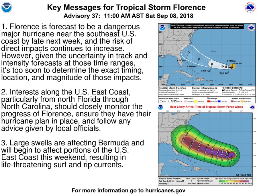
The chances of a direct hit from Tropical Storm Florence along the Carolinas increased Saturday, according to a release from the National Weather Service in Wilmington, North Carolina.
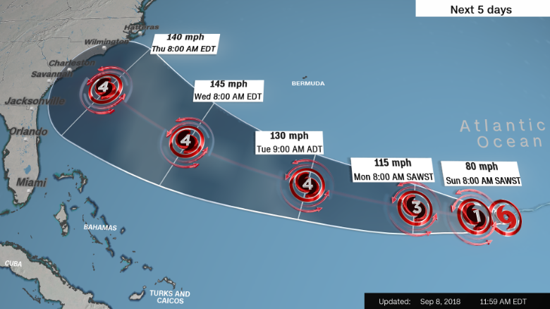
Florence remains a tropical storm but is forecast to become a hurricane Saturday night as it continues on a westerly track toward the East Coast of the United States, the NWS reports. As of 10:30 a.m. Saturday, the storm was 840 miles southeast of Bermuda while heading west at 9 mph with maximum winds of 65 mph.
The storm is projected to take a west-northwest track Tuesday into Thursday, possibly as a major hurricane, the NWS says.
 :large
Read more: https://www.myrtlebeachonline.com/news/local/article218057775.html
Heads up East Coast!
 = new reply since forum marked as read
Highlight:
NoneDon't highlight anything
5 newestHighlight 5 most recent replies
= new reply since forum marked as read
Highlight:
NoneDon't highlight anything
5 newestHighlight 5 most recent replies

gristy
(10,667 posts)Maximum sustained winds remain near 65 mph (100 km/h) with higher
gusts, but Florence is likely to restrengthen to a hurricane by
tonight. Rapid intensification is expected to start on Sunday, and
Florence is forecast to be a major hurricane by Tuesday.

Scurrilous
(38,687 posts)
Throckmorton
(3,579 posts)We are beginning storm preps today, and my wife is taking my elderly parents and their cat to my brothers in Northern Virginia on Monday.
3 Cats, 2 dogs, Henry the Giraffe, and I are all leaving Wednesday at daybreak.
We made hotel reservations in Fairfax VA for Monday Night to god knows when.
Scurrilous
(38,687 posts)Those things are lining up in the Atlantic and it doesn't look good for your area.

ooky
(8,929 posts)in the present potential projected path of the storm. Of course, living in ENC this won't be my first rodeo. Seems like we get to do this every couple of years or so here.
Usually these powerful storms slow down pretty quickly to cat 1 or borderline cat 2 as they approach the coast and no stronger when they roll over us. I've had trees down, fences blown over, shingle damage, all common problems. Swimming pool filled up with crap if I don't cover it, this time I will. We always ride them out, sitting inside with no electricity and feeling our house shake from ~100 mph wind gusts. But if it looks stronger than borderline cat 2 we will head west for my sister's house in SW Va. From my experience I would never consider sitting through a cat. 3 or 4.
Baclava
(12,047 posts) ?width=540&height=405&fit=bounds&auto=webp
ooky
(8,929 posts)Tonight's track has it coming on shore on top of us @ cat 3 on Thursday If that holds until Wednesday morning we're out of here.
Baclava
(12,047 posts)Hurricane Florence is a Category 4 storm, on track to hit Southeast coast by Friday morning
Hurricane Florence is a rapidly strengthening major storm with sustained 130 mph winds as it heads toward a potentially devastating landfall in the Southeast U.S. later this week, already prompting evacuation orders on the North Carolina coast.
The National Hurricane Center is warning of “life-threatening” storm surge in the Carolinas and Virginia, as well as “a prolonged and exceptionally heavy rainfall event” in the Southeast and mid-Atlantic.
“All interests from South Carolina into the mid-Atlantic region should ensure they have their hurricane plan in place and follow any advice given by local officials,” hurricane center forecasters wrote Monday morning.
http://www.baltimoresun.com/news/weather/weather-blog/bs-fe-tropical-storm-florence-update-20180908-story.html
Baclava
(12,047 posts)Evacuation ordered for SC coast ahead of Hurricane Florence
S.C. Gov. Henry McMaster announced a mandatory evacuation of the South Carolina coast on Monday. All eight counties along the coast would begin evacuating as of noon on Tuesday, McMaster said at a press briefing on Monday.
McMaster said he would reverse lanes on four main roads to facilitate the evacuation. As of noon Tuesday, lanes will reverse on Interstate 26 from Charleston to Columbia and Highway 50 from Myrtle Beach. Highways 278 and 21 in Beaufort County will be ready for reversal as of noon, but officials will wait to make an order at that time.
https://www.myrtlebeachonline.com/news/state/south-carolina/article218123955.html


BumRushDaShow
(129,482 posts)Link to tweet
TEXT
Margaret Orr
✔
@MargaretOrr
So we have TS Florence, TS Helene, Depression # 9 & 20% chance tropical development for trough of low pressure west of Bermuda. Right on cue! @wdsu #tropics
12:01 AM - Sep 8, 2018 · New Orleans, LA

Link to tweet
TEXT
Hurricane Tracker App @hurrtrackerapp
Confidence is high that Tropical Storm #Helene will turn into the open Atlantic next week and NOT come west like Florence did. #Helene will bring tropical storm & possible hurricane conditions to the southern Cabo Verde islands tonight. TS warnings & Hurricane watches are up.
9:55 AM - Sep 8, 2018


Chemisse
(30,817 posts)The ocean water must be a bit warmer than is typical, which would keep the hurricane's energy going for longer than usual.

jpak
(41,759 posts)As a 94 knot sustained wind hurricane.
And stalling as a tropical system over Eastern North Carolina.
https://www.windy.com/?700h,2018-09-13-15,44.273,-68.337,4,m:eFlaexj

ooky
(8,929 posts)Baclava
(12,047 posts)

ornotna
(10,807 posts)Ventusky is predicting the the end of the world next Saturday. 
https://www.ventusky.com/?p=31.5;-50.8;4&l=wind-900hpa&t=20180916/03&m=gem

KY_EnviroGuy
(14,494 posts)There's a possibility of two serious storms hitting either the US mainland or territories, both on a Thursday/Friday time frame?
1. Hurricane Florence hits the Carolinas on Thursday, and
2. Hurricane Isaac hits Virgin Islands on Thursday then brushing Puerto Rico on Friday.
See current path projections here: https://www.nhc.noaa.gov/
In addition to all that, there may be emergency responses required up the Ohio Valley for flooding cause by the tropical storm remnants from the recent Gulf hurricane (hit Kentucky and Indiana hard on Saturday and now covering Ohio).
My first thought was that this surely will overload our emergency response systems big-time, especially with Trump's inept team in charge.
........ ............
 ............