Paulette rolls toward Bermuda; Sally threatens Gulf Coast
Source: AP
MIAMI (AP) — Residents of Bermuda were urged to prepare to protect life and property ahead of Hurricane Paulette, which was forecast to become a dangerous hurricane Sunday as Tropical Storm Sally intensified in the Gulf of Mexico.
Paulette gained hurricane status late Saturday and was expected to bring storm surge, coastal flooding and high winds to Bermuda, according to a U.S. National Hurricane Center advisory.
Paulette had maximum sustained winds of 75 mph (120 kph) that were expected to strengthen as the system charted a curved course toward Bermuda, forecasters said. The biggest threats were strong winds, storm surge, up to 6 inches (15 centimeters) of rain and life-threatening surf and rip currents. The storm was 310 miles (500 kilometers) southeast of the territory Sunday morning.
It’s the strongest in terms of winds of six disturbances the center was tracking in the Atlantic Ocean and Gulf of Mexico.
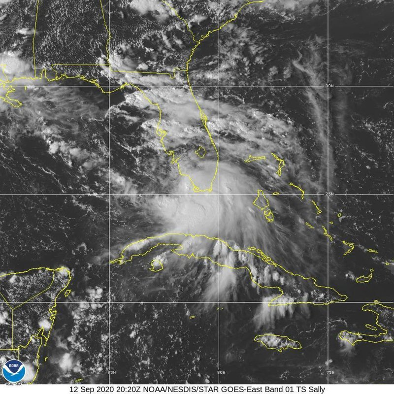
This Saturday, Sept. 12, 2020 image provided by NOAA shows the formation of Tropical Storm Sally. Tropical Storm Sally has formed off south Florida, becoming the earliest 18th-named tropical storm on record in a busy Atlantic hurricane season. (NOAA via AP)
Read more: https://apnews.com/482d975ef43dadb8c1d6ffdfa12d4545
 = new reply since forum marked as read
Highlight:
NoneDon't highlight anything
5 newestHighlight 5 most recent replies
= new reply since forum marked as read
Highlight:
NoneDon't highlight anything
5 newestHighlight 5 most recent replies

BumRushDaShow
(129,400 posts)since that one's path seems to have it recurving back to the east as its move north after making landfall and we often get rain from the remnants of these storms as they move with a front.
This existing set of threats is wild! "Teddy" may be coming soon.

Baclava
(12,047 posts)BumRushDaShow
(129,400 posts)it was just blobs of convection - even on LWIR. I couldn't even find any center of circulation through all that. 
At least Paulette has some mojo hurricane spin and even TD-20 is trying to get its spin-on, despite the interference from the latest off the African coast that may end up being TD-21.
Baclava
(12,047 posts)
BumRushDaShow
(129,400 posts)and the previous mission in there seemed to show a wild choice for where to deploy the dropsondes -

Baclava
(12,047 posts)15-20 inches of rain, 6-9 ft of storm surge for MS delta area, SE LA
Paulette to hit Bermuda directly as a Cat 2/3
BumRushDaShow
(129,400 posts)because the Western Atlantic Ridge ("Bermuda High" ) is usually right nearby. But right now, that has been displaced to the north and east and so things are rolling around accordingly to reflect that.

Almost a year ago this month, Bermuda was brushed by TS-Jerry, that had fortunately never made it beyond TS status and had become post-tropical by the time it reached Bermuda (due to being sheared apart and interacting with other systems in the area like Erin and Karen).
MW of Jerry on its approach to Bermuda -
 v
v

ananda
(28,875 posts)
ananda
(28,875 posts)
Baclava
(12,047 posts)
Marthe48
(17,015 posts)n/t
beachbumbob
(9,263 posts)those are going to be the issues over next month or more

scipan
(2,356 posts)Prepared than they were for Katrina. I remember the pumps got flooded so stopped working then.