Hurricane Center: Sally forecast shifts east, further away from metro New Orleans
Source: Times-Picayune
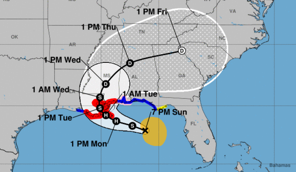
The forecast track for Tropical Storm Sally has shifted east Sunday night away from southeast Louisiana, reversing a westward trend earlier in the day and possibly keeping the eventual hurricane’s strongest winds, heaviest rain and highest storm surge away from metro New Orleans.
It is still expected to form into a hurricane in the Gulf of Mexico on Monday.
The National Hurricane Center said in its 10 p.m. update Sally was located approximately 140 miles southwest of Panama City, Florida and moving northwest at 8 mph.
It had maximum sustained wind gusts of 60 mph.
Read more: https://www.nola.com/news/hurricane/article_bc64d506-f62a-11ea-9a10-f7364bb7596d.html
 ?
? = new reply since forum marked as read
Highlight:
NoneDon't highlight anything
5 newestHighlight 5 most recent replies
= new reply since forum marked as read
Highlight:
NoneDon't highlight anything
5 newestHighlight 5 most recent replies

gristy
(10,667 posts)And peak rainfall is in fact centered on NO. Yikes.
https://www.nhc.noaa.gov/refresh/graphics_at4+shtml/215807.shtml?rainqpf#contents

KY_EnviroGuy
(14,492 posts)New Orleans Metro area is 3750 sq-miles = 103 billion sq.-ft, therefore 20" rainfall is 172 billion cu-ft. = 1.3 trillion gallons.
and....
New Orleans City limits area is 350 sq-miles = 9.7 billion sq.-ft, therefore 20" rainfall is 16 billion cu-ft. = 121 billion gallons.
Source of area/volume info: Wikipedia and 20" rainfall = 1.67 ft. and 1-cu-ft water = 7.5 gallons.
Darn good thing the City has all pumps working!
KY

fleur-de-lisa
(14,624 posts)we are expected to get 2"-4" of rain in New Orleans. All 99 of the pumps are in working order and should easily remove the rain. Those inside the levee system should be protected from storm surge. Of course we will get wind over the next two days, nothing can be done about that.
I think Mississippi and Alabama will bear the brunt of this.
gristy
(10,667 posts)Not so good for MS and AL.
fleur-de-lisa
(14,624 posts)I want to be put in a medically induced coma until 2020 is over.
KY_EnviroGuy
(14,492 posts)
Certainly may shift again but now looks like mainland landfall near Bay St. Louis or Gulfport, MS.
KY

BumRushDaShow
(129,063 posts)
Big blobs of convection along the right front quadrant are theorized to have been a cause for the track change.
Link to tweet
TEXT
@TropicalTidbits
New data from the evening recon flight into #Sally indicates that the low-level center is getting tugged toward the new convective burst on the NE side, a trend that would likely lead to intensification if it persists overnight.
Image
8:35 PM · Sep 13, 2020
From the last recon (showing the width of what could become a central eye if the convective blobs wrap around the swirl to its west) -

Baclava
(12,047 posts)BumRushDaShow
(129,063 posts)Still looks blobby but the CoC seems to have moved eastward towards where all that high-topped convection was. That means the landfall may be more into Alabama around Mobile.
Baclava
(12,047 posts)BumRushDaShow
(129,063 posts)
But whoever ends up in the right front quadrant at landfall is screwn. At least it won't be a Laura in terms of winds but will be a serious soaker with all that convection.

Baclava
(12,047 posts)Of course losing power is always the worst, I'm 5 mi inland
BumRushDaShow
(129,063 posts)The only good thing here is that it has taken so long to strengthen, has been someone unstable, and has been slow moving churning up the water (meaning the upwelling of cooler water), hopefully it won't go into RI overdrive.
All I can say is good luck! 

(we may get a glancing line of rain up here in the Philly area from the remnants but that will depend on whether that big Canadian High to our north continues to suppress the whole mess to our south or not).
Baclava
(12,047 posts)
Sherman A1
(38,958 posts)As slow as it us moving.
Baclava
(12,047 posts)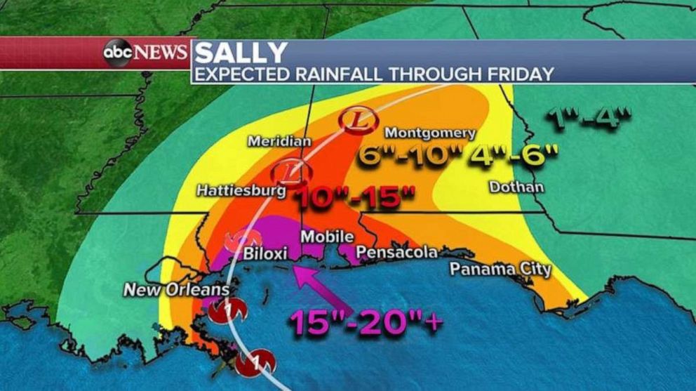
Baclava
(12,047 posts)BumRushDaShow
(129,063 posts)

Baclava
(12,047 posts)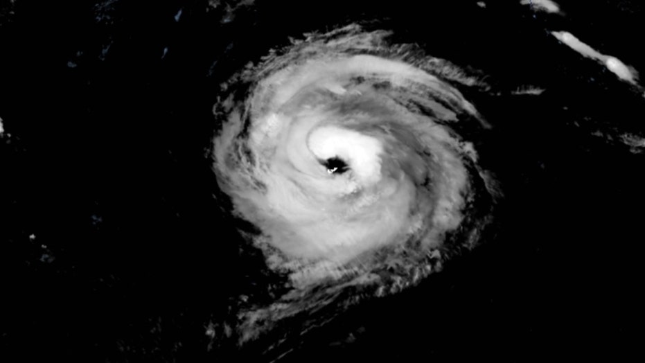 ?ve=1&tl=1
BumRushDaShow
(129,063 posts)and you could see the entire island through the top! 
