Welcome to DU!
The truly grassroots left-of-center political community where regular people, not algorithms, drive the discussions and set the standards.
Join the community:
Create a free account
Support DU (and get rid of ads!):
Become a Star Member
Latest Breaking News
General Discussion
The DU Lounge
All Forums
Issue Forums
Culture Forums
Alliance Forums
Region Forums
Support Forums
Help & Search
The DU Lounge
Related: Culture Forums, Support Forums
InfoView thread info, including edit history
TrashPut this thread in your Trash Can (My DU » Trash Can)
BookmarkAdd this thread to your Bookmarks (My DU » Bookmarks)
6 replies, 904 views
ShareGet links to this post and/or share on social media
AlertAlert this post for a rule violation
PowersThere are no powers you can use on this post
EditCannot edit other people's posts
ReplyReply to this post
EditCannot edit other people's posts
Rec (8)
ReplyReply to this post
6 replies
 = new reply since forum marked as read
Highlight:
NoneDon't highlight anything
5 newestHighlight 5 most recent replies
= new reply since forum marked as read
Highlight:
NoneDon't highlight anything
5 newestHighlight 5 most recent replies
= new reply since forum marked as read
Highlight:
NoneDon't highlight anything
5 newestHighlight 5 most recent replies
How about a little boat ride on the Potomac? (Original Post)
Kingofalldems
May 2018
OP

cilla4progress
(24,779 posts)1. Impressive!
👍

appalachiablue
(41,177 posts)2. Play the Video- Holy Moly! That's really rough..No rafting..evah


mercuryblues
(14,544 posts)3. ok
Who threw the rocks in there and displaced all that water?
Just asking for Mo Brooks.

mahatmakanejeeves
(57,642 posts)4. Harrumph. It's no 1936 flood.
Great Falls (Potomac River)
The Flood of March 17-19 1936
National Building Museum event will discuss how D.C. could fare in a 500-year storm
The free event on October 18 will feature four speakers who will discuss how the District prepares for heavy floods
By Michelle Goldchain@goldchainam Oct 17, 2017, 12:07pm EDT

A photo showing the last major flood in Washington, D.C., in March 1936. Photo via Library of Congress/Harris & Ewing
Northeast flood – Spring 1936
Rain concurrent with snowmelt set the stage for this flood. It affected the entire state of New Hampshire. In Maine, a major flood washed out railroad tracks along the Androscoggin River east of Bethel and the industrial section of Rumford. Jay saw its mills and factories along the river damaged. The East Turner bridge was again destroyed. The iron bridge between Lisbon Falls and Durham washed away. Along the Kennebec River, the Ticonic bridge was washed downstream at Waterville, Maine. In all, damage totaled US$113 million (1936 dollars), and 24 people were killed. Damage was significant along the C&O Canal during the greatest of all Potomac River floods. The flood carried off many of the bridges along the Potomac from Harpers Ferry, West Virginia to Hancock, Maryland. Pittsburgh suffered the worst floods in its history.

Anacostia River, during the 1936 Potomac River flood.
Rain concurrent with snowmelt set the stage for this flood. It affected the entire state of New Hampshire. In Maine, a major flood washed out railroad tracks along the Androscoggin River east of Bethel and the industrial section of Rumford. Jay saw its mills and factories along the river damaged. The East Turner bridge was again destroyed. The iron bridge between Lisbon Falls and Durham washed away. Along the Kennebec River, the Ticonic bridge was washed downstream at Waterville, Maine. In all, damage totaled US$113 million (1936 dollars), and 24 people were killed. Damage was significant along the C&O Canal during the greatest of all Potomac River floods. The flood carried off many of the bridges along the Potomac from Harpers Ferry, West Virginia to Hancock, Maryland. Pittsburgh suffered the worst floods in its history.
Anacostia River, during the 1936 Potomac River flood.
Potomac River
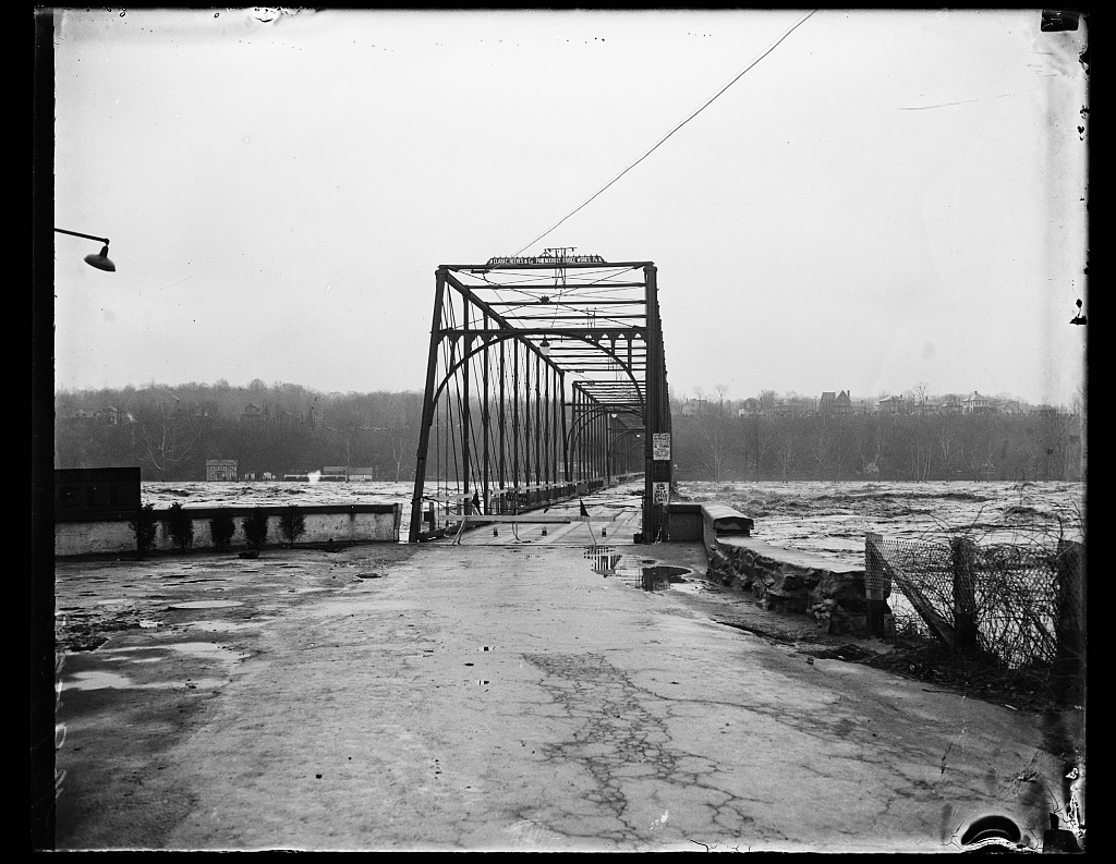
The Potomac River surges over the deck of Chain Bridge during the historic 1936 Flood. The bridge was so severely damaged by the raging water, and the debris it carried, that its superstructure had to be re-built; the new bridge was opened to traffic in 1939. (This photograph was taken from a vantage point on Glebe Road in Arlington County, Virginia. The houses on the bluffs in the background are located on the Potomac Palisades of Washington, DC.)
The Potomac River surges over the deck of Chain Bridge during the historic 1936 Flood. The bridge was so severely damaged by the raging water, and the debris it carried, that its superstructure had to be re-built; the new bridge was opened to traffic in 1939. (This photograph was taken from a vantage point on Glebe Road in Arlington County, Virginia. The houses on the bluffs in the background are located on the Potomac Palisades of Washington, DC.)
The Flood of March 17-19 1936
National Building Museum event will discuss how D.C. could fare in a 500-year storm
The free event on October 18 will feature four speakers who will discuss how the District prepares for heavy floods
By Michelle Goldchain@goldchainam Oct 17, 2017, 12:07pm EDT
A photo showing the last major flood in Washington, D.C., in March 1936. Photo via Library of Congress/Harris & Ewing

Kingofalldems
(38,489 posts)5. Wow. My mother lived through that.
I don't remember her ever talking about it but that was some bad stuff.
mahatmakanejeeves
(57,642 posts)6. Mine too.
I'm sure you've seen the marker at Great Falls that indicates the height of the flood waters.