Welcome to DU!
The truly grassroots left-of-center political community where regular people, not algorithms, drive the discussions and set the standards.
Join the community:
Create a free account
Support DU (and get rid of ads!):
Become a Star Member
Latest Breaking News
General Discussion
The DU Lounge
All Forums
Issue Forums
Culture Forums
Alliance Forums
Region Forums
Support Forums
Help & Search
The DU Lounge
Related: Culture Forums, Support ForumsUnreality Survivor Tee Vee
BWAHAHAHAHAHAHAHA!!!
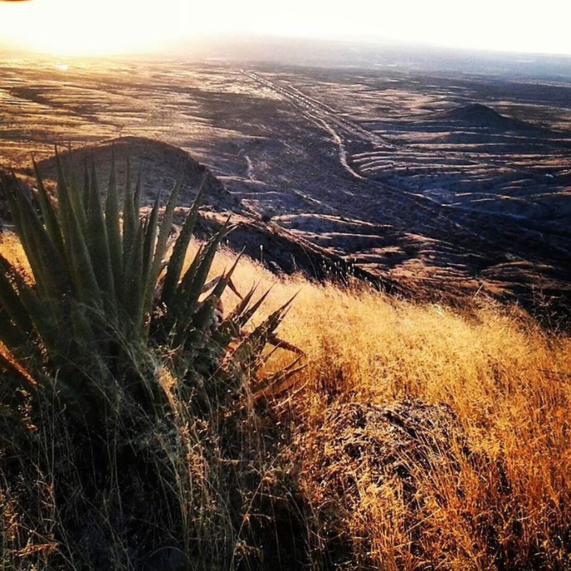
at the very end of this episode (really, the last two minutes) after crossing some flat terrain that magically changes plant communities depending on camera angle, this clown hikes a barren, loose, rocky slope up the back side of a mountain before topping it and seeing signs of civilization.
that flat and the rocky slope are not there. How do I know? The top of the mountain is right behind my house and I have been there many times. In fact just at the end when he starts to walk towards the "city" lights, the camera swings down and a bit to the right and you can glimpse my house and the garage/workshop in the lower right hand corner.
LOL, there is a road going right up the way he supposedly came, and there are at least 5 huge communications towers up there, along with a helipad. Not to mention if he was actually in the nearest mountains with pines, climbing through holes and hanging from a rope to climb to a rock pinnacle for no reason (so obvious there is a trail AROUND those obstacles), they would be the Dragoons and there would be no reason to climb the relatively isolated peak that this is. You would follow a ranch road to a house, a drainage down to the San Pedro River, OR follow the the freaking railroad tracks between the two "sky islands" to Benson, the little town that's lights are in the path of freaking Interstate 10, which is the traffic down below. To get from the nearest mountain that has pine trees to the top of the mountain behind the house, you HAVE to cross at least 4 barbed wire fences and a double set of heavily used railroad tracks.

InfoView thread info, including edit history
TrashPut this thread in your Trash Can (My DU » Trash Can)
BookmarkAdd this thread to your Bookmarks (My DU » Bookmarks)
3 replies, 739 views
ShareGet links to this post and/or share on social media
AlertAlert this post for a rule violation
PowersThere are no powers you can use on this post
EditCannot edit other people's posts
ReplyReply to this post
EditCannot edit other people's posts
Rec (0)
ReplyReply to this post
3 replies
 = new reply since forum marked as read
Highlight:
NoneDon't highlight anything
5 newestHighlight 5 most recent replies
= new reply since forum marked as read
Highlight:
NoneDon't highlight anything
5 newestHighlight 5 most recent replies
= new reply since forum marked as read
Highlight:
NoneDon't highlight anything
5 newestHighlight 5 most recent replies
Unreality Survivor Tee Vee (Original Post)
Kali
Jun 2015
OP
struggle4progress
(118,295 posts)1. Desert Adventures!
What are those big pylon-like things?
Don't even look at them! They're Eskimo ruins!
Should we follow the road or use an Apache bow to throw a rope-line between the pinnacles?
The road could be a mirage!
Don't even look at them! They're Eskimo ruins!
Should we follow the road or use an Apache bow to throw a rope-line between the pinnacles?
The road could be a mirage!

Kali
(55,014 posts)2. OK, I was not going to watch the whole load of stupidity, but I couldn't resist
the playa that he crosses with the improvised sail from a "wrecked" ultralight, uh the mountains he heads for are INTO the prevailing winds. there are dunes in the other direction, you know, the way the wind actually blows. (also the train tracks cross that playa in a very obvious manner)
more comedy gold (besides apparently taking the worst possible "path" anywhere he wants to go) include eating a scorpion (out in the middle of the day) and leaving a perfectly good rattlesnake? climbing and hanging from a rough hunk of rock instead of just sleeping by his fire? WTF?
I would name this show "Taking the Worst Path" an exploration of hiking over rocks and through thick brush instead of just going around.
Kali
(55,014 posts)3. my son took a photo of the same view a while back