Colorado
Related: About this forumincredible satellite photo of our beautiful state
a snippet of the shot
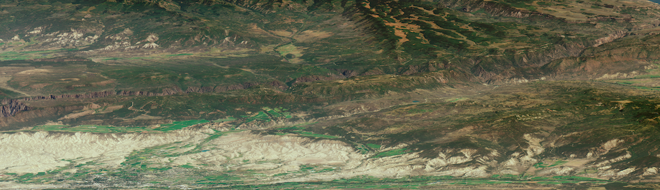
In the south of the image, you can see Black Canyon of the Gunnison, a gorge so deep that its bottom receives only 33 minutes of sunlight per day.
WorldView-3 is one of the most advanced privately owned Earth-observing satellites in use. It’s owned and operated by DigitalGlobe, a corporation that supplies imagery to the U.S. National Geospatial-Intelligence Agency and Google Maps. If you’ve seen an orbital view of the planet that showed streets and buildings, it’s likely you were looking at an image captured by WorldView-3 or another DigitalGlobe satellite.
...
Since most satellite images are taken looking directly down, few satellite images give this sense of the landscape. Whereas Google Maps is flat and map-like, this shows a planetary surface where hundreds of thousands of people live. Mountains and terrain—the American Rockies—jut up and obscure the land. Canyons disfigure it.
This picture, angled southwest-northeast, captures a huge swath of the state of Colorado: almost everything between Montrose and Fort Morgan.
http://www.theatlantic.com/technology/archive/2015/12/a-new-kind-of-landscape-photography/421287/?utm_source=SFFB
 = new reply since forum marked as read
Highlight:
NoneDon't highlight anything
5 newestHighlight 5 most recent replies
= new reply since forum marked as read
Highlight:
NoneDon't highlight anything
5 newestHighlight 5 most recent replies

justhanginon
(3,290 posts)When you look at some of the things that are rather esoteric to laymen like myself that are accomplished in various fields you soon come to realize there are some really, really smart people out there.

fizzgig
(24,146 posts)the wonders of our world never cease to amaze me.

classof56
(5,376 posts)Incredible scenery, that's for sure, although of course Denver's a lot bigger than when I was a kid. That was when the D&F tower was the tallest building downtown. I climbed it once when I was a young teenager. What a memory!
Cheers.

Gumboot
(531 posts)The resolution is astounding. I just spent an hour zooming in and out, marvelling at our state's mountains, canyons, deserts and plains. And you can even see the planes parked over at DIA!
I'm sure I had a whole list of things to do this morning... naaaaah, they can wait. 