Environment & Energy
Related: About this forumI Don't Say This Lightly - Stunning Kos Article On Arctic Storm's Impact On Salinity, Warm Upwelling
A huge, long-lived Arctic ocean storm has decimated the sea ice area which was melting out at a record rate before the high waves and winds shattered the Siberian side of the ice cap.
 ?1344622149
The record minimum ice area will almost certainly be broken well before ice starts to rebuild in mid to late September because weather patterns remain favorable for continued melting. Before the extraordinary melt season of 2007 summer storms kept the sea ice cool and cloudy, preserving the ice cap. In 2007 most of the thick multi-year sea ice was lost to melting and steady winds that blew large amounts of ice out of the Arctic. Now the thin ice is vulnerable to storms which break up the ice and mix it with water that's been heated by the summer sun in ice free areas. Large areas of open water this summer set the scene for the catastrophic effects of this exceptional storm. Because sea ice is so much more reflective than open water, progressive loss of sea ice establishes a feed back loop of more warming and ice loss. In previous posts I have called this feedback loop a death spiral for Arctic sea ice because it is rapidly leading the Arctic ocean to ice free Septembers.
 ?1344622035
The sea ice area for August 9 was lower this year than in previous years as determined by Cryosphere Today of the University of Illinois. The rate of area loss is the highest since measurements began in 1979.
Because large storms blow sea ice away from the storm's center, like a centrifuge, the sea ice extent, which includes all areas with greater than 15% ice, is slower to respond to storms than sea ice area. In 2007 ice was compacted by high pressure, minimizing the sea ice extent. This year is the opposite of 2007 in terms of storminess, but both years have seen rapid melting. The slushy, thin ice blown out from this storm is likely to melt out in the area offshore of Alaska and Siberia, likely leading to a drop in sea ice area over the next few weeks. Sea ice extent will probably reach a record minimum this year a week or two later than the date the sea ice area is broken.
Disturbingly, a feedback loop no one expected to see any time in the near future may have been started by this storm. The Arctic ocean is protected from melting from below by a surface layer of cold fresh water that flowed in from Siberian rivers. A layer of relatively warm, salty water that originated in the north Atlantic lies below the fresh cold surface water. Preliminary, uninterpreted data may show that that stratification has been broken by the intense storm. Hurricanes and large winter storms are well known to cause upwelling of cool water from deeper layers. That is normal. However, if warm salty water is upwelled in the Arctic ocean, it could have a large positive effect on the heat balance. It could be another destructive feedback loop for sea ice. It could significantly amplify the rate of Arctic warming and global climate change. We don't yet know that this feed back loop has been triggered, but an observation on Neven's blog needs to be followed up by researchers to determine what has just taken place in the Arctic. When I examined the buoy profiles he linked to, I saw possible evidence of upwelling, too. This is a problem I didn't think we would need to worry about until I saw the size and duration of this storm.
I understand Neven's position that we should wait and see what the impact of the storm will really be after the clouds are gone, but let me tell you that I have a very bad feeling about this one.
Last year, with the "flash melt" during the November storm, I was confident that the "flash melt" was mostly caused by sea water flushing over the ice, which only temporarily (and artificially) confuses the satellite sensors in believing that large swats of ice have turned to water.
At that time, the ocean flux data from ITP buoys revealed that ocean water was stirred up down to 25 meter or so, which caused some salty water to bubble up to under the ice, with the potential to 'flash' melt out about 10 cm from the bottom of the ice pack.
This storm however, is completely different.
For starters, freezing has not yet started seriously, so any flushed-over ice will take longer to re-appear on the SSMI satellite instruments. Second, the ice pack in the Western Arctic was already heavily fragmented even before this storm even started. There were plenty of polynia and areas where ice concentration was no more than some 50 %. This means that the "flash melt" area starts to behave much more like "open ocean" than an area with a semi-solid ice pack.
But even worse, this storm seems to have stirred up not just the upper halocline at 20-75 meters, but even the lower halocline at a 200-500 meter depth. Two separate ITP buoys, separated by a few hundred km, record this disturbance so it is not just a local event :
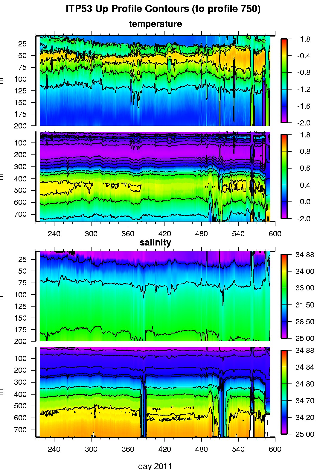
 ?1344628974
Preliminary, automated, uninterpreted buoy data from the Arctic ocean area affected by the huge storm.
http://www.whoi.edu/...
Several studies show that the upper halocline can be disturbed down to some 50 meters, and these are great reads :
http://www.whoi.edu/...
http://www.whoi.edu/...
but I've not seen anything like this disturbance down to 500 meter over a wide area ever before in the ITP records.
What does this mean ? Well, the stratification layers in the West Arctic in the "flash melt" zone seem to be completely eliminated for the moment. This brings up 'warm' and more importantly, 'salty' water to the surface (and cool, fresh water downward). The saline anomaly at the surface is disturbing : it increased from 25 psu to about 31.5 psu over the past couple of days. That means that the melting temp of sea ice just reduced by 0.5 C, and this is even without counting the increase in water temperature towards the surface that the stirring down to 500 meters causes.
It's hard to estimate how much ice melt this will cause, but since the storm still is causing significant water movement along the ice (ITP53 reports rock-and-rolls of 0.8 m/sec) as well as up/down welling, and because the crumbled ice above has a large surface area to absorb the heat, melting may resemble sugar in a stirred cup of tea right now.
The real important question is, how long will this de-stratified state persist ? The short answer is that we simply don't know. Ocean models (even without ice cover) are simply not yet capable of simulating deep ocean turbulence effects after a storm. Here is a good read :
http://curry.eas.gatech.edu/...
So after all is said and done, it seems that Neven was right and we need to wait out this storm to assess what it's long-term effects really will be. But at the same time, the de-stratification this storm has caused down to 500 meter depth and the mixing of salinity and heat content throughout that column over the area of this storm (about 1 million km^2) will most certainly have caused very significant damage to the already fragmented ice pack, to the point that it become hard to believe
that the entire area or even part of it will somehow magically re-appear on the satellite record.
I think the "flash melt" area is knocked out for the season, and on top of that this storm will leave a lot of salty water behind at the surface, which will eliminate small pockets of ice remaining and make it harder for the area to freeze up in fall.
What do you guys think ?
Posted by: Rob Dekker | August 10, 2012 at 10:12
EDIT
http://www.dailykos.com/story/2012/08/10/1118634/-Sea-Ice-Decimated-Huge-Storm-May-Have-Broken-Arctic-Ocean-Stratification
 = new reply since forum marked as read
Highlight:
NoneDon't highlight anything
5 newestHighlight 5 most recent replies
= new reply since forum marked as read
Highlight:
NoneDon't highlight anything
5 newestHighlight 5 most recent replies

dipsydoodle
(42,239 posts)The impacts of increased open water in the Beaufort Sea were investigated for a summer Arctic storm in 2008 using a coupled atmosphere-ice-ocean model. The storm originated in northern Siberia and slowly moved into the Beaufort Sea along the ice edge in late July. The maximum wind associated with the storm occurred when it was located over the open water near the Beaufort Sea coast, after it had moved over the Chukchi and Beaufort Seas. The coupled model system is shown to simulate the storm track, intensity, maximum wind speed and the ice cover well. The model simulations suggest that the lack of ice cover in the Beaufort Sea during the 2008 storm results in increased local surface wind and surface air temperature, compared to enhanced ice cover extents such as occurred in past decades. In addition, due to this increase of open water, the surface latent and sensible heat fluxes into the atmosphere are significantly increased. However, there were no significant impacts on the storm track. The expanded open water and the loss of the sea ice results in increases in the surface air temperature by as much as 8°C. Although the atmospheric warming mostly occurs in the boundary layer, there is increased atmospheric boundary turbulence and downward kinetic energy transport that reach to mid-levels of the troposphere and beyond. These changes result in enhanced surface winds, by as much as ?4 m/s during the 2008 storm, compared to higher ice concentration conditions (typical of past decades). The dominant sea surface temperature response to the storm occurs over open water; storm-generated mixing in the upper ocean results in sea surface cooling of up to 2°C along the southern Beaufort Sea coastal waters. The Ekman divergence associated with the storm caused a decrease in the fresh water content in the central Beaufort Sea by about 11 cm.
http://www.agu.org/pubs/crossref/2012/2011JD016985.shtml

Jim__
(14,077 posts)... and I'd say we've crossed a line.
Vast methane 'plumes' seen in Arctic ocean as sea ice retreats:
Dramatic and unprecedented plumes of methane - a greenhouse gas 20 times more potent than carbon dioxide - have been seen bubbling to the surface of the Arctic Ocean by scientists undertaking an extensive survey of the region.
The scale and volume of the methane release has astonished the head of the Russian research team who has been surveying the seabed of the East Siberian Arctic Shelf off northern Russia for nearly 20 years.
In an exclusive interview with The Independent, Igor Semiletov of the International Arctic Research Centre at the University of Alaska Fairbanks, who led the 8th joint US-Russia cruise of the East Siberian Arctic seas, said that he has never before witnessed the scale and force of the methane being released from beneath the Arctic seabed.
"Earlier we found torch-like structures like this but they were only tens of metres in diameter. This is the first time that we've found continuous, powerful and impressive seeping structures more than 1,000 metres in diameter. It's amazing," Dr Semiletov said.
...

silverweb
(16,402 posts)[font color="navy" face="Verdana"]And without seriously unified efforts, it may be too late to delay or stop it.

Junkdrawer
(27,993 posts)"The upwelling from 200-500 meter all the way to the surface, recorded simultaneously on two different ITPs (and coinciding with a known and significant storm overhead) is, as far as I can see, unprecedented in the ITP record"
Quite so. And I think this can be perhaps understood as a consequence of widely fragmented ice in the arctic.
Wind is plainly driving this ocean mixing. The current state of fragmented ice perhaps ENHANCES the ability of wind to create mixing. Due to Coriolis forces with Ekman pumping involved, any lateral movement of surface water promotes mixing with deeper waters.
When the arctic is largely a solid, immobile ice sheet, wind cannot transfer momentum to the water. In ice-free water, wind has to kick up some waves to be able to transfer momentum to the water.
But when fragmented floes are present, each irregular piece of ice acts as a sail in the wind, so the wind transfers momentum more readily to the surface. And each piece of ice, being 90 percent submerged, quite effectively transfers that momentum to the water. With winds moving in essentially a single direction in any given area, vast volumes of surface water are more readily put into motion. The difference in motion between the surface and deep water inevitably creates mixing.
It's a positive feedback mechanism, not for climate, but for destruction of sea ice. The thinner and more fragmented the ice, the more readily wind creates mixing, which makes the ice thinner and more fragmented. Until, that is, the ice is gone.
http://neven1.typepad.com/blog/2012/08/arctic-summer-storm-open-thread.html?cid=6a0133f03a1e37970b0177440b63e5970d#comment-6a0133f03a1e37970b0177440b63e5970d
Basically, each of the broken pieces have 10% above water acting as sails with the below water 90% acting as stirring spoons. How much methane will be released by all this stirring is anyone's guess.

CRH
(1,553 posts)are now useless, adding to less reflected light and more lingering heat, trapped within the atmosphere. This certainly invites feedback loop speculation.
Ah, for a person who shouldn't bitch, I sure feel like bitching.
Response to hatrack (Original post)
Post removed

phantom power
(25,966 posts)Please enjoy your very very limited remaining time here at DU


XemaSab
(60,212 posts)

Systematic Chaos
(8,601 posts)[IMG] [/IMG]

hatrack
(59,587 posts)Was it:
(A) Pointy-headed saahntists, whadda THEY know!
(B) Al Gore's fat and he has a big ol' house!!
(C) I was just reading Anthony Watts, and he said (insert bullshit here).
??????
phantom power
(25,966 posts)"polar bear populations are at a record" -- a totally new one for me!
and a bunch of "ice free arctic == mega resource extraction in the arctic == trillions of dollars of Bizness Win11!!1!!"