Welcome to DU!
The truly grassroots left-of-center political community where regular people, not algorithms, drive the discussions and set the standards.
Join the community:
Create a free account
Support DU (and get rid of ads!):
Become a Star Member
Latest Breaking News
General Discussion
The DU Lounge
All Forums
Issue Forums
Culture Forums
Alliance Forums
Region Forums
Support Forums
Help & Search
Environment & Energy
Related: About this forumIs there even less Arctic sea ice than the satellites show?
http://www.guardian.co.uk/environment/blog/2012/sep/13/less-arctic-sea-ice-satellites?intcmp=122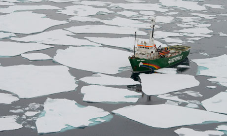
The Arctic Sunrise ship from the air during an expedition to the Arctic to document the lowest sea ice level on record. Photograph: Daniel Beltra/Greenpeace
Where is the ice? We are now at 83.20N which is very close to the north pole yet still there is no continuous ice cover (head here for more on my journey through the Arctic). We are mostly among small, thin, one- and two-year-old floes, with very little of the older, harder and more resilient "multiyear", or permanent ice that you would expect in these latitudes.
Our ice pilot, Arne Sorensen, went up in the helicopter and found little change even as far north as 83.50 – just 350 miles from the pole. Just finding an ice floe big enough to moor the 50 metre-long Arctic Sunrise for the scientists aboard to conduct their experiments has proven harder than expected – something that many think is almost unheard of at this latitude.
The obvious inference is that the ice has retreated far further this year than before and we will need to check previous years' satellite data to confirm this. But there may actually be far less ice in the Arctic than the satellite figures suggest.
In winter when the sea surface is frozen up here, scientists can be pretty sure how much ice there is. But in the summer months when the ice is melting and there's much more water around, the satellite can become confused.
InfoView thread info, including edit history
TrashPut this thread in your Trash Can (My DU » Trash Can)
BookmarkAdd this thread to your Bookmarks (My DU » Bookmarks)
6 replies, 1385 views
ShareGet links to this post and/or share on social media
AlertAlert this post for a rule violation
PowersThere are no powers you can use on this post
EditCannot edit other people's posts
ReplyReply to this post
EditCannot edit other people's posts
Rec (9)
ReplyReply to this post
6 replies
 = new reply since forum marked as read
Highlight:
NoneDon't highlight anything
5 newestHighlight 5 most recent replies
= new reply since forum marked as read
Highlight:
NoneDon't highlight anything
5 newestHighlight 5 most recent replies
= new reply since forum marked as read
Highlight:
NoneDon't highlight anything
5 newestHighlight 5 most recent replies
Is there even less Arctic sea ice than the satellites show? (Original Post)
xchrom
Sep 2012
OP
I thought that was why the extent measurements use thresholds like >= 30% coverage, but...
phantom power
Sep 2012
#1

phantom power
(25,966 posts)1. I thought that was why the extent measurements use thresholds like >= 30% coverage, but...
on the other hand I bet that they never designed the measuring protocols with the idea that 3/4 of the ice at the pole was slush.

CRH
(1,553 posts)2. I've been wondering the same thing, ...
On the other picture with the imaging of the ice, I have wondered what that fiery red or 60% ice looks like. Is it something like the photograph above with many small floes with lots of water in between, or is it so slushy you couldn't walk on it? Does the 60% represent an actual ice density after partial melt and loss of salt and other? Or is it a location that has 60% ice and 40% water, by area? I wish I could see actual pictures of ice represented by the different colors.

XemaSab
(60,212 posts)3. This is the area between the North Pole and the so-called "Laptev Bite," which is that hole
http://rapidfire.sci.gsfc.nasa.gov/imagery/subsets/?subset=Arctic_r04c04.2012256.terra
If you click on the 250m resolution you can zoom way, way, way in.
(Edit for a slightly clearer shot.)
If you click on the 250m resolution you can zoom way, way, way in.
(Edit for a slightly clearer shot.)
CRH
(1,553 posts)4. Thank you XemaSab, ...
I've viewed the photos and will now isolate that area on the ice imagery maps. hrh

pscot
(21,024 posts)5. I think you want to spell that "bight"

pscot
(21,024 posts)6. If that picture was taken less than 7 degrees
from the Pole, they must be well within the red.