Environment & Energy
Related: About this forumPine Island Glacier crack - NASA
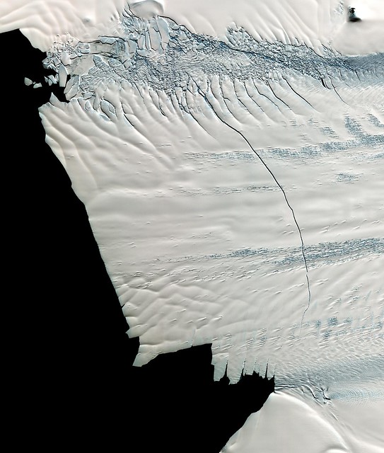
In mid-October 2011, NASA scientists working in Antarctica discovered a massive crack across the Pine Island Glacier, a major ice stream that drains the West Antarctic Ice Sheet. Extending for 19 miles (30 kilometers), the crack was 260 feet (80 meters) wide and 195 feet (60 meters) deep. Eventually, the crack will extend all the way across the glacier, and calve a giant iceberg that will cover about 350 square miles (900 square kilometers). This image from the Advanced Spaceborne Thermal Emission and Reflection Radiometer (ASTER) instrument on NAS's Terra spacecraft was acquired Nov. 13, 2011, and covers an area of 27 by 32 miles (44 by 52 kilometers), and is located near 74.9 degrees south latitude, 101.1 degrees west longitude.
Image Credit: NASA/GSFC/METI/ERSDAC/JAROS, and U.S./Japan ASTER Science Team
NASA image use policy.
NASA Goddard Space Flight Center enables NASA’s mission through four scientific endeavors: Earth Science, Heliophysics, Solar System Exploration, and Astrophysics. Goddard plays a leading role in NASA’s accomplishments by contributing compelling scientific knowledge to advance the Agency’s mission.
http://www.flickr.com/photos/gsfc/6796129787/
 = new reply since forum marked as read
Highlight:
NoneDon't highlight anything
5 newestHighlight 5 most recent replies
= new reply since forum marked as read
Highlight:
NoneDon't highlight anything
5 newestHighlight 5 most recent replies

NMDemDist2
(49,313 posts)Blappy
(84 posts)If I'm reading the website correctly, the crack was discovered in October 2011. The picture is dated Jan 31, 2012 (yesterday).

Viking12
(6,012 posts)"This image from the Advanced Spaceborne Thermal Emission and Reflection Radiometer (ASTER) instrument on NAS's Terra spacecraft was acquired Nov. 13, 2011"

tabatha
(18,795 posts)
padruig
(133 posts)While this is interesting it is not news worthy without the back-story ...
Pine Island is widely considered the weak underbelly of the Western Antarctic Ice Sheet system. Pine Island is isolated, its a long flight to get to it and the surface cracking makes it difficult to land upon safely.
It's central stream is the confluence of several source streams. Its thickness runs about 1.2 miles, although I've seen some citations showing up to 2 miles in some sections.
Historically we've seen Pine Island as a static system, then in the 1990's we began to find it had started to move. In recent years we've compared radar observations with surface GPS measurements and find that Pine Island is accelerating.
The most recent measurements I had seen indicated that it was moving at a rate of 1 linear foot a day.
Then a couple years ago the British sent an unmanned autonomous submersible under the tongue of the glacier outflow and discovered that Pine Island had been under cut by the gradual heating of the ocean. The undercutting is quite serious, it means that the outward tongue of ice is no longer supported by the sea bed and is flexing under tidal stresses. This is why you see the crack you see in the photograph. The actual distance before you see the glacier return to its grounding line (the point where the glacial ice is supported by the sea bed) is two to three times farther back.
The WAIS represents about 10% of all the glacial mass of Antarctica as a whole.
To read more about it:
Basal Conditions http://nora.nerc.ac.uk/11087/1/s6.pdf
Acceleration http://www-radar.jpl.nasa.gov/glacier/Papers/34A037.pdf
Crevassing http://www.igsoc.org/annals/v51/55/a55a006.pdf
Acceleration http://nora.nerc.ac.uk/7294/1/tc-3-125-2009.pdf
The NASA Flickr site that I check daily, usually has a link to a site with more detail. This post did not.

muriel_volestrangler
(101,361 posts)http://news.nationalgeographic.com/news/2012/120202-crack-antarctica-iceberg-science-glacier/
3000m/year is about 8m/day; or about 1 foot/hour.

tclambert
(11,087 posts)Whenever anything breaks off of Antarctica, you're supposed to compare it to Rhode Island. It's a rule or something.
truebrit71
(20,805 posts)..
