Archaeologists may have solved mystery of Peru's 'band of holes'
Archaeologists may have solved mystery of Peru's 'band of holes'
By Karen Graham May 1, 2016 in Science .
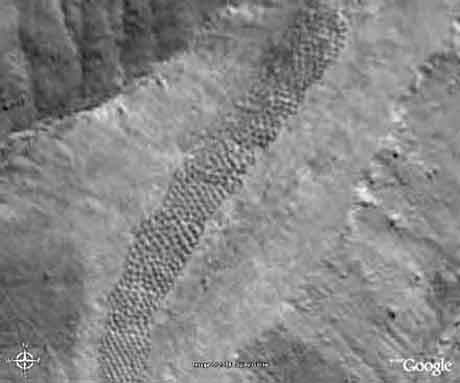
A strange-looking construction in the Pisco Valley on the Nazca Plateau in Peru was documented by aerial photography in 1933. No one has ever been able to figure out what the 5,000 or so strange looking holes could possibly be, until now.
From above the Earth, looking down, the mile-long strip of land with the strange marks looks very much like the tire tracks left by a monster dirt bike made a long time ago, but you would be wrong.
Up close, the strip of land lazily winds up the slope of the nearby mountains, in a north-south orientation over the uneven terrain. Beginning at the end of a valley, the band runs up a hill for 1.5 kilometers (0.93 miles). The band has an arrangement of easily seen blocks or segments. Inside the segments are holes or pits with raised edges about one meter (3.2 feet) in diameter and 50-100 centimeters (20 - 40 inches) in depth.
First public awareness of the band of holes
Strangely enough, the world didn't learn of the band of holes until 1933, when aviator Robert Shippee published an aerial photograph in National Geographic. It wasn't until 1953, 20 years later that Victor Wolfgang von Hagen did a survey of the area. In his book, The Royal Road of the Inca, he describes the band of holes as a line of empty graves.
More:
http://www.digitaljournal.com/science/archaeologists-may-have-solved-mystery-of-peru-s-band-of-holes/article/464353#ixzz47eyJnqU0
[center]

 [/center]
 = new reply since forum marked as read