View of Mars rovers journey so far (earthsky.org)
By Eleanor Imster in Space | February 1, 2018
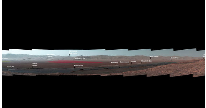
Check out this sweeping vista on the planet Mars, taken by the Curiosity rover from a mountainside ridge. It provides a look back at key sites visited by the rover since its 2012 landing.
View the image (much) larger: 
NASA’s Curiosity Mars rover took the panoramic image (below) from Vera Rubin Ridge on the north flank of the planet’s Mount Sharp. The view encompasses much of the 11-mile (18-km) route the rover has driven from its 2012 landing site, all inside Gale Crater. One hill on the northern horizon is about 50 miles (about 85 km) away, well outside the crater, though most of the scene’s horizon is the crater’s northern rim, roughly one-third that distance away and 1.2 miles (two km) above the rover.
Curiosity’s Mast Camera, or Mastcam, took the component images of the panorama on October 25, 2017, during the 1,856th Martian day, or sol, of the rover’s work on Mars. At that point, Curiosity had gained 1,073 feet (327 meters) in elevation and driven 10.95 miles (17.63 km) from its landing site. The mission has subsequently approached the southern edge of Vera Rubin Ridge and examined several outcrop locations along the way.
***
more: http://earthsky.org/space/panorama-view-of-mars-rovers-journey-so-far
 = new reply since forum marked as read

