Old Cold-War satellite images reveal ancient cities never discovered
Old cities through satellite images
26 APRIL, 2014 - 02:52 APRILHOLLOWAY
Old satellite images reveal lost cities and previously unknown ancient sites
Archaeologists have discovered numerous archaeological sites scattered across the Middle East thanks to work on the new Corona Atlas of the Middle East, which features Cold-War satellite images from Egypt to Iran, and encompassing the Fertile Crescent, one of the cradles of civilization and location of some of humanity’s earliest cities. According to a report in the National Geographic, the satellite photos have tripled the number of known archaeological sites across the region, revealing thousands of ancient cities, roads, canals, and other ruins.
There were already around 4,500 known archaeological sites across the Middle East, but the satellite images have revealed another 10,000 that were not previously known about. The largest sites, with some covering more than 123 acres, are believed to be Bronze Age cities which ancient walls and citadels.
"Some of these sites are gigantic, and they were completely unknown," says atlas-team archaeologist Jesse Casana of the University of Arkansas, who presented the results. "We can see all kinds of things—ancient roads and canals. The images provide a very comprehensive picture."
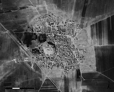
This 1961 satellite photo shows Tell Rifaat in northwest Syria; it's now completely surrounded by a modern town. Photo credit: Internet Archaeology / Jesse Casana, Jackson Cothren and Tuna Kalayci
http://www.ancient-origins.net/news-history-archaeology/old-satellite-images-reveal-lost-cities-and-previously-unknown-06789#.U1sRzc4SFM4.facebook
 = new reply since forum marked as read
